
Weather (Hessen)
| coat of arms | Germany map | |
|---|---|---|
.svg)
|
Coordinates: 50 ° 54 ' N , 8 ° 43' E |
|
| Basic data | ||
| State : | Hesse | |
| Administrative region : | to water | |
| County : | Marburg-Biedenkopf | |
| Height : | 208 m above sea level NHN | |
| Area : | 104.56 km 2 | |
| Residents: | 8803 (Dec. 31, 2019) | |
| Population density : | 84 inhabitants per km 2 | |
| Postal code : | 35083 | |
| Area code : | 06423 | |
| License plate : | MR, BID | |
| Community key : | 06 5 34 021 | |
| LOCODE : | DE TRS | |
| City structure: | Core city plus 9 districts |
|
City administration address : |
Marktplatz 1 35083 Wetter (Hesse) |
|
| Website : | ||
| Mayor : | Kai Uwe Spanka (independent) | |
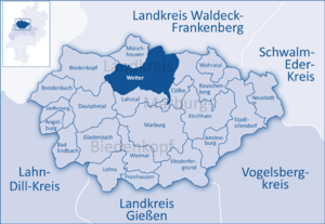
| Location of the city of Wetter (Hesse) in the Marburg-Biedenkopf district | ||
  |
||

Wetter (Hessen) is a small town in the district of Marburg-Biedenkopf in central Hesse . The rather uncommon name Wetter ( Hessen-Nassau ) comes from the time when it belonged to the Prussian province of the same name and was essentially only used by the railroad and the post office in the stamps.
geography
location
Wetter is located immediately south of the confluence of the Treisbach in the Wetschaft , about 14 km north of Marburg . All populated districts are in the Wetschaft depression , southwest of the city is the 474 m high Wollenberg . The eastern districts of the city (from south to north) Unterrosphe , Oberrosphe and Mellnau already border directly on the Burgwald , up to the slopes of which the higher elevations of Mellnau stretch. The western districts of Treisbach and Warzenbach , on the other hand, are already close to the wooded sackpipe forecrops that roof the Rothaargebirge , in which the Treisbach rises on the western slope of the 674 m high sackpipe , to the east. The Hollerberg ( 510 m ) is also the highest elevation of the local marker in the fore. While Warzenbach is framed in the southwest by the Wollenberg and the actual foothills to the east and west, Treisbach and Amönau am Treisbach, Oberndorf southwest of Amönau between this and the Wollenberg. At the Wetschaft, Todenhausen is to the north and Niederwetter is to the south of the city center.
Neighboring communities
Wetter borders the city of Rosenthal ( Waldeck-Frankenberg district ) in the northeast and the city of Rauschenberg in the east , both of which are, however, clearly separated by the castle forest. Southeast the municipality borders Cölbe , to the south the community Lahntalhotel and southwest the community Dautphetal , all at the Lahn and B 62 are, which on the B 252 is directly accessible along the Wetschaft. The town of Biedenkopf, which is adjacent to the west, is separated by the bagpipe forecourt, but can be reached more or less directly via Landesstraße 3091 along the Treisbach to the bagpipe or via Warzenbach and Dautphetal. In the north, along the Wetschaft-Senke and the B 252, the community of Münchhausen follows . All neighboring towns except Rosenthal are in the Marburg-Biedenkopf district.
Community structure
In addition to the core city, Wetter consists of the following outer districts (2016 population figures in brackets):
- Amonau (770)
- Mellnau (762)
- Low weather (284)
- Oberndorf (131)
- Oberrosphe (752)
- Todenhausen (243)
- Treisbach (566)
- Unterrosphe (550)
- Warzenbach (452)
history

Until the Hessian territorial reform
Weather is mentioned for the first time in the Codex Eberhardi (1150–1160). A Carolingian royal court in the middle of an extensive area of imperial property is assumed. He was likely to have been connected to the Frankish fort on the nearby Christenberg . The farm was located at a river crossing of the north-south running so-called Weinstrasse (Wagenstrasse) , an important supra-regional connection from the Frankfurt area to the Sachsenland ( Paderborn ). Settlement of the monastery mountain could be traced back to the 8th century through archaeological excavations. From the 11th century onwards, livestock farming can also be traced, as evidenced by hundreds of animal bones.
The market town of Wetter itself was referred to as “civitas” in 1223, making it one of the earliest cities in Hesse. As early as 1235, five citizens and Schöppen are mentioned, which is evidence of a city court. With the closure of the Wetter District Court in 1945, the tradition of jurisdiction in Wetter ended.
The Wetter monastery was probably created in the early 11th century; a connection to the Ottonian royal family is suspected. It was first mentioned in 1108. The monastery later served as an educational institution in addition to accepting female nobles. In 1266 a "Magister Konrad", and in 1323 a rector Heinrich, worked at the school of the monastery .
The development of the city, which later became the seat of an office, was slowed down by the activity of Elisabeth of Thuringia in Marburg and the later pilgrimage to the grave of the saints. After Marburg had become one of the most important places of pilgrimage in Germany and the Philipps University of Marburg was founded in the 16th century , Wetter slipped into insignificance. Several city fires (including 1622, 1626, 1629 and 1649), which only survived a few buildings, including the collegiate church, repeatedly set the city back in its development.
Incorporations
As part of the regional reform in Hesse , the state government approved the incorporation of the municipalities of Amönau, Mellnau, Niederwetter, Oberndorf, Oberrosphe, Todenhausen and Unterrosphe into the city of Wetter (Hessen-Nassau) in the former district of Marburg with effect from December 31, 1971 . The municipalities of Treisbach and Warzenbach followed by state law on July 1, 1974.
Territorial history and administration
The following list gives an overview of the territories in which the weather was located or the administrative units to which it was subject:
- before 1567: Holy Roman Empire , Landgraviate Hessen , Amt Wetter (The Amt Wetter consisted of the places Wetter, Amönau, Oberndorf, Treisbach, Niederasphe, Unterſimtshausen, Todenhausen, Melnau, Ober- and Niederrosphe, Niederwetter, Göttingen, Sterzhausen, Warzenbach and Sarnau )
- from 1567: Holy Roman Empire, Landgraviate Hessen-Marburg , Wetteramt
- 1604–1648: Holy Roman Empire, disputed between Landgraviate Hessen-Darmstadt and Landgraviate Hessen-Kassel ( Hessian War ), Weather Office
- from 1648: Holy Roman Empire, Landgraviate Hessen-Kassel, Wetter office
- from 1803: Holy Roman Empire, Electorate of Hesse , Wetter office
- from 1806: Electorate of Hesse, Marburg Office, Weather Office
- 1807–1813: Kingdom of Westphalia , Werra department , Marburg district , Wetter canton
- from 1815: German Confederation , Electorate of Hesse, Wetter office
- from 1821: German Confederation, Electorate of Hesse, Province of Upper Hesse , District of Marburg (separation of justice ( Justice Office Wetter ) and administration)
- from 1848: German Confederation, Electorate of Hesse, Marburg district
- from 1851: German Confederation, Electorate of Hesse, Province of Upper Hesse, District of Marburg
- from 1866: North German Confederation , Kingdom of Prussia , Province of Hesse-Nassau , District of Kassel , District of Marburg
- from 1871: German Empire , Kingdom of Prussia, Province of Hessen-Nassau, District of Kassel, District of Marburg
- from 1918: German Empire, Free State of Prussia , Province of Hessen-Nassau, Administrative Region of Kassel, District of Marburg
- from 1944: German Empire, Free State of Prussia, Province of Kurhessen , District of Marburg
- from 1945: American zone of occupation , Greater Hesse , Kassel district, Marburg district
- from 1949: Federal Republic of Germany , State of Hesse , Kassel district, Marburg district
- 1974: Federal Republic of Germany, Land Hessen, Kassel , Marburg-Biedenkopf
- from 1981: Federal Republic of Germany, State of Hesse, Gießen district, Marburg-Biedenkopf district
Courts since 1821
With an edict of June 29, 1821, administration and justice were separated in Kurhessen. Now judicial offices were responsible for the first instance jurisdiction, the administration was taken over by the districts. The Marburg district was responsible for the administration and the Wetter Judicial Office was the court of first instance for Wetter. The Supreme Court was the Higher Appeal Court in Kassel . The higher court of Marburg was subordinate to the province of Upper Hesse. It was the second instance for the judicial offices.
After the annexation of Kurhessen by Prussia, the judicial office of Wetter became the royal Prussian district court of Wetter in 1867 . In June 1867, a royal ordinance was issued that reorganized the court system in the areas that belonged to the former Electorate of Hesse. The previous judicial authorities were to be repealed and replaced by local courts in the first, district courts in the second and an appeal court in the third instance. In the course of this, on September 1, 1867, the previous judicial office was renamed the Wetter District Court. The courts of the higher authorities were the Marburg District Court and the Kassel Court of Appeal .
Even with the entry into force of the Courts Constitution Act (GVG) in 1877, the district court remained in existence. In 1943 the district court became a branch of the district court of Marburg and in 1946 the branch was also closed. The district of the district court of Wetter merged with the district of the district court of Marburg.
In the Federal Republic of Germany, the superordinate instances are the Marburg Regional Court , the Frankfurt am Main Higher Regional Court and the Federal Court of Justice as the last instance.
population
Population development
Source: Historical local dictionary
| • 1502: | 112 citizens, 41 servants, shepherds, day laborers |
| • 1577: | 200 house seats |
| • 1617: | 158 house seats |
| • 1681: | 107 home-seated teams |
| • 1747: | 149 households |
| • 1838: | 241 local residents entitled to use, 28 residents . |
| Weather: Population from 1781 to 2015 | ||||
|---|---|---|---|---|
| year | Residents | |||
| 1781 | 911 | |||
| 1834 | 1,325 | |||
| 1840 | 1,409 | |||
| 1846 | 1,395 | |||
| 1852 | 1,265 | |||
| 1858 | 1,184 | |||
| 1864 | 1,157 | |||
| 1871 | 1,129 | |||
| 1875 | 1,086 | |||
| 1885 | 1,167 | |||
| 1895 | 1,153 | |||
| 1905 | 1,199 | |||
| 1910 | 1,299 | |||
| 1925 | 1,497 | |||
| 1939 | 1,780 | |||
| 1946 | 2,482 | |||
| 1950 | 2,659 | |||
| 1956 | 2,575 | |||
| 1961 | 2,644 | |||
| 1967 | 2,816 | |||
| 1972 | 6,823 | |||
| 1976 | 8,524 | |||
| 1984 | 8,966 | |||
| 1992 | 9,057 | |||
| 2000 | 9,600 | |||
| 2010 | 9,148 | |||
| 2015 | 9,000 | |||
| Data source: Historical municipality register for Hesse: The population of the municipalities from 1834 to 1967. Wiesbaden: Hessisches Statistisches Landesamt, 1968. Further sources:; 1972 :; 1976 :; 1984 :; 1992 :; 2000, 2015 :; 2010: From 1972 including the towns incorporated into Hesse as part of the regional reform . | ||||
Religious affiliation
Source: Historical local dictionary
| • 1861: | 1005 Evangelical Lutheran , 147 Evangelical Reformed , 3 Roman Catholic, 24 Jewish residents. |
| • 1885: | 1089 Protestant (= 93.32%), 14 Catholic (= 1.20%), 61 Jewish (= 5.23%) and 3 (= 0.26%) residents of other denominations |
| • 1961: | 2265 Protestant (= 85.67%), 337 Roman Catholic (= 12.75%) residents |
Gainful employment
Source: Historical local dictionary
| • 1783: | 28 farmers, 14 bakers, 3 hackers, 1 turner, 1 dyer, 16 linen weavers, 4 bricklayers, 12 butchers, 3 quickmakers , 19 shoemakers, 4 saddlers, 1 stocking weaver, 6 carpenters, 2 blacksmiths, 3 locksmiths, 3 soap makers, 5 tailors , 2 trouser cutters, 3 millers, 1 papermaker with 2 journeymen, 1 wig maker, 1 wagner, 1 carpenter, 7 innkeepers, 18 spirits pourers, 5 day laborers, 4 shepherds, 13 individual women (sew and wash, and sometimes spin and pay for a day). |
| • 1838: | Families: 198 agriculture, 40 day laborers. |
| • 1961: | Labor force: 176 agriculture and forestry, 480 manufacturing, 233 trade and transport, 234 services and other. |
| • 1987: | Labor force: 1644 of which 42 (= 2.6%) agriculture and forestry, 617 (= 38.1%) manufacturing, 313 (= 19%) trade, traffic, news , 662 (40.3%) other areas. |
politics
City Council
The local elections on March 6, 2016 produced the following results, compared to previous local elections:
| Parties and constituencies |
% 2016 |
Seats 2016 |
% 2011 |
Seats 2011 |
% 2006 |
Seats 2006 |
% 2001 |
Seats 2001 |
||
|---|---|---|---|---|---|---|---|---|---|---|
| SPD | Social Democratic Party of Germany | 48.1 | 15th | 43.1 | 13 | 39.1 | 12 | 52.2 | 16 | |
| CDU | Christian Democratic Union of Germany | 29.1 | 9 | 29.9 | 9 | 40.5 | 12 | 33.2 | 10 | |
| GREEN | Alliance 90 / The Greens | 11.3 | 4th | 16.7 | 5 | 8.5 | 3 | 7.6 | 3 | |
| THE LEFT | The left | 8.1 | 2 | 5.7 | 2 | 2.6 | 1 | - | - | |
| FDP | Free Democratic Party | 3.4 | 1 | 4.6 | 2 | 9.4 | 3 | 7.1 | 2 | |
| total | 100.0 | 31 | 100.0 | 31 | 100.0 | 31 | 100.0 | 31 | ||
| Voter turnout in% | 49.7 | 51.4 | 49.4 | 55.9 | ||||||
mayor
In the direct election of the mayor on March 4, 2012, mayor Kai-Uwe Spanka , who has been in office since 2006, was re -elected with 70.76% (3,134 votes) for a further six years (from July 1, 2012).
Presentation right for the pastor
After Landgrave Philipp von Hessen took away the right to present the pastor of Wetter as a result of the Reformation , it was given to the magistrate. To this day, the magistrate has the right to propose an applicant to the regional bishop for a vacant pastor's position. The city is responsible for maintaining the church buildings.
coat of arms
Blazon : "In the golden (yellow) shield on a green three-mountain a green lily branch with three silver (white) flowers flanked by two inclined shields , in front the Hessian lion, behind the wheel of Mainz ."
The two shields commemorate the former joint rule of the Landgraves of Hesse and the Archbishops of Mainz over the city.
Partner communities
Culture and sights
City Archives
The archive of the city of Wetter, founded in 1993, preserves the tradition of the city administration and the magistrate, which began in the 16th century. In addition, the local newsletters of the city and parish are collected. The collection of official registers beginning in the 17th century is important. Some book bindings could be identified as high medieval monastery manuscripts of the dissolved Wetter monastery.
The documents of the Wetter Abbey are kept in the Marburg State Archives (inventory A II 30).
Buildings
.jpg)

- Former collegiate church of St. Maria , now Protestant parish church. The cruciform, originally towerless hall church with a turret was probably started in the middle of the 13th century. The west tower was added in 1506. With his pointed helmet he was once considered the highest church tower in Hesse. Shortened in 1783, it was removed from 1869 to 1871 and only replaced by the current pointed helmet in 1957/58. From 1859 to 1864 the building was extensively restored by Georg Gottlob Ungewitter . The strong interior colors were restored in 1962 based on findings. Similar color versions can be found in the Elisabethkirche (Marburg) and in the monastery church of Haina . The most important piece of equipment is a wooden altarpiece from the middle of the 13th century. It is one of the earliest retables. Further furnishings include a 13th century baptismal font with lions' heads, the Gothic celebrant's chair donated in 1466 and the magnificent organ by Johann Andreas Heinemann (1763–1766). The 23 glass windows were designed by the German artist Hans Gottfried von Stockhausen .
- Town hall - timber-framed building with a dwarf house , slated on the upper floors , built around 1680. The ground floor is massive. Recently expanded with new buildings.

- Residential buildings - The townscape, which is still largely closed, is primarily characterized by half-timbered houses with gable ends, most of which, however, are slated or plastered. After two city fires (1629 and 1649), however, only a few buildings that were built before 1629 are left. The oldest and most important houses in the village can be found on the west side of the market square. Markt 7 , which was built in 1570 by Hermann Pincier , the Hessian bailiff zu Nidda, is particularly stately : two upper floors made of half-timbered construction rise above two massive basement floors. The house has a polygonal corner bay window and a renaissance portal, which is marked "1570". The former Gasthaus zum Engel at Markt 11 is likely to come from this time . The plastered and repeatedly modified half-timbered building was built in 1575 according to the inscription. Markt 9 , which dates back to the first third of the 16th century, was built a little earlier than these two houses . The second floor is said to have been added around 1700. Also noteworthy are Markt 8 (17th century) and the earlier office building , Obertor 2. Like Markt 7, it has a corner bay window that is completely slated. The nearby Krämergasse has other half-timbered buildings that are well worth seeing . While the wall stud construction with house number 10 probably dates back to the first third of the 16th century, house no. 14, with carved panels, was built after the great city fire of 1649: "MITT GOTTES HÜLF DIS HOUSE BUILT * JOHAN PHILIPS VOLMAR HOW YOU LOOK * AND ANNA GERDRUT DESSEN WISS. * THE HIGHEST KEEP YOU FROM TIME * FROM WAR AND BRA.D AND EVERYTHING LEIDD * ANNO 1671 "In addition, several houses still have classicist doors.
.jpg)
- Remains of the medieval city wall with two towers have been preserved, especially in the south and west. There is a round tower built around 1200 on Leitergasse. To the east of the church is the so-called Diebsturm (mostly 15th century), the roof of which was recently renewed.
Regular events
The Grenzegangfest takes place every seven years , the last from August 5th to 11th, 2015.
Economy and Infrastructure
traffic
The federal highway 252 runs through the urban area in a north-south direction from East Westphalia-Lippe via Korbach and Frankenberg (Eder) to Göttingen (municipality of Lahntal ). In order to remove the heavy traffic from the places in the Wetschaft Valley, a bypass road is currently being built. The section to bypass Wetter is to be completed at the end of 2019. However, the project is highly controversial, as the construction of the so-called western bypass would affect important nature reserves and recreational areas for the city. The relief of the Wetschaft Valley would also be bought with a significant additional burden on Wetter-West, which is also important in the cost-benefit analysis of the construction project.
The Burgwaldbahn connects the city with Marburg and Korbach and Bestwig . The section between Frankenberg and Bestwig was reopened in 2015.
Personalities
sons and daughters of the town
- Johann Dryander (1500–1560), anatomist , doctor, astronomer and physician
- Volkwin Weigel (~ 1516–1579), mathematics professor and personal physician
- Justus Vultejus (1529–1575), educator and philologist
- Friedrich Sylburg (1536–1596), Graecist and editor
- Wigand Orth (1537–1566), Protestant theologian
- Oswald Croll (1560–1609), physician and pharmacopoeia author
- Eberhard Mesomylius (~ 1570–1630), Lutheran theology professor
- Heinrich Eckhard (1580–1624), Lutheran clergyman
- Johannes Combach (1585–1651), philosopher and theologian
- Hermann Vultejus (1555–1634), German lawyer and rector of the University of Marburg
- Peter Dickel (1819–1896), organ builder born in Treisbach
- Karl Heinrich Schäfer (1871–1945), archivist and historian
- Rudolf Braun (1889–1975), entrepreneur, member of the Reichstag ( NSDAP ) and NSDAP regional economic advisor
- Heinrich Buchenauer (* 1940), agricultural scientist
- Fred Steinfort (born 1952), American football player
Personalities who have worked in Wetter
- Johannes Rauw (? –1600), cosmographer, theologian and composer, died in Wetter (Hesse)
- Johannes Fokken (* 1939), teacher and former head of the Wollenberg School in Wetter, long-time city councilor and district councilor ( SPD ), holder of the Federal Cross of Merit on Ribbon, resident in Wetter
- Claudia Kuhnhen (* approx. 1944), doctor and former head of the health department of the Marburg-Biedenkopf district , holder of the Federal Cross of Merit on Ribbon (awarded on November 21, 2005)
- Christian Engelhardt (* 1972), legal scholar and politician (CDU), former city councilor of the city of Wetter (Hesse), lived in Wetter (Hesse)
literature
- Hans Gottfried von Stockhausen: The collegiate church to weather and its glass paintings. Hirmer, Munich 2007, ISBN 978-3-7774-3875-7 .
- August Heldmann: "On the older history of the monastery, the church and city of Wetter, and Mellnau Castle". In: Journal of the Association for Hessian History and Regional Studies, New Series, Volume 24, First Half, Kassel, 1899 (pp. 69–142)
- Literature about weather in the Hessian Bibliography
Web links
- Website of the city of Wetter
- History of weather. In: www.wetter-in-hessen.de. Private website
- Wetter, municipality, district of Marburg-Biedenkopf. Historical local dictionary for Hessen. In: Landesgeschichtliches Informationssystem Hessen (LAGIS).
- Wetter (Hessen), Marburg-Biedenkopf district. Historical local dictionary for Hessen. In: Landesgeschichtliches Informationssystem Hessen (LAGIS).
- Information on the municipality of Wetter (Hessen). In: Hessisches Gemeindelexikon. HA Hessen Agentur GmbH , 2016.
- Maps of weather . Hessian city atlas. In: Landesgeschichtliches Informationssystem Hessen (LAGIS).
- Text booklet weather . Hessian city atlas. In: Landesgeschichtliches Informationssystem Hessen (LAGIS). (PDF; 342 kB)
Individual evidence
- ↑ Hessian State Statistical Office: Population status on December 31, 2019 (districts and urban districts as well as municipalities, population figures based on the 2011 census) ( help ).
- ↑ Budget 2016 (statistical information - main residences) of the city of Wetter (PDF 5.4 MB), accessed on March 29, 2018
- ^ Municipal reform in Hesse: amalgamation and integration of municipalities from December 14, 1971 . In: The Hessian Minister of the Interior (ed.): State Gazette for the State of Hesse. 1972 No. 2 , p. 47 ff ., point 50, paragraph 1 ( online at the information system of the Hessian state parliament [PDF; 6.0 MB ]).
- ↑ Law on the reorganization of the Biedenkopf and Marburg districts and the city of Marburg (Lahn) (GVBl. II 330-27) of March 12, 1974 . In: The Hessian Minister of the Interior (ed.): Law and Ordinance Gazette for the State of Hesse . 1974 No. 9 , p. 154 , § 3 ( online at the information system of the Hessian state parliament [PDF; 3.0 MB ]).
- ^ Federal Statistical Office (ed.): Historical municipality directory for the Federal Republic of Germany. Name, border and key number changes in municipalities, counties and administrative districts from May 27, 1970 to December 31, 1982 . W. Kohlhammer, Stuttgart / Mainz 1983, ISBN 3-17-003263-1 , p. 404 .
- ↑ a b c d e Wetter (Hessen), Marburg-Biedenkopf district. Historical local dictionary for Hessen. (As of March 28, 2018). In: Landesgeschichtliches Informationssystem Hessen (LAGIS).
- ^ Michael Rademacher: German administrative history from the unification of the empire in 1871 to the reunification in 1990. State of Hesse. (Online material for the dissertation, Osnabrück 2006).
- ^ Georg Landau: Description of the Electorate of Hesse . T. Fischer, Kassel 1842, p. 389 ( online at HathiTrust's digital library ).
- ^ Kur-Hessischer Staats- und Adress-Kalender: 1818 . Publishing house d. Orphanage, Kassel 1818, p. 123 ( online at Google Books ).
- ↑ Ordinance of August 30th, 1821, concerning the new division of the area , Annex: Overview of the new division of the Electorate of Hesse according to provinces, districts and judicial districts. Collection of laws etc. for the Electoral Hesse states. Year 1821 - No. XV. - August., ( Kurhess GS 1821) pp. 223-224
- ↑ Latest news from Meklenburg / Kur-Hessen, Hessen-Darmstadt and the free cities, edited from the best sources. in the publishing house of the GHG privil. Landes-Industrie-Comptouts., Weimar 1823, p. 158 ff . ( online at HathiTrust's digital library ).
- ↑ Ordinance on the constitution of the courts in the former Electorate of Hesse and the formerly Royal Bavarian territories with the exclusion of the enclave Kaulsdorf from June 19, 1867. ( PrGS 1867, pp. 1085-1094 )
- ↑ Order of August 7, 1867, regarding the establishment of the according to the Most High Ordinance of June 19 of this year. J. in the former Electorate of Hesse and the formerly Royal Bavarian territorial parts with the exclusion of the enclave Kaulsdorf, courts to be formed ( Pr. JMBl. Pp. 221–224 )
- ^ Local elections 1972; Relevant population of the municipalities on August 4, 1972 . In: The Hessian Minister of the Interior (ed.): State Gazette for the State of Hesse. 1972 No. 33 , p. 1424 , point 1025 ( online at the information system of the Hessian state parliament [PDF; 5.9 MB ]).
- ↑ Local elections 1977; Relevant population figures for the municipalities as of December 15, 1976 . In: The Hessian Minister of the Interior (ed.): State Gazette for the State of Hesse. 1976 No. 52 , p. 2283 , point 1668 ( online at the information system of the Hessian state parliament [PDF; 10.3 MB ]).
- ^ Local elections 1985; Relevant population of the municipalities as of October 30, 1984 . In: The Hessian Minister of the Interior (ed.): State Gazette for the State of Hesse. 1984 No. 46 , p. 2175 , point 1104 ( online at the information system of the Hessian state parliament [PDF; 5.5 MB ]).
- ↑ local elections 1993; Relevant population of the municipalities as of October 21, 1992 . In: The Hessian Minister of the Interior (ed.): State Gazette for the State of Hesse. 1992 No. 44 , p. 2766 , point 935 ( online at the information system of the Hessian state parliament [PDF; 6.1 MB ]).
- ^ Municipal data sheet : Weather. (PDF; 222 kB) In: Hessisches Gemeindelexikon. HA Hessen Agency GmbH
- ↑ The population of the Hessian municipalities on June 30, 2010. (PDF; 552 kB) (No longer available online.) Hessisches Statistisches Landesamt, p. 11 , archived from the original on February 7, 2018 ; accessed on March 20, 2018 .
- ↑ Ursula Braasch-Schwersmann (Ed.): Weather, text booklet . Marburg 2005, ISBN 3-87707-642-4 , pp. 16 ( Online at Landesgeschichtliches Informationssystem Hessen [PDF; 334 kB ]).
- ^ Result of the municipal election on March 6, 2016. Hessian State Statistical Office, accessed in April 2016 .
- ^ Hessian State Statistical Office: Result of the municipal elections on March 27, 2011
- ^ Hessian State Statistical Office: Result of the municipal elections on March 26, 2006
- ↑ Mayoral election in Wetter (Hessen), city. Hessian State Statistical Office , accessed in May 2019 .
- ↑ Grenzegang Wetter on the city's website

Amöneburg | Fishing castle | Bad Endbach | Biedenkopf | Breidenbach | Cölbe | Dautphetal | Ebsdorfergrund | Fronhausen | Gladenbach | Kirchhain | Lahn valley | Lohra | Marburg | Munchausen | Neustadt (Hessen) | Rauschenberg | Stadtallendorf | Steffenberg | Weimar (Lahn) | Weather (Hessen) | Wohratal
Amönau | Mellnau | Low weather | Oberndorf | Oberrosphe | Todenhausen | Treisbach | Unterrosphe | Warzenbach | Weather