Killem
| Killem | ||
|---|---|---|

|
|
|
| region | Hauts-de-France | |
| Department | North | |
| Arrondissement | Dunkerque | |
| Canton | Wormhout | |
| Community association | Hauts de Flandre | |
| Coordinates | 50 ° 58 ′ N , 2 ° 34 ′ E | |
| height | 1–19 m | |
| surface | 11.99 km 2 | |
| Residents | 1,116 (January 1, 2017) | |
| Population density | 93 inhabitants / km 2 | |
| Post Code | 59122 | |
| INSEE code | 59326 | |
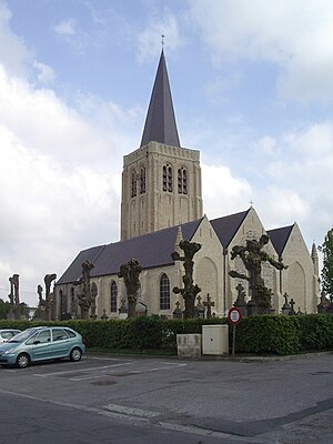
 Saint-Michel church |
||
Killem is a French commune with 1,116 inhabitants (at January 1, 2017) in Nord in the region of Hauts-de-France . It belongs to the Arrondissement of Dunkerque and the Canton of Wormhout .
geography
The municipality is located around 20 kilometers southeast of Dunkirk , near the Belgian border, in the French Flanders countryside . Neighboring communities of Killem are Hondschoote in the north and east, Oost-Cappel in the southeast, Rexpoëde in the south and Warhem in the west. The Becque de Killem brook runs along the north-western boundary of the municipality and the similar-sounding Killem Becque runs along the north-eastern boundary . This flows into the Beque de Killem at the municipal boundary, which finally reaches the Canal de la Basse Colme between Warhem and Hondschoote .
Population development
| year | 1968 | 1975 | 1982 | 1990 | 1999 | 2006 | 2010 | 2016 |
| Residents | 823 | 820 | 849 | 976 | 991 | 968 | 964 | 1,084 |
Attractions
- Saint-Michel church from the 17th century, with valuable furnishings
literature
- Le Patrimoine des Communes du Nord. Flohic Editions, Volume 1, Paris 2001, ISBN 2-84234-119-8 , pp. 870-871.
Web links
- Monuments historiques (objects) in Killem in the base Palissy of the French Ministry of Culture
