
Saint-Sylvestre-Cappel
| Saint-Sylvestre-Cappel | ||
|---|---|---|
.svg)
|
|
|
| region | Hauts-de-France | |
| Department | North | |
| Arrondissement | Dunkerque | |
| Canton | Bailleul | |
| Community association | Flandre Intérieure | |
| Coordinates | 50 ° 47 ' N , 2 ° 33' E | |
| height | 28-58 m | |
| surface | 8.14 km 2 | |
| Residents | 1,180 (January 1, 2017) | |
| Population density | 145 inhabitants / km 2 | |
| Post Code | 59114 | |
| INSEE code | 59546 | |
| Website | http://www.saint-sylvestre-cappel.fr/ | |

Saint-Sylvestre-Cappel , West Flemish : Sint-Silvester-Kapel , is a municipality in French Flanders in France . It belongs to the Hauts-de-France region , the Nord department , the Dunkerque arrondissement and the Bailleul canton (until 2015: Steenvoorde canton ). It borders Terdeghem to the north, Eecke to the east, Hondeghem to the south and Sainte-Marie-Cappel to the west . The residents call themselves Cappelois .
The former Route nationale 16 leads via Saint-Sylvestre-Cappel.
Population development
| year | 1962 | 1968 | 1975 | 1982 | 1990 | 1999 | 2008 | 2013 |
|---|---|---|---|---|---|---|---|---|
| Residents | 716 | 724 | 870 | 1,045 | 1,019 | 1,073 | 1,091 | 1.009 |
Attractions
- Saint-André church
- War memorial
economy
The Brasserie de Saint Sylvestre is a brewery that still exists today .
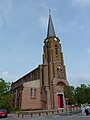
Saint-André church, south facade
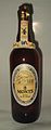
“3 Monts Beer”, a product from Brasserie de Saint Sylvestre

The Mairie
_%C3%A9glise,_fa%C3%A7ade_sud.JPG)
_mairie.JPG)
literature
- Le Patrimoine des Communes du Nord. Flohic Editions, Volume 2, Paris 2001, ISBN 2-84234-119-8 , pp. 1551-1552.
Web links
Commons : Saint-Sylvestre-Cappel - Collection of images, videos and audio files
- Monuments historiques (objects) in Saint-Sylvestre-Cappel in the base Palissy of the French Ministry of Culture