
Caëstre
|
Caëstre Kaester |
||
|---|---|---|
_Nord-France.svg)
|
|
|
| region | Hauts-de-France | |
| Department | North | |
| Arrondissement | Dunkerque | |
| Canton | Bailleul | |
| Community association | Flandre Intérieure | |
| Coordinates | 50 ° 46 ′ N , 2 ° 36 ′ E | |
| height | 24-62 m | |
| surface | 10.2 km 2 | |
| Residents | 1,980 (January 1, 2017) | |
| Population density | 194 inhabitants / km 2 | |
| Post Code | 59190 | |
| INSEE code | 59120 | |
| Website | http://www.caestre.fr/ | |
 Town hall (Mairie) of Caëstre |
||

Caëstre ( Flemish : Kaaster - in West Flanders also Käster ) is a French town in Nord in the region of Hauts-de-France in the historic West Flemish -speaking region French Flanders . Caëstre has 1,980 inhabitants (as of January 1, 2017), called Caestrois , and belongs to the canton of Bailleul (until 2015: canton of Hazebrouck-Nord ) in the arrondissement of Dunkerque .
location
Caëstre is about 57 kilometers southeast of Calais and about 34 kilometers south-southeast of Dunkirk . Caëstre is surrounded by the neighboring communities of Eecke in the north, Flêtre in the east, Pradelles and Borre in the south, Hazebrouck in the southwest, Hondeghem in the west and Saint-Sylvestre-Cappel in the west.
Population development
| 1962 | 1968 | 1975 | 1982 | 1990 | 1999 | 2006 | 2012 |
|---|---|---|---|---|---|---|---|
| 1,114 | 1,164 | 1,191 | 1,340 | 1,597 | 1,677 | 1,670 | 1,906 |
| Source: Cassini and INSEE | |||||||
Attractions
- Saint-Omer church
- Les Trois Vierges chapel
- British military cemetery
- Saint Joseph Mill
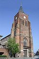
Saint-Omer church

Les Trois Vierges chapel


literature
- Le Patrimoine des Communes du Nord. Flohic Editions, Volume 1, Paris 2001, ISBN 2-84234-119-8 , pp. 819-821.
Web links
Commons : Caëstre - collection of images, videos and audio files
- Monuments historiques (objects) in Caëstre in the base Palissy of the French Ministry of Culture