
Steenbecque
| Steenbecque | ||
|---|---|---|
.svg)
|
|
|
| region | Hauts-de-France | |
| Department | North | |
| Arrondissement | Dunkerque | |
| Canton | Hazebrouck | |
| Community association | Flandre Intérieure | |
| Coordinates | 50 ° 41 ′ N , 2 ° 29 ′ E | |
| height | 17-65 m | |
| surface | 11.96 km 2 | |
| Residents | 1,690 (January 1, 2017) | |
| Population density | 141 inhabitants / km 2 | |
| Post Code | 59189 | |
| INSEE code | 59578 | |
| Website | http://www.steenbecque.fr/ | |
_mairie.JPG) Steenbecque Town Hall |
||

Steenbecque ( Dutch Steenbeke or Steenbeeke ) is a French municipality with 1,690 inhabitants (as of January 1 2017) in Nord in the region of Hauts-de-France . It belongs to the arrondissement of Dunkerque and the canton of Hazebrouck (until 2015: canton of Hazebrouck-Sud ).
geography
Steenbecque is about 35 kilometers west of Lille . Neighboring communities of Steenbecque are Morbecque in the north and east, Thiennes in the south and south-west, Boëseghem in the west and south-west and Blaringhem in the west and north-west.
Population development
| year | 1962 | 1968 | 1975 | 1982 | 1990 | 1999 | 2006 | 2012 |
| Residents | 1,447 | 1,497 | 1,469 | 1,485 | 1,553 | 1,612 | 1,692 | 1,742 |
| Source: Cassini and INSEE | ||||||||
Attractions
- Saint-Pierre church
- Calvaire at the church
- Old hospice
- Old school, built in the Flemish style

Saint-Pierre church
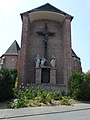
Calvaire

Old hospice

Old school
_%C3%A9glise_01.JPG)
_%C3%A9glise,_calvaire_au_chevet.JPG)
_ancien_hospice.JPG)
_la_maison_flamande,_(ancienne)_%C3%A9cole.JPG)
literature
- Le Patrimoine des Communes du Nord. Flohic Editions, Volume 1, Paris 2001, ISBN 2-84234-119-8 , pp. 849-851.
Web links
Commons : Steenbecque - collection of images, videos and audio files
- Monuments historiques (objects) in Steenbecque in the base Palissy of the French Ministry of Culture