Uxem
| Uxem | ||
|---|---|---|

|
|
|
| region | Hauts-de-France | |
| Department | North | |
| Arrondissement | Dunkerque | |
| Canton | Coudekerque branch | |
| Community association | Hauts de Flandre | |
| Coordinates | 51 ° 1 ′ N , 2 ° 29 ′ E | |
| height | -2-3 m | |
| surface | 8.27 km 2 | |
| Residents | 1,411 (January 1, 2017) | |
| Population density | 171 inhabitants / km 2 | |
| Post Code | 59229 | |
| INSEE code | 59605 | |
| Website | http://www.uxem.fr/ | |
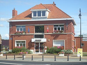
 Mairie Uxem |
||
Uxem , Dutch Uksem , is a French municipality with 1411 inhabitants (at January 1, 2017) in the department of Nord in the region of Hauts-de-France . It belongs to the Arrondissement of Dunkerque and to the Hauts de Flandre community association founded in 2014 . West Flemish is still spoken in Uxem .
geography
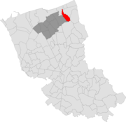
The municipality of Uxem is located in French Flanders in the far north of France, about eight kilometers east of Dunkirk and eight kilometers west of the border with Belgium (municipality of Veurne ). The table-level area of the municipality is crossed by small rivers such as the Moldyck . Furthermore, numerous canals run on different levels in the 9.28 km² large municipal area, which is largely below sea level, the task of which is to collect the surface water, which is pumped into a higher-lying canal by means of electric pumps. The water ultimately ends up in the Canal de Dunkerque à Furnes , which is connected to the sea. Water also reaches the North Sea via Belgian territory via the Ringsloot Canal .
In addition to the closed settlement image of the core town, there are numerous scattered individual farms in the municipal area of Uxem. The area is characterized by pasture farming on partially diked polders and the complete absence of forest areas.
Neighboring municipalities of Uxem are Ghyvelde in the northeast, Les Moëres in the east, Warhem in the south, Téteghem in the west and Leffrinckoucke in the northwest.
The A16 autoroute runs through the north of the municipality . A road bridge over this highway marks the highest point in the municipality at 10 m above sea level. The highest elevations are some 3 m high bumps in the north of Uxem.
history
Origins
The oldest traces of the village date from the 4th century. During this time, the peak of the then regular incursions of the sea into the hinterland ("deuxième transgression dunkerquienne" - Second Dunkirk flood ) falls . A labyrinth of lakes, swamps and islands of fertile soil was created. From the beginning of the 4th century, the power of the Romans gradually waned. The Romans were uncomfortable with wetlands and so they left the area. Saxon and Frisian clans immigrated to the land that belonged to Neustria from the 7th century under the rule of the Frankish king Dagobert . The village was named after one of the clan leaders named Ukes, Hugues, Hugo, Udon, Odon . The ending -hem or -ham stands for -haus or -heim . A first written source of the place comes from the year 981, when the village was called Ukesham . According to linguists and toponymists, the Saxon-Frisian ending -ham shifted to the Franconian -hem . In addition to Uxem, this also applies to the nearby villages of Téteghem and Warhem . L. Lemaire writes in his treatise on the history of Dunkirk ( L'histoire de Dunkerque ) in 1927 that those fleeing from the sea occupied the settlements on the new coastlines further inland - today's villages with the name endings ending in -hem, -ham or -zeele . The waves of immigration in the 9th and 10th centuries, on the other hand, brought place names with church references ( -kerque, -capelle or Saint- ).
The place name developed as follows: 981 Ukesham, 1067 Oxhem, 1075 Uggeshem, 1093 Usem, 1121 Oxham, 1254 Uxem, 1330 Uxhem, 1531 Uxcem and since 1559 Uxem.
middle Ages
A knight named Eustache d'Uxem is confirmed for the year 1232 , who granted the monks of the Abbey of St. Winnoc in nearby Bergues free passage over his rule of Uxem. This document has long been interpreted to mean that the monks of the Abbey of St. Winnoc could have founded the village of Uxem, but this does not match the place name and the coat of arms. The monks acquired numerous lands around Uxem until the French Revolution. The secular power over Uxem until the revolution lay with the castellanry of Bergues. In 1328 the Battle of Cassel also affected the village of Uxem, which left 21 dead.
Second World War
Although the First , Second and Third Battles of Flanders raged only about 40 kilometers east of Uxem, the Second World War was more devastating for the community and its residents. The front rolled over the Uxem area twice. In May and June 1940 the Germans advanced here on the nearby Dunkirk . The village was badly destroyed by bombs and large areas around Uxem were impassable due to land mines. Heavy fighting took place around the positions of gun batteries around the hamlets of Caesterhof, Krommenhouck and Le Petite Casino . Part of the defense strategy was to open canal locks (May 22, 1940) and turn off pumping stations so that large areas of the area below sea level were flooded. The German occupation incorporated the area around Uxem into the Atlantic Wall , which consisted of 24 bunkers.
After the war
Uxem and many surrounding villages were almost completely razed to the ground, 120,000 landmines had to be defused or blown up in the area and almost 25,000 hectares of land was covered with brackish water meters high. Locks, pumping stations and canals were destroyed.
The municipality was awarded the Croix de guerre in 1949 .
In January 1946, the flooded areas were provisionally drained. The soil of the polders was enriched with calcium sulphate and from 1947 the earth could be returned to agricultural use. The repair of the canals, locks and pumps, however, continued until the 1960s.
Population development
| year | 1962 | 1968 | 1975 | 1982 | 1990 | 1999 | 2006 | 2017 | |
|---|---|---|---|---|---|---|---|---|---|
| Residents | 342 | 339 | 682 | 950 | 1128 | 1076 | 1171 | 1411 | |
| Sources: Cassini and INSEE | |||||||||
Attractions
- Water tower
- Oratorio
- Log cabin
- The current church of Saint-Amand (St. Amandus ) is the second successor to the original church from the 17th century. This was destroyed by bombs in 1940. Only one painting (“The Adoration of the Magi”), two wooden statues of St. Amand and St. Apollonia, a monstrance, scrolls and records of the community remained intact. The aforementioned remains are kept in the Archdiocese of Lille . The ruins of the church, which had been destroyed in the war, were removed in 1962. In 1969 a new church was consecrated in the same place, which attracted attention with its modern stained glass. A lot of wood was built into this church, which soon turned out to be unfavorable. On January 8, 1986, the church burned down completely in an hour. The cause of the fire could not be clarified. Immediately afterwards, however, a new church began to be built. This current Saint-Amant church has existed since 1988.
Economy and Infrastructure
Agriculture still plays an important role in Uxem. Twelve farms are located in the community (grain cultivation, cattle breeding), as well as some small craft and service companies. In the north of the municipality, Uxem has a share in the Usine des Dunes industrial park together with the municipalities of Leffrinckoucke and Ghyvelde . The industrial area was founded in 1911. The largest employer there is Ascométal , today a subsidiary of the Russian Severstal group with almost 1000 employees (2008).
Uxem is somewhat remote from the national traffic flows, but is connected to the surrounding cities and communities by a well-developed road network in all directions. In Dunkerque , eight kilometers away, there are rail connections to the French heartland and Belgium. The A 16 autoroute (connections in Dunkerque and Ghyvelde ) runs through the north of the municipality of Uxem .
literature
- Le Patrimoine des Communes du Nord. Flohic Editions, Volume 1, Paris 2001, ISBN 2-84234-119-8 , pp. 757-758.
supporting documents
- ↑ Les origines du village on www.ville-uxem.com (French)
- ↑ X ème - XIII ème siècle on www.ville-uxem.com (French)
- ↑ La bataille de Cassel, author: Michel Warlop (French)
- ↑ La guerre 1939–1945 on www.ville-uxem.com (French)
- ↑ Bilan de la guerre on www.ville-uxem.com (French)
- ↑ Uxem on cassini.ehess.fr
- ↑ Uxem on insee.fr
- ↑ Paroisse d'Uxem (French)
- ↑ Farmers in Uxem (French)


