
Bergues
| Bergues | ||
|---|---|---|
_Nord-France.svg)
|
|
|
| region | Hauts-de-France | |
| Department | North | |
| Arrondissement | Dunkerque | |
| Canton | Coudekerque branch | |
| Community association | Hauts de Flandre | |
| Coordinates | 50 ° 58 ′ N , 2 ° 26 ′ E | |
| height | 1–22 m | |
| surface | 1.32 km 2 | |
| Residents | 3,653 (January 1, 2017) | |
| Population density | 2,767 inhabitants / km 2 | |
| Post Code | 59380 | |
| INSEE code | 59067 | |
| Website | http://www.bergues.fr/ | |
 town hall |
||


Bergues ( Dutch Sint-Winoksbergen or Bergen ) is a French commune in the Nord in the region of Hauts-de-France . It belongs to the Arrondissement of Dunkerque and until its dissolution in 2015 was the main town (chef-lieu) of the canton of the same name , since then it has belonged to the canton of Coudekerque-Branche .
geography
The small town with 3653 inhabitants (at January 1, 2017) is located on the northwest edge of the eponymous hill Grönberg (of NDL. : Groen Mountain / dt. "Green Mountain") in the historical province of Flanders in the landscape Blootland extending along the northern French and Belgian Channel coast , and is located about ten kilometers south of Dunkerque and 15 kilometers from the border with Belgium . Blootland is Flemish and means empty, bare land , which characterizes the coastal marshland, which is poor in wood . Neighboring communities are Téteghem-Coudekerque-Village in the northwest , Hoymille in the east, Quaëdypre in the southeast , Socx in the south and Bierne in the west .
Bergues is surrounded by several canals . The Canal de la Basse Colme runs through the northern edge of the city center from west to east . The Canal de Bergues has linked the city with Dunkirk since 1634 .
history
When the Normans began their invasions in the Bergues area in the second half of the 9th century, Count Baldwin II of Flanders had the place surrounded by a not very strong city wall. He founded a church here around 900, to which he had the remains of St. Winoc transferred. As a result, this church developed into a place of pilgrimage, namely to the Abbey of St. Winoc. In the 11th century, the city was destroyed by a flood, but was soon rebuilt. In the 12th and 13th centuries it was a regional center of the wool industry and the capital of an important burgraviate. This was granted privileges through a charter in 1240, which were later confirmed several times. In the 13th century Bergues was also a member of the London Hanseatic League.
In 1297 Count Robert II of Artois took possession of Bergues for the French King Philip IV , but in 1301 the French were expelled and the city came to the Count of Flanders. The English occupied it in the second half of the 14th century. After the Battle of Roosebeke , Charles VI's troops conquered . on September 3, 1383 the city, they looted and incinerated. Duke Philip the Bold had Bergues rebuilt, but a fire destroyed it again in 1494.

,_sent_Feb_1915_(6255470084).jpg)
The French Marshal De Thermes stormed Bergues in 1558; he had the inhabitants cut down and the city burned down. Through the Peace of Cateau-Cambrésis (1559) the city fell to King Philip II of Spain, who had it rebuilt. In the course of the Eighty Years War Bergues was besieged in 1583 by Alessandro Farnese , who conquered it and destroyed it again. Once again Philip II allowed its restoration, from which the present-day cityscape essentially derives.
In 1658, Louis XIV's troops took Bergues, which fell back to Spain the next year as a result of the Peace in the Pyrenees . In the war of devolution (1667), Louis XIV personally besieged the city. It was conquered and finally came to France through the Peace of Aachen in 1668. Immediately afterwards, Vauban received the order to fortify it. The Sun King, however, had Dunkerque (German Dunkirk) expanded into a large port, which made Bergues less important.
After the outbreak of the French Revolution , Bergues became the capital of a district in 1790 that later became the Arrondissement of Dunkerque . The Duke of York besieged Bergues in 1793 at the same time as Dunkerque, but had to withdraw unsuccessfully after the Battle of Hondschoote . The decline of the city, however, continued. It was badly affected by bombardments in World War I and in 1940 in World War II during the Battle of Dunkirk .
Population development
| year | 1793 | 1851 | 1891 | 1911 | 1931 | 1946 | 1962 | 1975 | 1990 | 1999 | 2007 | 2011 |
|---|---|---|---|---|---|---|---|---|---|---|---|---|
| Residents | 6,108 | 5,968 | 5,380 | 4,856 | 3,756 | 3,237 | 4,469 | 4,485 | 4.163 | 4,209 | 3,923 | 3,898 |
Attractions
See also: List of Monuments historiques in Bergues
- The city wall, which is partly from the Middle Ages and partly expanded by Vauban , is 5.3 kilometers long.
- The belfry , begun in the 14th and completed in the 16th century, destroyed by German troops in 1944 and rebuilt in 1961, has been a UNESCO World Heritage Site in France since 2005 .
- From the monastery Saint-Winoc , which was largely destroyed in 1789, which is Tour Carrée been preserved from the 11th and 12th centuries. Next to this tower is the Tour Pointue , which was rebuilt in 1812.
- Five city gates are listed as monuments historiques .
- In 1558 the old Saint-Martin church was sacked, but was rebuilt with a north tower at the end of the 16th century. It was badly damaged in 1944, but completely renovated after the war.
- The Canal de Bergues leads to Dunkirk. It was built in the 16th century as a connection to the sea. It is one of the oldest canals in France.

Tour Carrée

Tour pointue

City gate Porte de Bierne

Porte de Cassel city gate

Porte de Dunkerque
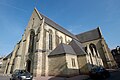
Saint Martin Church
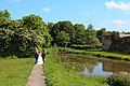
Moat and city wall

Basse-Colme Canal
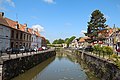
Rue du Port and Quai de la Manutention
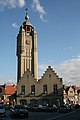
Belfry
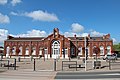
railway station


.JPG)

.jpg)

_2.jpg)


.JPG)
_2_.JPG)
Movie
The location is the main setting for the comedy film Welcome to the Sch'tis by director Dany Boon .
Community partnerships
- Erndtebrück , North Rhine-Westphalia, since 1973
literature
- Le Patrimoine des Communes du Nord. Flohic Editions, Volume 1, Paris 2001, ISBN 2-84234-119-8 , pp. 246-267.
Web links
Individual evidence
- ↑ Les canaux de Bergues at ot-hautsdeflandre.fr, accessed on July 24, 2019