
Fletre
| Fletre | ||
|---|---|---|
_Nord-France.svg)
|
|
|
| region | Hauts-de-France | |
| Department | North | |
| Arrondissement | Dunkerque | |
| Canton | Bailleul | |
| Community association | Flandre Intérieure | |
| Coordinates | 50 ° 45 ′ N , 2 ° 39 ′ E | |
| height | 26-88 m | |
| surface | 8.98 km 2 | |
| Residents | 972 (January 1, 2017) | |
| Population density | 108 inhabitants / km 2 | |
| Post Code | 59270 | |
| INSEE code | 59237 | |
_mairie.JPG) Mairie Fletre |
||

Flêtre ( West Flemish : Vletern or Vleeter ) is a municipality in French Flanders . It belongs there to the Nord in the region of Hauts-de-France and the Canton of Bailleul (2015 Bailleul-Sud-Ouest ) in Arrondissement of Dunkirk . It borders Eecke in the north-west, Godewaersvelde in the north , Méteren in the east and south-east , Strazeele in the south-west and Caëstre in the west .
The Route nationale 42 and the D933 departmental road lead via Flêtre.
Population development
| year | 1962 | 1968 | 1975 | 1982 | 1990 | 1999 | 2008 | 2013 |
|---|---|---|---|---|---|---|---|---|
| Residents | 650 | 660 | 623 | 662 | 709 | 742 | 848 | 979 |
Attractions
See also: List of Monuments historiques in Flêtre
- Hall church Saint-Mathieu , single-nave in the 14th century, enlarged in the 18th century by adding side aisles with their own roofs
- Military cemetery
- War memorial
- Oratory Notre Dame de la Consolation

Saint-Mathieu church

Military cemetery
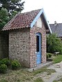
Oratory Notre Dame de la Consolation
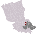
Location of Flêtre in the Arrondissement of Dunkerque and in the Canton of Bailleul
_%C3%A9glise_(02).JPG)


literature
- Le Patrimoine des Communes du Nord. Flohic Editions, Volume 1, Paris 2001, ISBN 2-84234-119-8 , pp. 178-180.
Web links
Commons : Flêtre - collection of images, videos and audio files