
District of Friesland
| coat of arms | Germany map |
|---|---|

|

Coordinates: 53 ° 31 ' N , 7 ° 59' E |
| Basic data | |
| State : | Lower Saxony |
| Administrative headquarters : | Jever |
| Area : | 607.91 km 2 |
| Residents: | 98,704 (Dec. 31, 2019) |
| Population density : | 162 inhabitants per km 2 |
| License plate : | FRI |
| Circle key : | 03 4 55 |
| NUTS : | DE94A |
| Circle structure: | 8 municipalities |
| Address of the district administration: |
Lindenallee 1 26441 Jever |
| Website : | |
| District Administrator : | Sven Ambrosy ( SPD ) |
| Location of the district of Friesland in Lower Saxony | |
  |
|
The district of Friesland is a district in the northwest of Lower Saxony . The seat of the district administration is the city of Jever .
geography
location
The district of Friesland is located in the traditional settlement area of the Frisians in East Friesland , the peninsula between the Ems and the Jade Bay (like the neighboring town of Wilhelmshaven ), but politically never belonged to East Friesland . After the fall of the Jever rule , the Jeverland , like the Frisian Wehde before it , became part of Oldenburg and is still part of the Oldenburger Land today. The district area includes the East Frisian island of Wangerooge and the Minsener Oog to the east .
The predominant landscape type is the marshland (alluvial land) , followed by geest and moor . Wall hedges in the form of walls overgrown with trees or shrubs are widespread in the landscape . They are part of the cultural landscape of Friesland and date from the Middle Ages . At that time they served to demarcate the properties, today they serve as wind protection and represent ecological small areas. Because of the location of the district directly on the North Sea, tourism plays an important role. The nine-kilometer-long island of Wangerooge in the Wadden Sea offers special attractions for holidaymakers .
Neighboring areas
The district borders clockwise to the north, starting with the Wadden Sea of the North Sea , the Jade and the Jadebusen with the independent city of Wilhelmshaven in between, as well as the Wesermarsch , Ammerland , Leer and Wittmund districts .
coast
The coast of the late 16th century is reproduced on the historical map of 1595 by the East Frisian scholar Ubbo Emmius . The sea inrushes of the Black Brack between Gödens and Varel and the Harle Bay in the Wittmund district are clearly visible .
history
Since the 19th century, the area of today's district was divided into the two offices of Jever and Varel and the unofficial cities of Jever and Varel.
As part of the Oldenburg administrative reform in 1933, the Office of Friesland was formed from the Office and the City of Jever, the City of Varel and most of the Office Varel . At the same time, most of the old municipalities of the offices of Jever and Varel were combined to form new large municipalities. On January 1, 1939, the Friesland office was renamed the Friesland district . The district became part of the newly founded state of Lower Saxony in 1946 as part of the state of Oldenburg.
The large communities formed in 1933 were again divided into smaller communities in 1948.
The regional reform in Lower Saxony began in the district of Friesland on January 1, 1971 with the merger of the communities of Hohenkirchen , Minsen and Tettens to form the new community of Wangerland . On July 1, 1972, the law on the reorganization of the municipalities in the Friesland-Wittmund area came into effect:
- The municipality of Sengwarden left the district and was incorporated into the independent city of Wilhelmshaven .
- The East Frisian community of Gödens from the district of Wittmund was incorporated into the community of Sande .
- The number of parishes in the district was reduced to eight.
The changes in the municipality structure during the territorial reforms of 1948 and 1972 are shown in the following table:
| Community structure of the district of Friesland | ||
|---|---|---|
| 1933-1948 | 1948-1971 | today |
| Frisian woe | Bockhorn | Bockhorn |
| Neuchâtel | Zetel | |
| Zetel | ||
| Jever | Jever | Jever |
| Oestringen | Cleverns sandals | |
| Sands | Sands | |
| Schortens | Schortens | |
| Kniphausen | Sillenstede | |
| Sengwarden | (to Wilhelmshaven ) | |
| Varel | Varel | Varel |
| Varel country | Varel country | |
| Wangerland | Hohenkirchen | Wangerland |
| Tettens | ||
| Minsen | Minsen | |
| Hooksiel | ||
| Waddewarden | ||
| Wangerooge | Wangerooge | Wangerooge |
As a result of the Lower Saxony district reform that came into force on August 1, 1977, the district of Friesland was dissolved and the communities of Bockhorn and Zetel and the city of Varel were reclassified into the district of Ammerland. The town of Jever and the communities of Sande, Schortens, Wangerland and Wangerooge were combined with the East Frisian district of Wittmund to form a new district of Friesland, the district town of which became Wittmund.
Due to various constitutional complaints before the Lower Saxony State Court in Bückeburg, the district reform was found to be unconstitutional in parts and a revision of the law for the Ammerland / Friesland area was suggested to the Lower Saxony state parliament. As of January 1, 1980, the reorganization of the Friesland / Wittmund area was withdrawn and the districts of Ammerland, Friesland and Wittmund were restored within the boundaries of 1977. The town of Jever has been the county seat again since then. The former East Frisian community of Gödens remained as part of Sande in the district of Friesland.
From December 2012, at the suggestion of the district administrator of the district of Friesland, Sven Ambrosy , and the mayor of Wilhelmshaven, Andreas Wagner , a very controversial debate about more intensive cooperation between the two municipalities developed. Background was u. a. the future program of the state of Lower Saxony , which assumes 75 percent of the short-term debts of the municipalities involved in the merger in the case of regional reforms. In the case of Wilhelmshaven / Friesland, the debt relief aid would have been 35 million euros for Wilhelmshaven and nine million euros for Friesland. In order to clarify the potential for savings, an expert opinion was commissioned from the independent communal joint agency for administrative management (KGSt) , which was intended to examine the financial effects of a possible merger between the city of Wilhelmshaven and the district of Friesland. The report was published in November 2013 and recommended that the city of Wilhelmshaven be encircled in the district of Friesland. Wilhelmshaven should therefore have given up its freedom of the district . However, the political leaders could not decide on this solution. In December 2013, both municipalities refused to be encircled in their respective bodies.
See also Frisian freedom , Rüstringen , Östringen (Gau) , Jever rule
Population development
| year | Residents | source |
|---|---|---|
| 1933 | 54,942 | |
| 1939 | 59,380 | |
| 1950 | 94,964 | |
| 1960 | 83,000 | |
| 1970 | 93,200 | |
| 1980 | 96,100 | |
| 1990 | 94,258 | |
| 2000 | 100,889 | |
| 2010 | 99,598 |
politics
District council
The district council of the district of Friesland has 42 elected members and the district administrator . The parties SPD / Greens / FDP and ZUKUNFT VAREL / SWG / UWG and MMW / Die Linke each form a group in the current district assembly. The last elections to the district assembly saw the following results:
- Overview of the results of past district council elections
| Political party | 11th September 2016 | September 11, 2011 | September 10, 2006 | September 9, 2001 | ||||||||
|---|---|---|---|---|---|---|---|---|---|---|---|---|
| percent | be right | Seats | percent | be right | Seats | percent | be right | Seats | percent | be right | Seats | |
| SPD | 34.3% | 46,637 | 15th | 38.2% | 49.121 | 16 | 40.9% | 47,465 | 19th | 41.8% | 53,824 | 20th |
| CDU | 24.3% | 33,089 | 10 | 24.0% | 30,778 | 10 | 27.9% | 32,423 | 13 | 28.9% | 37,303 | 13 |
| FDP | 5.4% | 7,399 | 2 | 4.6% | 5,858 | 2 | 9.6% | 11,165 | 4th | 8.5% | 10,920 | 4th |
| Green | 10.3% | 14,058 | 4th | 12.1% | 15,502 | 5 | 6.1% | 7,044 | 3 | 6.3% | 8,135 | 3 |
| UWG | 2.4% | 3,293 | 1 | 3.6% | 4,623 | 1 | 3.8% | 4,415 | 2 | 5.0% | 6,426 | 3 |
| SWG | 2.3% | 3.115 | 1 | 3.0% | 3,809 | 1 | 2.7% | 3.134 | 1 | 4.6% | 5,923 | 2 |
| BfB | - | - | - | 4.4% | 5,626 | 2 | 4.5% | 5,223 | 2 | 2.7% | 3,451 | 1 |
| The left | 2.0% | 2,732 | 1 | 1.7% | 2,244 | 1 | 1.3% | 1,543 | 1 | - | - | - |
| MMW | 2.2% | 3,031 | 1 | 2.8% | 3,630 | 1 | 3.2% | 3,767 | 1 | - | - | - |
| BBV / F | 0.8% | 1,100 | 0 | 1.4% | 1,844 | 1 | - | - | - | - | - | - |
| WFF | 2.3% | 3,105 | 1 | - | - | - | - | - | - | - | - | - |
| Future of Varel | 5.9% | 8,031 | 3 | 3.6% | 4,681 | 2 | - | - | - | - | - | - |
| AfD | 7.7% | 10,540 | 3 | - | - | - | - | - | - | - | - | - |
| voter turnout | 47,166 of 83,568 | 45,280 of 82,967 | 41,027 of 82,602 | 45,013 of 80,576 | ||||||||
| 56.4% | 54.6% | 49.7% | 55.9% | |||||||||
District Administrator
The district administrator of a district represents the district on a political level and is also head of the district administration. Since August 12, 2003 Sven Ambrosy has been the full-time district administrator for the district of Friesland. He replaced Karin Evers-Meyer as district administrator and Lothar Knippert as senior district director . Ambrosy had previously come to the Friesland district as a department manager in July 2000. From July 1, 2001, he was also deputy senior district director.
Silke Vogelbusch has been Ambrosy's general representative since January 1st, 2012. It was in November 2011 at the inaugural meeting of the County Council Friesland in Schortens as First District Councilor elected.
Furthermore, there are three equal honorary deputy district administrators for representative tasks .
Representatives in the Land and Bundestag

In the elections to the Lower Saxony state parliament , the district of Friesland forms the state electoral district 070 Friesland . The direct mandate was won in January 2013 by Olaf Lies from the SPD. He is deputy parliamentary group leader, port policy spokesman and was elected chairman of the Lower Saxony SPD in May 2010 . The electoral term ends in 2018.
In the elections to the German Bundestag , the district of Friesland belongs to the Bundestag constituency 026 Friesland-Wilhelmshaven-Wittmund . It includes the districts of Friesland and Wittmund as well as the city of Wilhelmshaven . The directly elected MP is Siemtje Möller from the SPD. Her opponent Hans-Werner Kammer from the CDU initially missed re-entry into the Bundestag in the last federal election, but was able to move up to the Bundestag on April 1, 2010 through Martina Krogmann's resignation via the CDU's Lower Saxony state list .
badges and flags
The coat of arms of the district is described as follows: "In blue a red-armored golden lion between a silver anchor cross in the right and left upper corner." The lion is a medieval symbol of rule of the chiefs of Jever, while the anchor cross was borrowed from the family coat of arms of the Counts of Bentinck, who held sovereign rights in the lords of Varel and Kniphausen until the 19th century. The coat of arms was awarded on April 26, 1962. The circular flag has horizontal blue and red stripes with a circular coat of arms. Blue and red are the Oldenburg national colors.
LiquidFriesland
The district of Friesland is the first municipality in Germany in which active citizen participation is possible online via the LiquidFriesland project . The LiquidFeedback software used for this was activated on November 9, 2012. At the end of April 2016, the barely used platform was switched off. In December 2016, the district of Friesland published a revised online platform with the same name, on which citizens can send their suggestions directly to the district of Friesland.
economy
In the Future Atlas 2016 , the district of Friesland was ranked 224 out of 402 districts, municipal associations and independent cities in Germany, making it one of the regions with a “balanced risk-opportunity mix” for the future.
The GDP per capita in 2015 was 26,419 euros (Lower Saxony average: 32,591 euros)
Institutions
The Oldenburg Landscape , a registered body under public law, is responsible for maintaining and promoting cultural and historical concerns in the old Oldenburg region . This is also a member of the East section of the Inter-Frisian Council for the area of the district . The landscape has its seat in the city of Oldenburg.
Archaeological monuments in the Friesland district
- Canarienhausen Castle near Waddewarden
- Christiansburg near Varel
- Village Wurt -savers Lerns
- Ellenser dam
- Ellenserdamm fortress
- Friederiken Vorwerkdeich
- Schortens burial mound field
- Jedutenhügel near Rotenhahn (Varel)
- Fortified church in Jever
- Kirch wurt Sillenstede
- Oestringfelde Monastery
- Motte at the Lindern monastery courtyard
- Jever Castle
- Turn around
- City fortifications of Jever
- Moated Castle of Gödens
- Woltersberg near Jever
Jewish cemeteries in the district of Friesland
There are four Jewish cemeteries in the Friesland district : in Hohenberge , a district of Varel , in Jever , in Neustadtgödens and in Schortens . They are protected cultural monuments - stone witnesses to formerly existing Jewish communities and a lively Jewish community life up to the 1930s. The cemeteries are usually difficult to find, especially since they are mainly on the outskirts of the communities.
traffic

The Prussian State Railways connected the important naval port of Wilhelmshaven via Sande - Varel with the royal seat of Oldenburg (Oldenburg) since 1867 .
In Sande, from 1871, a line of the Oldenburg State Railroad to the district town of Jever was connected, which was continued in 1883 to Wittmund, Esens and finally via Dornum to the north .
In Jever , a railway to Harle , the starting point of the ship line to the island of Wangerooge, had been branching off from the Erlanger & Söhne bank in Frankfurt am Main since 1888 . There the Oldenburg State Railway put a meter-gauge island railway into operation in 1897.
From the main line Oldenburg (Oldb) - Wilhelmshaven , further branch lines started in 1893: From Ellenserdamm it went south in the direction of Grabstede and in 1905 on to Westerstede. The line branching off from Varel crossed in Bockhorn and continued to Zetel in 1894 and to Neuchâtel in 1896; from there the branch line Borgstede - Bramloge branched off . The cross-connection between Varel and Rodenkirchen was established in 1913.
This means that a state railway network of 110 km was used by passenger trains on the mainland. Over half of them were shut down after the Second World War:
- 1954: Ellenserdamm - Bockhorn - Grabstede - Ocholt: 15 km;
Varel - Borgstede - Zetel - Neuchâtel: 19 km and
Borgstede - Bramloge: 4 km - 1958: Varel - Hohenberge - Rodenkirchen: 22 km
- 1987: Jever - Carolinensiel - Harle: 20 km
The entire passenger traffic on the mainland is now in the hands of NordWestBahn GmbH. With the exception of the Wangerooger Inselbahn , Deutsche Bahn has completely withdrawn from the district.
The district of Friesland is located in the catchment area of the federal highway A 29 and the federal roads 210 , B 436 and B 437 .
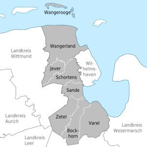
Communities
|
The number of inhabitants on December 31, 2019 in brackets.
|
  |
Protected areas
In addition to landscape protection areas and natural monuments, there are nine designated nature reserves in the district (as of February 2017).
See also:
- List of nature reserves in the district of Friesland
- List of landscape protection areas in the district of Friesland
- List of natural monuments in the district of Friesland
- List of protected landscape components in the district of Friesland
License Plate
On July 1, 1956, the district was assigned the distinctive sign JEV when the vehicle registration number that is still valid today was introduced . On April 5, 1978, the district received the new identifier FRI . This is still issued today.
Web links
Individual evidence
- ↑ State Office for Statistics Lower Saxony, LSN-Online regional database, Table 12411: Update of the population, as of December 31, 2019 ( help ).
- ↑ Oldenburg law for the simplification and cheaper administration of April 27, 1933.
- ^ Law on the formation of new communities in the Lower Saxony administrative district of Oldenburg of April 26, 1948.
- ↑ Wolfgang Becker: Something completely paradoxical. SPIEGEL editor Wolfgang Becker on the regional reform in Friesland . In: Der Spiegel . No. 23 , 1977, pp. 89-90 ( Online - May 30, 1977 ).
- ^ KGSt report on cooperation between the city of Wilhelmshaven and the district of Friesland , accessed on December 30, 2013.
- ↑ jeversches-wochenblatt.de: encirclement rejected unanimously , accessed on December 25, 2013.
- ^ A b c d Michael Rademacher: German administrative history from the unification of the empire in 1871 to the reunification in 1990. friesland.html. (Online material for the dissertation, Osnabrück 2006).
- ↑ Statistical Yearbook for the Federal Republic of Germany 1972 .
- ↑ Statistical Yearbook for the Federal Republic of Germany 1981 .
- ↑ a b c Lower Saxony regional database .
- ↑ a b c d District of Friesland: Your district council , accessed on December 25, 2016
- ↑ Landkreis Friesland - Der Landrat , accessed on January 27, 2013.
- ↑ Silke Vogelbusch becomes district councilor in Friesland , accessed on January 27, 2013.
- ↑ Düsseldorferin in der Kreisspitze , accessed on January 27, 2013.
- ↑ Constituency allocation by the Federal Returning Officer , accessed on April 20, 2019.
- ^ Chamber returns to Berlin , accessed on November 5, 2011.
- ↑ Landkreis Friesland: coat of arms and flag ; Retrieved February 21, 2010.
- ^ LK Friesland ; Retrieved February 21, 2010.
- ↑ LiquidFriesland - project description, linked as PDF in the middle of the picture. District of Friesland, accessed on January 27, 2013 . .
- ^ Friesland district: Liquid Friesland - media reports .
- ^ Wilhelmshavener Zeitung: "Quite inconspicuously buried". Policy expert on "LiquidFriesland", page 13.
- ^ Liquid Friesland , accessed on December 25, 2016
- ↑ Future Atlas 2016. (No longer available online.) Archived from the original on October 2, 2017 ; accessed on March 23, 2018 .
- ^ State Statistical Office of Baden-Württemberg: Current results - VGR dL. Retrieved March 27, 2018 .
- ^ University of Heidelberg: Section Friesland District . In: Jewish cemeteries according to the current administrative structure - Lower Saxony. In: Overview of all projects for the documentation of Jewish grave inscriptions in the area of the Federal Republic of Germany. .
- ↑ State Office for Statistics Lower Saxony, LSN-Online regional database, Table 12411: Update of the population, as of December 31, 2019 ( help ).
Counties : Ammerland | Aurich | Celle | Cloppenburg | Cuxhaven | Diepholz | Emsland | Friesland | Gifhorn | Goslar | Göttingen | County of Bentheim | Hameln-Pyrmont | Harburg | Heidekreis | Helmstedt | Hildesheim | Holzminden | Empty | Lüchow-Dannenberg | Lüneburg | Nienburg / Weser | Northeim | Oldenburg | Osnabrück | Osterholz | Peine | Rotenburg (Wümme) | Schaumburg | Stade | Uelzen | Vechta | Verden | Wesermarsch | Wittmund | Wolfenbüttel
Region : Hanover
Independent cities : Braunschweig | Delmenhorst | Emden | Oldenburg (Oldb) | Osnabrück | Salzgitter | Wilhelmshaven | Wolfsburg