
Cultural area


Cultural area (from Latin arealis "area"), cultural complex or cultural province describes in ethnology a geographically delimited area in which different ethnic groups live, which have a certain number of typologically similar or comparable cultural elements or cultural assets . The reasons for this are homologous developments through common ancestry, cultural transfer between neighboring ethnic groups and (much more controversial discussion) analogous agreements that are attributed to similar living conditions.
The non-European cultural complexes in areas of former European colonies refer generally to ideas of a recent historical distribution and way of life of "indigenous" peoples before the colonization and before the formation of the modern nation-states. The cultural areas of Europe are an exception: although they refer explicitly to historical development, they nonetheless depict realities that are still true today. The same applies, to a limited extent, to most areas of South Asia.
Many traditional ways of life and indigenous cultural elements only exist today as a substrate under the prevailing culture, so that cultural area maps for the present in many regions of the world highlight the cultural minorities. For example, the North American prairie and plains cultural area refers to the prairie Indian peoples ; they still live there, although their share of the population is only around three percent and they have not been living from traditional bison hunts since the middle of the 19th century.
Modern ethnology introduced the term cultural area after the " culture circle theory " was abandoned because it was associated with the racial ideology of the Third Reich. The concept of the culture area developed by the American ethnologists Franz Boas , Robert Lowie and Clark Wissler was later adopted by various authors.
The models of the cultural areas are based on the out-of-Africa theory as well as the genetically reconstructed human spread and the “migratory behavior” of human populations . It is assumed that small, prehistoric groups have spread over the earth due to inhospitable living conditions and / or the exhaustion of resources. Settlement took place in favorable areas and, over time, an ever better adaptation to the respective ecological conditions. This is how the oldest cultures came into being. The efficient use of the environment in turn led to a strong increase in population and thus to a star-shaped expansion and establishment of cultures within the respective large habitat . According to the theory, the essential characteristics of the cultures were retained. With the "offshoots" there was only a differentiation of details. Against this background, it is possible to define spatially delimitable cultural areas.
Outside of the ethnological and historical sciences, one speaks of cultural areas or cultural parts of the earth , which depict the current situation in the respective context of their specialist area.
Problem of demarcation
.jpg)

Any definition of a cultural area is based on the results of cross- cultural social research from a one-sided European perspective . While the demarcation between a few cultures is relatively easy, dividing entire continents into demarcated areas is difficult and problematic: the maps drawn by different authors at different times often do not agree with one another; they show unequal numbers, sizes and boundaries of the individual cultural areas. This is mainly due to the very arbitrary selection of those cultural elements that were and will be seen as characteristic of a certain cultural area. In addition, there is constant cultural change in many areas of the world.
The greatest difficulty in the delimitation is the determination of which cultural assets are actually specific to an area and which apply across multiple cultures. Cultural goods in this sense are, for example, language, art forms, family structures, social organization, calendars, body decorations, folklore, forms of living, modes of subsistence ; hence the ideological systems of a culture. The ecological conditions of the respective habitats also form an essential basis for continental models.
Although the definition of cultural areas is controversial today for the reasons mentioned, it offers the possibility of structuring cultural diversity and creating a basis for cross-cultural studies. The division into cultural areas is a heuristic tool, an auxiliary thought (bon à penser) in the sense of the French ethnologist Claude Lévi-Strauss .
In this sense, the correspondences between the various (historical) authors, despite the aforementioned objections, are again large enough to combine all models into a "world model of cultural areas", as D. Hunter and P. Whitten in 1976 for the "Encyclopedia of Anthropology" have formulated.
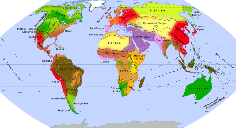
Cultural areas of the earth: mirror image of the vegetation zones and traditional land use
The 43 “Culture Areas of the World” by Hunter and Whitten are based on the theory that culture is primarily a mechanism for mutual adaptation to different living spaces. They formulated the following definition:
“A cultural area is a definable part of the earth's surface in which more or less related groups of people live, for whom the adaptation process over millennia has led to a great variety of survival strategies; but based on a common heritage: similar ecological conditions, similar economic, social and ideological systems as well as related languages. "
With a few exceptions, the areas therefore coincide with the relevant global vegetation zones (see map: The Earth's Vegetation Zones ) . In relation to the economic forms that have arisen there, the model can also be viewed as a schematic map of traditional land use on earth.
The authors explicitly point out that the borders are not specific indigenous territories, but only schematically drawn borders to mark the interfaces between the cultures that flow into one another. In this sense, only the cultural differences between the respective centers of the areas are significant, not those on either side of the borders!
Moreover, the authors admit the problems of delimitation and described the selection of the criteria used from the multitude of ethnographic records as (to a large extent) arbitrary.
The following map with the following tables of the keywords (often historical) cultural elements correspond to the description of Hunter and Whitten in the Encyclopedia of Anthropology . The authors differentiate between three levels of scale : Above the cultural areas are the "main areas", which are reminiscent of the division into " cultural parts of the earth " by the German geographer Albert Kolb or the map of the "civilizations" by Samuel P. Huntington . Some areas are further broken down into “sub-areas”.
| Agriculture, pastoral nomadism and long-distance trade | sedentary, nomadic and semi-sedentary |
| Soil construction and long-distance trade | sedentary |
| Traditional agriculture | sedentary |
| Agriculture, horticulture and grassland farming | sedentary |
| Land change construction | sedentary |
| Shifting cultivation | semi-sedentary |
| Horticulture, shifting farming, and hunting or fishing | mostly semi-settled |
| Transhumance and soil construction | Soil farming is sedentary, livestock farming is semi-sedentary |
| Agropastoralism | sedentary, semi-sedentary or semi-nomadic |
| Specialized collection economy | mostly semi-settled |
| Specialized hunting or fishing | Sedentary fishing, semi-nomadic hunting |
| Reindeer nomadism | semi-nomadic |
| Pastoral nomadism | nomadic, partly semi-nomadic |
| Unspecialized hunting, fishing and foraging | nomadic, fishing semi-nomadic |
Main area of North America
- → compare: North American cultural areas according to Wissler and Kroeber
| Cultural area | Habitat and (historical) similarities | Ethnic groups (examples) |
|---|---|---|
| Arctic | Tundra : semi-sedentary foragers (caribou, musk ox, seasonal fishing and marine mammals), acephalic communities , winter settlements often on the coast, common Eskimo-Aleut languages | Inuit , Yupik , Kalaallit , Inupiat , Alëuten , Eskimo |
| Northwest coast | Coastal rainforest : sedentary hunters (marine mammals) and fishermen (salmon); Chiefs with large populations, special social institutions ( slavery , potlatch - "giveaway festival"), art style | Tlingit , Haida , Tsimshian , Kwakiutl , Chinook |
| Subarctic |
Northern sub-area forest tundra u. boreal mountains: semi-nomadic hunters (caribou), fishermen and gatherers (berries); egalitarian hordes |
Kutchin , Kaska , Athabascan tribes , Naskapi |
|
Southern subarea Taiga : nomadic hunters (elk, elk, small game), fishermen and - z. Partly semi-settled - collectors (various plants, berries, wild rice); egalitarian hordes |
Cree , Anishinabe , Menominee , Algonquin , Innu | |
| Plateau Basin California |
Subareal Plateau dry plateau in the Rockys : semi-nomadic salmon fishermen, hunters and gatherers (roots, bulbous plants); Tribal societies |
Ktunaxa , Spokane , Yakama , Secwepemc |
|
Subareal Large Basin Semi -deserts : nomadic gatherers (acorns, pinyon nuts, seeds, berries, roots) and hunters (pronghorn, small animals); egalitarian hordes |
Shoshone , Paiute , Washoe | |
|
California subarea Hard deciduous forests , dry steppe, Mediterranean forests: semi- sedentary gatherers (wild fruits, especially acorns, nuts) and hunters (small animals, sea animals); egalitarian hordes or tribal societies |
Modoc , Caliph. Penuti , Yana , Pomo , Cahuilla | |
| Wide level | Grass, shrub and dry steppes : semi-nomadic, mounted hunters ( prairie bison , pronghorn ), until the 18th century often semi-sedentary horticulture; Tipi (tent), tribal societies | Blackfoot , Cheyenne , Crow , Lakota , Comanche |
| east |
Subarea northeast deciduous mixed forests : semi - sedentary slash-and - burn agriculture (maize, beans, pumpkins), also wild rice harvest and hunting; egalitarian clan confederations |
Illinois , Iroquois , Abenaki , Miami , Shawnee |
|
Subareal Southeast Subtropical wet forests and Deciduous mixed forests: mostly sedentary, intensive farming : (maize, beans, pumpkins) and hunting; Chiefs, solid palisade-reinforced settlements |
Creek , Choctaw , Natchez , Cherokee , Chickasaw | |
| southwest |
Subareal Pueblo Indians semi-deserts and arid plateaus: sedentary agriculture , e.g. T. irrigation (corn, beans, pumpkins) and small animal hunting; stratified clan confederations, relatively dense villages |
Hopi , Havasupai , Tarahumara , Zuni , Yaqui |
|
Subarea Navajo u. Apache semi-deserts a. arid plateaus: nomadic hunters (bison, pronghorn, small animals) and gatherers ( agaves , nuts, seeds), robbery, semi-nomadic agriculture (corn, beans, pumpkins) or later sheep breeding, egalitarian hordes |
Apaches , Navajo | |
| Mesoamerica | Dry and humid subtropical u. tropical biomes: various sedentary and semi- sedentary soil types (corn, beans, pumpkins) and small animal hunting; theocratic states , "cultural followers" of the historical high cultures of Central America | Toltecs , Aztecs , Maya , Tarascan , Huichol |
Main area South America
- → compare: Indigenous cultural areas according to Münzel
| Cultural area | Habitat and (historical) similarities | Ethnic groups (examples) |
|---|---|---|
| Caribbean | Tropical savannas and wet forests : semi-sedentary hunting (small animals), fishing, horticulture (papaya, guava, avocado) and slash-and-burn agriculture (cassava); often chiefdoms | Arawak , Caribs |
| Chibcha | Tropical lowland u. Mountain rainforests: mostly sedentary farming (corn, beans, pumpkins, cassava, potatoes); often chiefdoms, influences from high civilizations in the north and south | Chibcha , Kuna , Embera , Paez , Ika , Wiwa , Kogi |
| To the | Andean highland steppes: sedentary crop rotation - agriculture and irrigation terraces (potatoes, as well as enormous crop diversity); theocratic states inca tradition | Quechua , Aymara , Kolla , Huanca , Atacameño , Inca , |
| Amazonia | Tropical rainforests : mostly semi-sedentary horticulture (papaya, guava, avocado), shifting cultivation (manioc), hunting and fishing; egalitarian groups or chiefdoms, frequent conflicts with neighboring groups | Huaorani , Shuar , Yanomami , Ticuna , Munduruku |
| Brazilian highlands | Tropical savannas: semi-sedentary slash-and-burn farming (cassava), hunting and fishing; Tribal societies | Xavante , Xerente , Karajá , Guaraní |
| Chaco | Tropical dry forests: semi-sedentary fruit collectors, later horse warriors, fishing, little shifting cultivation ; egalitarian groups or tribal societies | Wichí , Guaycurú , Toba , Chiriguano , Ayoreo |
| Araucania | temperate deciduous and coniferous forests: semi-sedentary farming (maize, beans, potatoes), gathering ( araucarias ) and hunting, cavalry warriors; egalitarian hordes | Mapuche , Picunche , Huilliche |
| Patagonia | dry, temperate open landscapes: semi-nomadic hunters (guanaco and rhea, later cattle and horses, marine mammals) and gatherers (seafood), cavalry warriors, local agriculture (wheat, potatoes); egalitarian hordes | Tehuelche , Het , Puelche |
| fire land | temperate coastal rainforests, Magellanic tundra : nomadic hunters (guanaco, crested rat), fishermen (sea creatures) and gatherers (roots, mushrooms, berries), minimal horticulture; egalitarian hordes | Selk'nam , Yámana , Chonos |
Main area in Europe
- → compare: Historical regions of Europe according to Christian Giordano
| Cultural area | Habitat and (historical) similarities | Ethnic groups (examples) |
|---|---|---|
| Northwest Europe | Atlantic moist deciduous and coniferous forests of the temperate latitudes : sedentary agriculture (grain), horticulture (fruit, vegetables) and grassland farming (cattle, pigs); Nation states , "culture follower" of medieval feudal states , origin of industrial society | England , France , Germany , Sweden |
| Eastern Europe | continental dry deciduous, mixed and coniferous forests of the temperate latitudes: sedentary agriculture (grain); Nation-states, shaped by the unsteady migration period , agricultural states | Poland , Hungary , Romania , Russia , Ukraine |
| Southern Europe | Mediterranean hard-leaf vegetation: sedentary agriculture (grain), permanent cultivation (olives, tropical fruits) and semi- sedentary long-distance trade (Mediterranean); Nation states, "cultural followers" of ancient high cultures | Portugal , Spain , Italy , Serbia , Greece |
| Caucasia | subtropical and temperate mountain forests: semi-sedentary transhumance (sheep, cattle, horses) and soil structure (grain); Nation states, “melting pots” with a great variety of languages and cultures | Georgia , Azerbaijan , Armenia |
Main area in the Middle East
| Cultural area | Habitat and (historical) similarities | Ethnic groups (examples) |
|---|---|---|
| Southwest Asia | hot deserts and semi-deserts, fertile valleys: sedentary agriculture (wheat), nomadic shepherds (camels, sheep, goats, horses) and semi- sedentary long-distance trade (Mediterranean, trade caravans ); Islamic caliphates , “symbiosis” of farmers, traders and Bedouins | Turkey , Persians , Kurds , Arabs ( Iraq , Saudi Arabia , Egypt ) |
| North Africa |
Subareal Mediterranean coast Hard foliage vegetation and Semi-deserts: sedentary agriculture (grain), permanent cultivation (olives, tropical fruits) and semi-sedentary long-distance trade (Mediterranean); Caliphates, "cultural followers" of ancient high cultures |
Arabs ( Moroccans , Tunisians , Libyans ) and Berbers |
|
Subareal inland hot semi-deserts and deserts: semi-nomadic transhumance (sheep, goats, cattle) and soil cultivation (grain, dates); Tribal societies |
Berber , Sanūsīya | |
| Sahara | hot deserts and semi-deserts: nomadic shepherds (camels, horses, goats), caravan trade, e.g. T. oasis culture (dates); Tribal societies | Tuareg , Tubu , Mauritanians |
| Horn of Africa | tropical savannahs and highland steppes: semi-sedentary or nomadic agropastoralism ( teff , sorghum , ensete / cattle), e.g. T. sedentary agriculture (grain); Clan systems in states, great influence of Southwest Asia | Somalis , Oromo , Amharen , Tigray |
Main area in Africa
| Cultural area | Habitat and (historical) similarities | Ethnic groups (examples) |
|---|---|---|
| West Sudan | Dry , thorn shrub u. Moist savannahs : sedentary land change (sorghum, sweet potato ) with cattle pastoralism ; "Cultural followers" of the pre-colonial kingdoms, chiefdoms | Fulbe , Songhai , Fur , Hausa , Yoruba , Kanuri |
| Guinea | Tropical rainforests and wet forests: permanent sedentary farming (cassava, yams , taro , permanent crops), trade and fishing; "Cultural followers" of the pre-colonial kingdoms, chiefdoms | Yoruba , Ewe , Fon , Ashanti , Akan , Edo , Igbo |
| Congo |
Bantu sub-area tropical forests and Savannas: semi-sedentary shifting cultivation (cassava, taro , sorghum), hunting, fishing, collecting, pig or cattle farming; Chiefdoms or tribal societies |
Azande , Mongo , Baluba , Lunda , Bemba |
|
Pygmy subarea Tropical rainforest: nomadic hunters (mammals, birds) and gatherers (mushrooms, honey, larvae, fruits); egalitarian hordes |
Mbuti, Mbenga, Efe, Cwa, Gieli, Twa , Baka | |
| Eastern highlands | Tropical savannahs: semi-nomadic transhumance (especially cattle as well as sheep, goats), sedentary land change (sorghum, sweet potato), hunting, gathering and fishing; Tribal societies | Dinka , Nuer , Massai , Samburu , Luo , Turkana |
| South plateau | Miombowald , savannah u. Steppe: sedentary, semi-sedentary or nomadic agropastoralism (sorghum, cattle); Chieftains, tribes, or royalty | Ovambo , Herero , Ovimbundu , Xhosa , Zulu |
| South West Africa |
Khoikhoi -Subareal Hot semi-deserts: semi- sedentary or nomadic agropastoralism (sorghum, cattle, sheep), hunting and gathering; Clan system |
Nama , Orlam |
|
San -Subareal hot deserts and semi-deserts, thorn savannahs : nomadic hunters (mammals, birds, reptiles) and gatherers (nuts, roots, berries); egalitarian hordes |
Ju|'hoansi, !Kung , Damara |
Main area of Northern Asia
| Cultural area | Habitat and (historical) similarities | Ethnic groups (examples) |
|---|---|---|
| Siberia |
Northern sub-area tundra , forest tundra, etc. Taiga : nomadic reindeer pastoralism , hunters (land and marine mammals, fish) and gathering (berries); egalitarian groups |
Seeds , Nenets , Chanting , Evenks , Evens , |
|
Southern subarea forest steppe , temperate deciduous forests u. Taiga: sedentary or semi-sedentary cattle breeding (horses, cattle, sheep, reindeer) and some soil cultivation (hay, grain); Khanates , estates |
Buryats , Yakuts , Khakass , Altaians , Tuvins | |
| Paleo Siberia | Tundra u. Forest tundra: sedentary or semi-sedentary hunters (reindeer, marine mammals, fish); egalitarian groups | Chukchi , Koryaks , Jukagirs , Itelmens |
| Eurasian steppe |
Northern subarea Wald- u. Grass steppes: sedentary grassland farming (cattle, horses, pigs) and arable farming (grain); Khanates, estates, tribal confederations |
Tatars , Bashkirs |
|
Southern subarea steppes, winter-cold semi-desert and Desert: Shepherd nomads (horses, cattle, sheep, camels); Khanates, estates, tribal confederations |
Kalmyks , Kazakhs , Uzbeks , Mongols |
Main area South Asia
| Cultural area | Habitat and (historical) similarities | Ethnic groups (examples) |
|---|---|---|
| South Central Asia |
Subareal Indian west coast semi-deserts, dry savannahs, etc. tropical wet forests: sedentary agriculture (rice, millet, wheat), dairy farming and long-distance trade; Nation- state with caste system , "cultural follower" of the Indus culture |
Punjabis , Gujarati , Bev. Western Ghats u. Rajputs |
|
Subareal Gulf of Bengal Dry u. humid tropical u. subtropical forests and Savannah: sedentary agriculture ( wet rice , sweet potato); Caste nation state , Chinese influence |
Tamils , Bev. Central u. East India, Burmese | |
|
Subarea "Tribal Peoples" Dry u. humid tropical u. subtropical forests and Savannas: semi-sedentary shifting cultivation (rice, millet, vegetables), hunting (mammals, birds) and collecting (wild fruits); egalitarian groups or chiefdoms |
Vedda , Adivasi , Derung , Andaman , Mlabri | |
|
Subareal Himalaya u. Tibet highland steppes a. -deserts, high mountain vegetation: shepherd nomads (yaks, horses, goats, donkeys), soil cultivation in the valleys (barley, vegetables, fruit); Buddhist theocracy, social order |
Tajiks , Tibetans , Nepalese , Lepcha , Lhoba | |
| North China | Temperate forests, steppes and deserts: sedentary agriculture ( buckwheat , millet, soy) and livestock (pigs, cattle, sheep); Nation-state, "cultural successor" of the historical empires | Han Chinese , Hui Chinese , Manchu |
| South china | Subtropical u. tropical wet forests, mountain forests, savannas: soil cultivation (wet rice, millet, soy, yams, taro) horticulture (vegetables, citrus fruits, coconuts) and cattle breeding (pigs, chickens); Nation states, "cultural successors" of the historical empires | South Chinese ethnic groups , Vietnamese , Khmer |
| Korea and Japan |
Younger Subareal Moderate u. subtropical forests, mountain forests: agriculture (rice, taro) and fishing (seafood); Nation states, "cultural followers" of historical empires |
Koreans , Japanese |
|
Older sub-area moderates u. boreal deciduous a. Coniferous forests: sedentary fishermen (seafood), hunters (birds, small animals) and gatherers (wild plants); egalitarian groups |
Ainu | |
| Indonesia |
Younger subarea Tropical rainforests, savannas, etc. Dry forests: sedentary or semi-sedentary horticulture ( sago , banana), shifting cultivation (wet rice, taro, sweet potato), hunting and fishing; autonomous ranking societies in states |
Malay , Javanese , Dusun , Filipino , Malagasy |
|
Older subarea Tropical rainforests: nomadic hunters (mammals, birds), fishermen and gatherers (wild plants, roots, sago); egalitarian clan societies |
Semang , Senoi , Aeta , Penan |
Main area of Oceania
- → compare: Aboriginal cultural areas according to Nicolas Peterson
| Cultural area | Habitat and (historical) similarities | Ethnic groups (examples) |
|---|---|---|
| Micronesia | Tropical island vegetation: fishing, long-distance trade, horticulture (coconut, taro, yams, bananas) and livestock (pigs, chickens); Chiefdoms | Micronesians : u. a. Palauer , Yap Islander |
| Melanesia |
Younger subarea Tropical rainforests: semi- sedentary horticulture ( sago , banana, pandanus fruits ), shifting agriculture (yams, taro, sweet potatoes), cattle breeding (pigs, chickens) and fishing; egalitarian groups |
Papuan peoples , Melanesians : u. a. Tolai , Solomon |
|
Older subarea Tropical mountain rainforests: semi-nomadic hunters (mammals, birds), horticulturists (sago, banana, pandanus) and gatherers (wild plants, roots, honey); egalitarian groups |
Korowai , Meakambut | |
| Polynesia | Tropical, subtropical u. temperate island vegetation: sedentary soil cultivation (taro, sweet potato, breadfruit ), cattle breeding (pigs) and fishing; pre-state chiefdoms | Polynesians , etc. a. Maori , Hawaiians, Easter Islanders |
| Australia | Subtropical u. tropical dry rooms, e.g. T. Forests: nomadic hunters (marsupials, birds, reptiles) and gatherers (wild plants); egalitarian hordes | Aborigines : u. a. Arrernte , Yolngu , Warlpiri , Tiwi , Tasmanians |
See also
- The HRAF project (cross-cultural Human Relations Area Files )
- Distribution areas of the African religions according to "cultural provinces"
- Criticism of the concept of the “settlement archaeological cultural provinces” by Gustaf Kossinna
- Cultural boundary (cultural divide) · Language boundary
- European cultural area · Arab world · China (cultural area in East Asia) · Latin America
- Cultural landscape (biological)
- Racial theory
literature
- David E. Hunter, Phillip Whitten (Eds.): Encyclopedia of Anthropology. Harper and Row, New York et al. 1976, ISBN 0-06-047094-1 , keywords: “Culture Area” p. 104, “Culture Areas of the World” p. 104–111.
- Dieter Haller : Dtv-Atlas Ethnologie. 2nd, completely revised and corrected edition. dtv, Munich 2010, ISBN 978-3-423-03259-9 .
- Egon Renner: On the origin, development and function of the term “culture area”. In: Magazine for American Studies. No. 1, Publishing House for American Studies, Wyk auf Foehr 1998.
Web links
- Elke Mader: The “culture area approach” (Latin America). In: latein Amerika-studien.at: Cultural and Social Anthropology of Latin America - An Introduction. Latin America Studies Online, February 2012, accessed on April 9, 2014 (the author is a lecturer at the Institute for Ethnology, Cultural and Social Anthropology, University of Vienna).
Remarks
- ↑ Unclear or missing assignments were supplemented in comparison with the Vegetationszonen.png map and the TaschenAtlas Völker und Sprachen by Willi Stegner (Ed.), Klett-Perthes, Gotha 2006.
- ↑ Sparse information from Hunter et al. Whitten adds, after Wolfgang Lindig and Mark Münzel: The Indians. Volume 2: Central and South America. 3. Edition. dtv Wissenschaft, Munich 1985.
Individual evidence
- ↑ Michel Panoff, Michel Perrin (ed.): Pocket dictionary of ethnology. Introductory terms and definitions. 3rd, revised edition. Reimer, Berlin 2000, ISBN 3-496-02668-5 , pp. 144-145 (French original: Dictionnaire de l'ethnologie ).
- ^ Christian Giordano: Interdependent diversity: The historical regions of Europe. In: Karl Kaser u. a. (Ed.): Europe and the borders in the head. Wieser-Verlag, Klagenfurt 2003, pp. 113-134.
- ↑ cultural area. In: Brockhaus - Encyclopedia in 30 volumes. 21st edition. In: Munzinger Online . 2013 (updated with articles from the Brockhaus editorial team; view subject to registration , retrieved from Wuppertal City Library on September 17, 2013).
- ^ Thomas K. Schippers: The Fractal Nature of Borders and its Methodological Consequences for European Ethnologists. In: Acta Ethnologica Danubiana. Volume 2–3, Forum Minority Research Institute, Lilium Aurum, Dunajská Streda 2000–2001, pp. 173–179, here p. 175 (English; PDF file; 435 kB, 10 pages ( Memento from December 3, 2013 on the Internet Archives ) in niton.sk ).
- ↑ see literature: Encyclopedia of Anthropology.