Lorch (Rheingau)
| coat of arms | Germany map | |
|---|---|---|

|
Coordinates: 50 ° 3 ' N , 7 ° 48' E |
|
| Basic data | ||
| State : | Hesse | |
| Administrative region : | Darmstadt | |
| County : | Rheingau-Taunus district | |
| Height : | 79 m above sea level NHN | |
| Area : | 54.53 km 2 | |
| Residents: | 3798 (Dec. 31, 2019) | |
| Population density : | 70 inhabitants per km 2 | |
| Postal code : | 65391 | |
| Primaries : | 06726, 06775 (Espenschied, Wollmellung) | |
| License plate : | RÜD, SWA | |
| Community key : | 06 4 39 010 | |
| LOCODE : | DE LOC | |
| City structure: | 5 districts | |
City administration address : |
Markt 5 65391 Lorch |
|
| Website : | ||
| Mayor : | Ivo Reßler (independent) | |
| Location of the city of Lorch in the Rheingau-Taunus district | ||
Lorch is a town in the Rheingau in the Rheingau-Taunus-Kreis in Hesse . The place is characterized by viticulture and tourism . It is part of the Upper Middle Rhine Valley World Heritage .
geography
Geographical location
Lorch is located in the far west of the Rheingau-Taunus district at the confluence of the Wisper into the Rhine and is the westernmost municipality in Hesse. The village is located on the north-western foothills of the Rheingau Mountains , about ten kilometers north of the Rhine bend at the Binger Loch . Rhine the urban area ranging from the main town on the Bächergrund and Bodental with there applied in slope camping Zulica up to the steep slopes of Teufelskadrich , of the end of the Taunus main ridge marked, almost to Spies stream at about Rheinkilometer 534.5. Down the Rhine, the urban area extends as far as the Niedertal on the border with Kaub in Rhineland-Palatinate at Rhine kilometer 544, where the lowest point in Hesse is the Rhine water level at 71.1 meters. The picturesque location in the Rhine Valley halfway between Rüdesheim am Rhein and Sankt Goarshausen is characterized by an expansion of the otherwise very narrow Middle Rhine Valley with the protected island of Lorcher Werth and the mouth of the Wisper in the center. The district area extends into the wooded Wispertal along the L 3033 between Lorch and the district town of Bad Schwalbach . The steep slopes and extensive forests in deeply indented valleys characterize the landscape around Lorch. The highest point is the Hinterloh north of Espenschied near the state border with about 465 meters. The city is a state-approved resort .
Neighboring communities
Neighboring communities, starting in the north, are Kaub , Sauerthal , Dörscheid (community forest ), Lipporn , Welterod (all five in the Rhein-Lahn district ), Oestrich-Winkel , Geisenheim , Rüdesheim am Rhein , and Trechtingshausen , Niederheimbach , Oberdiebach and Bacharach to the left of the Rhine (all four in the Mainz-Bingen district ).
City structure
In addition to Lorch, the city also includes the districts of Lorchhausen , Espenschied , Ransel , Ranselberg and Wollmigart .
history
The area was settled early on, first by the Celts , then by Ubiern and later by Mattiakern since the turn of the century . In the 1st century the Romans advanced as far as the Taunus . The Romans were followed by the Alemanni and with the Great Migration the Franks .
The oldest written evidence of the city of Lorch is a document from 1085 ( Lorecha ). Archbishop Wezilo certifies that the Mainz cathedral canon Embricho gave the cathedral chapter a number of goods, including a house and vineyards in Lorch.
The southern end of the Rheingau Gebück , a landwehr built out of bushes by the Archbishops of Mainz , had been near Lorch since the 12th century . see also Trutzburg Blideneck
In the 13th century a parish was established in Lorch , which was first mentioned in a document in 1254.
In the years 1460, 1631, 1794 and in the final phase of the Second World War , acts of war broke out in Lorch, some of which caused considerable damage.
In the 19th century Lorch came to the Kingdom of Prussia and was part of the province of Hessen-Nassau .
It was not until 1885 that Lorch was promoted to town, although it was fortified with walls and towers as early as the 13th century and thus important prerequisites for the granting of town charter were given.
On January 10, 1919, the Bottleneck Free State was proclaimed, a provisional state formation between the Allied zones of occupation. Even today, numerous coats of arms of the mini-state in the city area remind of this time.
During the Nazi dictatorship, 31 foreign forced laborers ("Eastern workers") were housed in Lorch who were forced to work in the local Degussa plant; In March 1945, up to 1,100 forced laborers were used to dig anti-tank trenches for a few days.
At the beginning of the 1960s, the Bundeswehr moved in with its anti-aircraft regiment 5 . The Ranselberg settlement was built for soldiers and their families. The Rheingau barracks located in the Wisper Valley was an important economic factor for the city, as many residents worked in the barracks, the associated site administration, and in the ammunition, equipment and medical depot.
In the course of the Bundeswehr reform, the barracks were closed in 1993. The main underground equipment depot Lorch-Wispertal and the also underground medical main depot Lorch-Rheingau remained at the site . In November 2003, the German Armed Forces announced that it would completely give up the Lorch site. On December 31, 2007, the main medical depot was closed, the medical company closed in mid-2008 and the main equipment depot on December 31, 2008.
Incorporations
As part of the regional reform in Hesse on October 1, 1971, the previously independent municipality of Lorchhausen was incorporated into Lorch on a voluntary basis. On January 1, 1977, the previously independent communities Espenschied , Ransel and Wollmphia were incorporated by law, while the Rheingau district , to which Lorch belonged, and the Untertaunus district merged to form the Rheingau-Taunus district.
Religions
Lorch is predominantly Catholic and has a Catholic church. The Protestant community has been gathering in a church hall in the Oberweg 4 residential building since 1908. Other religions are only minimally present.
politics
City Council
The local elections on March 6, 2016 produced the following results, compared to previous local elections:
| Parties and constituencies | % 2016 |
Seats 2016 |
% 2011 |
Seats 2011 |
% 2006 |
Seats 2006 |
% 2001 |
Seats 2001 |
||
|---|---|---|---|---|---|---|---|---|---|---|
| CDU | Christian Democratic Union of Germany | 41.3 | 8th | 40.4 | 8th | 45.6 | 9 | 49.1 | 11 | |
| SPD | Social Democratic Party of Germany | 30.1 | 6th | 26.2 | 5 | 25.2 | 5 | 29.2 | 7th | |
| FWG | Free community of voters | 28.6 | 5 | 22.9 | 4th | 21.7 | 4th | 14.2 | 3 | |
| GREEN | Alliance 90 / The Greens | - | - | 10.5 | 2 | 7.5 | 1 | 7.5 | 2 | |
| total | 100.0 | 19th | 100.0 | 19th | 100.0 | 19th | 100.0 | 23 | ||
| Turnout in percent | 57.3 | 54.7 | 55.0 | 60.6 | ||||||
mayor
On June 16, 2019, Ivo Reßler (independent) was elected mayor in a runoff election against incumbent Jürgen Helbing (CDU) with 51.2 percent of the vote. The turnout was 63.6 percent. He will take office on February 1, 2020.
- Former mayor
- 2008 to 2020: Jürgen Helbing (CDU)
- 1996 to 2008: Günter Retzmann (SPD)
- 1919 to 1945: Edmund Pnicck (center)
coat of arms
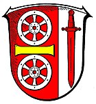
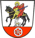
Until 1973, the Lorch coat of arms showed the coat of arms of Saint Martin with beggars in front of a silver background in the lower quarter, the Mainz wheel on a red background.
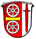
In 1973 it was replaced by a jointly designed coat of arms of the town of Lorchhausen and the town of Lorch in the course of the voluntary merger and approved on February 28, 1973 by the Hessian Minister of the Interior with the following blazon :
Shield split in a ratio of 2: 1: Two silver wheels on top of each other in red at the front, separated by a horizontal golden bar; behind in silver a red sword.
In the new coat of arms, the sword stands for the pierced St. Boniface Bible of the former Lorchhausen coat of arms, but also for the coat- dividing St. Martin from the old Lorch coat of arms. The Mainz wheel symbolizes the affiliation to the Electorate of Mainz, which has existed for centuries; the colors red and white represent the state of Hesse .
Town twinning
There are city partnerships with the following cities:
- Ligugé , France, since 1976
- Saint-Benoît , France, since 1976
Wine godfather town:
- Gütersloh , North Rhine-Westphalia
- Langenfeld (Rhineland) , North Rhine-Westphalia
Culture and sights
Museums
The Robert Struppmann Museum is the city's art and local history museum . It houses valuable carvings, documents, sculptures and sacred objects, including the carved wooden head of the beheaded John the Baptist from the 12th century and the enthroned Madonna with baby Jesus and grape from the early 14th century. The museum is open every weekend afternoon from 2 p.m. to 5 p.m. from Easter to the end of October. At the same time, it serves as an information center for tourists and offers free information brochures as well as books on Lorcher's history and local viticulture.
Buildings
- Parish Church of St. Martin : Over the remains of the partly preserved late Romanesque basilica in the 14th century, a Gothic Catholic church building with a Gothic high altar (1483) by Hans Bilger von Worms (attribution disputed); it is the largest surviving monochrome carved altar from the pre-Riemenschneider period, which is considered the most valuable work of art in the Limburg diocese.
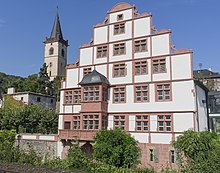
- The Hilchenhaus , residential house of the Rheingau family of the Hilchen von Lorch , from the mid-16th century, is known as the “most beautiful Renaissance building on the Middle Rhine”. Because of a failed hotel construction, in which the house was partially torn down, it was in ruins for a long time. Its repair was completed in early 2014.
- Nollig ruins , a remnant of the former city fortifications on a rocky ridge above the city.
- Strunk : An old fortification tower from 1527 that also served as a prison. Today there is a wedding room in it.
- Leper house with round tower: In this house, which was still outside the city in the Middle Ages, the lepers were cared for.
- Hexenturm : A prison in which from the Middle Ages to the 18th century, criminals and "witches" were kept.
- Kreuzkapelle : The chapel in the lower Wispertal was first mentioned in a document in 1486. As the last of the nine Lorch chapels, it is still preserved today. According to legend, it owes its creation to the vow of a knight from the Boos von Waldeck family . The chapel was consecrated on July 26, 1677 by Auxiliary Bishop Adolph Gottfried Volusius . After an extension in 1738, after a restoration in 1826, it was given its present shape. In 1897 a way of the cross was laid out, which was destroyed in 1971 and replaced in 1983 by a new design by the sculptor Anton Haust ( Presberg ).
Regular events
- Major event valley total annually on the last Sunday in June. The federal highway 42 on the right bank of the Rhine between Rüdesheim and Koblenz and the federal highway 9 on the left bank of the Rhine between Bingen and Koblenz are closed to traffic from 9 a.m. to 7 p.m. and are free for cyclists and skaters.
- Helchenfest annually on the third weekend in July
- Curb (parish fair / fair) annually the 2nd weekend in September.
- Lorcher Culture Days since 1991 annually at the end of September / beginning of October; Theater, concerts, exhibitions.
- Christmas market every Saturday before the first Advent.
- Rheingau Music Festival Concert in St. Martin, usually an organ concert in July, annually since 1988
- Tropical Tango in Wollmanders, on the first weekend in August.
Economy and Infrastructure
Economy and resident companies
Viticulture and tourism are important in Lorch. There are also numerous service and craft businesses. Due to the closure of the main medical depot in Lorch-Rheingau and the equipment depot, around 280 civilian jobs were lost. An industrial park was created on the former Bundeswehr site, which enabled numerous companies to settle there. The job losses have so far been partially offset by these measures. Larger local companies are Schwank Spedition GmbH and the packaging manufacturer Schlaadt Plastics GmbH.
In 2011 there were 736 jobs subject to social insurance in Lorch am Rhein.
traffic
Lorch is on the B 42 Koblenz –Wiesbaden and the largely parallel railway line. The distance to Wiesbaden to the motorway junction of the B 42 to the A 66 in the direction of Frankfurt is about 40 kilometers. There is a connection to the Mainz motorway junction - connection A 61 / A 60 Cologne / Koblenz / Ludwigshafen via the Wiesbaden-Schiersteiner Rheinbrücke and the Rhine ferries Lorch and Kaub at the Laudert and Rheinböllen driveways (approx. 15 km). The city is connected to the Rhein-Main-Verkehrsverbund via the right Rhine route . There is also the ORN bus line Wiesbaden-Lorchhausen. The Rheinsteig , the new long-distance hiking trail from Wiesbaden to Bonn via the Ehrenbreitstein fortress near Koblenz, leads over the Rheinhöhe from Lorch.
Viticulture
The viticulture in Lorch is within the wine area Rheingau under the Großlage Burgweg out. The individual layers are Kapellenberg (58 hectares), Schlossberg (53 hectares), Pfaffenwies (35 hectares), Bodental-Steinberg (23 hectares) and Krone (13 hectares).
The dominant grape variety is Riesling , but Pinot Noir also has an increasing share. Brandies and sparkling wine are also produced from the wines .
The vines grow on steep slopes , on stony, heat - storing slate and quartzite soils. The large water surface of the Rhine helps to equalize the temperature and at the same time acts as a reflector that directs the sunlight onto the vineyards and thus intensifies it.
Educational institution
- Wisper School (Primary School)
Hiking trails
- The Rheinsteig , the hiking trail on the right bank of the Rhine from Wiesbaden to Bonn, runs on the Rheinhöhe.
- The Rheingau Gebück hiking trail , established in 2000, has its end point in Lorch.
- The Wispertalsteig is a 15 km long premium circular route between the climatic health resort Espenschied (Lorch) and the Wisper .
Personalities
The noble families of the city called themselves "von Lorch". Its most important representative was Johann (III.) Hilchen von Lorch (1484–1548), knight and imperial field marshal .
sons and daughters of the town
- Johann Philipp Bohn (1597–1658), lawyer, chancellor and councilor
- Heinrich Wilhelm Dahlen (1853–1904), economist, publicist and general secretary of the German Winegrowing Association
- Hermann Klein (1904 – after 1964), President of the Mainz Federal Railway Directorate
- Hans Otto Jung (1920–2009), entrepreneur, jazz musician, patron
- Gerhard Schwenzer (* 1938), Catholic Bishop of Oslo from 1983 to 2005
- Arno Schilson (1945–2005), Catholic theologian
- Ivo Zell , winner of Jugend forscht and winner of the Gordon E. Moore Award at the Intel International Science and Engineering Fair 2017 with a flying wing aircraft
Other personalities associated with the city
- Friedrich von Stockheim (1462–1528), chief scholar of the city from 1505 to 1521
- Peter Paul Nahm (1901–1981), politician ( CDU ) and State Secretary
- Professor August Weckbecker (1888–1939), sculptor and painter
literature
- Robert Struppmann: Chronicle of the city of Lorch in the Rheingau. 1981, 1988
- Holger Simon : The high altar retable from Lorch am Rhein. Basic considerations on the modern concept of image . In: Norbert Nussbaum, Claudia Euskirchen, Stephan Hoppe (eds.): Paths to the Renaissance. Observations on the beginnings of modern art perception in the Rhineland and neighboring areas around 1500 . Cologne 2003. pp. 364-389.
Individual evidence
- ↑ Hessian State Statistical Office: Population status on December 31, 2019 (districts and urban districts as well as municipalities, population figures based on the 2011 census) ( help ).
- ↑ Topographic map 1: 25,000
- ^ "Lorch, Rheingau-Taunus-Kreis". Historical local lexicon for Hessen (as of March 31, 2014). In: Landesgeschichtliches Informationssystem Hessen (LAGIS). Hessian State Office for Historical Cultural Studies (HLGL), accessed on November 2, 2014 .
- ^ "Lorch, forced labor camp in the Zehnthof of the Hilchenhaus". Topography of National Socialism in Hesse. In: Landesgeschichtliches Informationssystem Hessen (LAGIS).
- ^ Federal Statistical Office (ed.): Historical municipality directory for the Federal Republic of Germany. Name, border and key number changes in municipalities, counties and administrative districts from May 27, 1970 to December 31, 1982 . W. Kohlhammer GmbH, Stuttgart and Mainz 1983, ISBN 3-17-003263-1 , p. 375 .
- ↑ Law on the reorganization of the Rheingau district and the Untertaunus district (GVBl. II 330-30) of June 26, 1974 . In: The Hessian Minister of the Interior (ed.): Law and Ordinance Gazette for the State of Hesse . 1974 No. 22 , p. 312 , § 12 ( online at the information system of the Hessian state parliament [PDF; 1.5 MB ]).
- ^ Result of the municipal election on March 6, 2016. Hessian State Statistical Office, accessed in April 2016 .
- ^ Hessian State Statistical Office: Result of the municipal elections on March 27, 2011
- ^ Hessian State Statistical Office: Result of the municipal elections on March 26, 2006
- ^ Direct elections in Lorch, city. Hessian State Statistical Office , accessed in January 2020 .
- ^ Yearbook 2020 of the Rheingau-Taunus-Kreis, page 222: Lorch. Ivo Reßler creates the sensation. The mayoral election wins more independently / daycare centers remain in the discussion.
- ↑ Approval of a coat of arms of the city of Lorch, Rheingaukreis from February 28, 1973 . In: The Hessian Minister of the Interior (ed.): State Gazette for the State of Hesse. 1973 No. 12 , p. 541 , point 401 ( online at the information system of the Hessian state parliament [PDF; 4.1 MB ]).
- ^ City of Lorch about the parish church of St. Martin
- ↑ Legend of the Lorch Kreuzkapelle (PDF file; 17 kB)
- ^ Pastor Albert Zell: The history of the parish of St. Martin Lorch am Rhein 1806–1906. P. 67. Excerpt from the chronicle of the Lorcher honor guard
- ^ Sights in Lorch
- ↑ Location information Lorch
- ↑ Hessenschau.de, accessed on May 24, 2017
Documents
- Picture by Lorch from JF Dielmann, A. Fay, J. Becker (draftsman): FC Vogel's panorama of the Rhine, pictures of the right and left banks of the Rhine, FC Vogel lithographic institution, Frankfurt 1833
- Image of the Nollingen ruins from JF Dielmann, A. Fay, J. Becker (draftsman): FC Vogel's Panorama of the Rhine, images of the right and left banks of the Rhine, FC Vogel lithographic institute, Frankfurt 1833
- Image by Lorchhausen from JF Dielmann, A. Fay, J. Becker (draftsman): FC Vogel's panorama of the Rhine, images of the right and left banks of the Rhine, FC Vogel lithographic institution, Frankfurt 1833
Web links
- List of cultural monuments in Lorch (Rheingau)
- Official website of the city of Lorch
- "Lorch, Rheingau-Taunus-Kreis". Historical local dictionary for Hessen. In: Landesgeschichtliches Informationssystem Hessen (LAGIS).
- Literature about Lorch in the Hessian Bibliography
- List of former Bundeswehr properties
- Link catalog on Lorch at curlie.org (formerly DMOZ )
- Literature on Lorch in the catalog of the German National Library


