
Zziwil
| Zziwil | |
|---|---|
 |
|
| State : |
|
| Canton : |
|
| Administrative district : | Bern-Mittelland |
| BFS no. : | 0628 |
| Postal code : | 3532 |
| UN / LOCODE : | CH ZAZ |
| Coordinates : | 616994 / 194 561 |
| Height : | 686 m above sea level M. |
| Height range : | 666–962 m above sea level M. |
| Area : | 5.41 km² |
| Residents: | 1595 (December 31, 2018) |
| Population density : | 295 inhabitants per km² |
| Website: | www.zaeziwil.ch |
 Zziwil |
|
| Location of the municipality | |
  |
|

Zäziwil ( Bern German Zäziwiu [ t͡sæt͡siviːu ]) is a municipality in the Bern-Mittelland of Canton Bern in Switzerland .
geography
Gäziwil lies at 686 m above sea level. M. , 4 km northeast of Konolfingen and 17 km east-southeast of the city of Bern (linear distance). The village is located in the wide valley floor of Chise between the heights of Blasenflue in the north and the short hill to the south, both sides of which opens here in the Chise Zäzibachs .
The area of the 5.4 km² large municipal area comprises a section of the relatively heavily reliefed hill country between the Aare valley and the Emmental . The central part is taken up by the wide upper Chisetal, which with its valley watershed ensures an easy transition from the Aare valley to the Emmental. The valley basin in the area of zziwil is around 1 km wide, but is narrowed east of the village by the bar of the Bärwilhubel ( 724 m above sea level ). To the north, the municipality bottom extends into the lower portion of the Zäzibachtals and the steep slope of the Buelenbergwaldes to the Spitzchnubel (Blasenfluemassivs of the streamer), on which with 963 m above sea level. M. the highest point of zziwil is reached.
South of the valley basin, the municipal ban extends over the Bärbach valley and the clearing island of Reutenen to the heights of Hüttewald ( 923 m above sea level ), Leenhubel ( 909 m above sea level ) and Schafegg ( 932 m above sea level ) belonging to the Kurzenberg . ). In 1997, 10% of the municipal area was accounted for by settlements, 26% for forests and woodlands and 64% for agriculture.
The hamlets of Leimen ( 712 m above sea level ) and Länzligen ( 740 m above sea level ) on the western edge of the village, Reutenen ( 838 m above sea level ) and Oberreutenen ( 880 m above sea level ) in a cleared island belong to zziwil on the northern roof of the Kurzenberg as well as various courtyard groups and individual courtyards. Neighboring communities tozaziwil are Oberthal , Bowil , Oberhünigen , Mirchel and Grosshöchstetten .
history
Thezaziwil settlement was probably founded by the Alemanni between 700 and 900 AD . The place was first mentioned in a document in 1299 under the name Cezzenwile . Later the names Zetzenwile (1320), Zatzenwile (1330), Zezenwilen (1356), Zetzenwil (1389) and Zatzenwyl (1681) appeared. The place name possibly originated from the agglutination of the preposition to an Old High German personal name in the form Az (z) o or Ez (z) o . The names Zaz (z) o or Zez (z) o are also possible interpretations. The name therefore means at the homestead of the Azo (or one of the other name variants).
In the Middle Ages , zziwil belonged to the Signau lordship, which was under the sovereignty of the Counts of Kyburg . Together with Signau, the village came to the city of Bern in 1399, but was sold on to the Bernburger von Büren. After zziwil came under the direct rule of the city of Bern in 1529, it was assigned to the newly created Landvogtei Signau; The place of jurisdiction was Konolfingen. After the collapse of the Ancien Régime (1798), Gäziwil belonged to the Höchstetten district during the Helvetic Republic and from 1803 to the Konolfingen Oberamt, which received the status of an official district with the new cantonal constitution of 1831.
population
With 1595 inhabitants (as of December 31, 2018) zziwil is one of the medium-sized communities in the canton of Bern. 96.8% of the residents speak German, 1.1% speak Italian and 0.6% speak Turkish (as of 2000). The population of zziwil was 1042 inhabitants in 1850 and 1228 inhabitants in 1900. In the course of the 20th century, the population initially fluctuated between 1150 and 1300 people. Since 1980 (1144 inhabitants) there has been a significant increase in population.
politics
The voting shares of the parties at the 2015 National Council elections were: SVP 40.2%, BDP 16.9%, SP 14.6%, GPS 6.0%, FDP 6.0%, EPP 5.1%, glp 4.7 %, EDU 3.3%.
economy
To the second half of the 20th century ,zaziwil was a village dominated by agriculture . Agriculture , dairy farming and cattle breeding still play an important role in the income structure of the population today . Numerous other jobs are available in local small businesses and in the service sector. Construction, mechanical engineering, plastics, electrical, mechanical workshops and carpenters are all represented in zziwil. There is an indoor climbing facility in the village. In the past few decades, zziwil has developed into a residential community. Many employees are therefore commuters who work mainly in the larger towns in the area and in the agglomeration of Bern.
traffic
The community is very well developed in terms of traffic. It is located on the main road that leads from Bern via Langnau in the Emmental to Lucerne . On June 1, 1864, the Gümligen –Langnau section in the Emmental of the Bern – Lucerne railway line was opened with a train station in Gäziwil. A PostBus course , which covers the route from Grosshöchstetten via Gäziwil to Oberthal, ensures the fine distribution in public transport .
regional customs
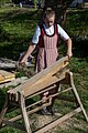
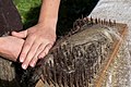
Every year on the last Wednesday in September, the Brächete festival has been held since 1954 . Here, the interested public is shown flax processing as it was carried out during the 19th century.
Attractions
The Reformed Church of zziwil was built in 1964. It is also worth mentioning the Gasthof Krone, a cross-ridge structure with three rounded fronts from around 1800. In the old town center, various stately farmhouses in the Bernese style from the 18th and 19th centuries have been preserved.
photos

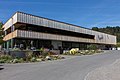
railway station
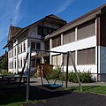
school
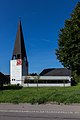
reformed Church
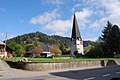
reformed Church

Farmhouse
Chäsi Eyweid

Brächete: fluted linen
Brächete: Break lines

Brächete: lines swing
Brächete: panting lines


Web links
- Official website of the municipality of zziwil
- Anne-Marie Dubler : zziwil. In: Historical Lexicon of Switzerland .
Individual evidence
- ↑ Permanent resident population from STAT-TAB of the BfS , municipalities see also regional portraits 2020 on bfs.admin.ch, accessed on May 29, 2020
- ↑ Elections 2015: Results of the commune zziwil. Canton of Bern, accessed on March 21, 2016
Allmendingen | Arni | Bäriswil | Belp | Bern | Biglen | Bolligen | Bowil | Bremgarten near Bern | Brenzikofen | Clavaleyres | Deisswil near Münchenbuchsee | Diemerswil | Ferenbalm | Fraubrunnen | Frauenkappelen | Open-leaved | Gerzensee | Grosshöchstetten | Guggisberg | Gurbrü | Membranous | Herbigen | Iffwil | Ittigen | Jaberg | Jegenstorf | Kaufdorf | Sweep | Gravel | Kirchdorf | Kirchlindach | Köniz | Konolfingen | Kriechenwil | Landiswil | Laupen | Linden | Mattstetten | Meikirch | Mirchel | Moosseedorf | Mühleberg | Münchenbuchsee | Münchenwiler | Münsingen | Muri near Bern | Neuenegg | Niederhünigen | Niedermuhlern | Oberbalm | Oberdiessbach | Oberhünigen | Oberthal | Oppligen | Ostermundigen | Riggisberg | Rubigen | Rüeggisberg | Rümligen | Rüschegg | Schwarzenburg | Stettlen | Thurnen | Toff | Urtenen-Schönbühl | Vechigen | Forest | Walk rings | Wichtrach | Wiggiswil | Wileroltigen | Wohlen near Bern | Worb | Zziwil | Zollikofen | Zuzwil
Former communities: Aeschlen bei Oberdiessbach | Albligen | Ausserbirrmoos | Ball moss | Perch wall | Belpberg | Bleiken near Oberdiessbach | Bremgarten City Court | Bümpliz | Büren to the yard | Englisberg | Etzelkofen | Gelterfingen | Golats | Grafenried | Gysenstein | Hoods | Innerbirrmoos | Church gymnastics | Limpach | Lohnstorf | Mädersforst | Measure barns | Mühledorf | Mill urns | Mülchi | Münchringen | Niederwichtrach | Noflen | Oberscheunen | Oberwichtrach | Otterbach near Oberdiessbach | Rüti near Riggisberg | Shells | Barns | Schlosswil | Schönthal | Stalden in the Emmental | Tägertschi | Trimstone | Electors | Zauggenried | Zimmerwald
Canton of Bern | Administrative districts of the canton of Bern | Municipalities of the Canton of Bern