Sány
| Sány | ||||
|---|---|---|---|---|
|
||||
| Basic data | ||||
| State : |
|
|||
| Region : | Středočeský kraj | |||
| District : | Nymburk | |||
| Area : | 948 ha | |||
| Geographic location : | 50 ° 7 ' N , 15 ° 15' E | |||
| Height: | 196 m nm | |||
| Residents : | 523 (Jan. 1, 2019) | |||
| Postal code : | 289 06 | |||
| License plate : | S. | |||
| traffic | ||||
| Street: | Opolany - Polní Chrčice | |||
| Railway connection: | Velký Osek – Trutnov | |||
| structure | ||||
| Status: | local community | |||
| Districts: | 1 | |||
| administration | ||||
| Mayor : | Marie Žďárská (as of 2019) | |||
| Address: | 9. května 16 289 06 Sány |
|||
| Municipality number: | 537772 | |||
| Website : | www.obecsany.cz | |||
Sány (German Saan ) is a municipality in the Czech Republic. It is located nine kilometers east of Poděbrady and belongs to the Okres Nymburk .
geography
Sány is on the left side of the Cidlina at the outflow of the Sánská Bačovka on the East Bohemian Table. The Kozí hůra (272 m) rises to the east. In the north-west runs the railway line Velký Osek – Trutnov , which crosses the Cidlina here. The railway station of the same name "Sány" is located in the corridors of Opolánky. To the south, the village is bypassed by the D 11 / European route 67 , the next exit 50 "Žehuň" is two kilometers east of the village.
Neighboring towns are Opolánky and Badra in the north, Libněves and Dobšice in the northeast, Hájky and Polní Chrčice in the southeast, Jestřabí Lhota and Volárna in the south, Velký Osek in the southwest, Kanín in the west and Opolany in the northwest.
history
Sány and the church were first mentioned in documents in 1352, when the Cistercian monastery of Hradiště was confirmed to own the village together with Žehuň , Badra and the old, now extinct, settlement of Oškobrh near Vlkov pod Oškobrhem . Also in the 14th century, the Vladiken von Dolany built a fortress. In addition, there was another Vladikensitz in Sány with the Freihof since the 15th century. a. the Hussite leader Jan Čapek ze Sán .
After the Battle of Lipan , the general Bedřich von Strážnice acquired most of Sány together with Kolín . Only the Freihof from then on belonged to other owners and then passed to Georg von Podiebrad . Podiebrad, who had also bought the Kolín estate from Bedřich von Strážnice in 1458, had the Cidlina from Sánský kanál built north of the village , which fed the large Bláto fish pond. In 1475 the ditch Sánská Bačovka, which supplied water from the Cidlina to the new Bačovský rybník pond . Several mills were built along the canals. The population of Sány has been utraquist since the Hussite period, and from 1620 the re-Catholicisation began. The parish expired during this time and the church became a branch of the Alt-Kolin parish until 1787 . In 1638 the first village school was established. As a result of the tolerance patent , a Protestant parish was formed in Sány at the end of the 18th century, which was parish to Libice nad Cidlinou due to the small number of members .
In 1843 the rustic village Saan or Sán , also called Sány , in the Kauřim district consisted of 60 houses in which 442 people, including 18 Protestant and one Jewish family, lived. The main source of income was agriculture; Above all, clover was grown in the fields for seed production. The local church of St. Apostle Andrew, the locality and the school. There was also a stately forester's house, a mill on the Cidlina and two inns in the village. Saan was the Catholic parish for Freudenek and Unter-Opolan ; the place of office was Kaisersdorf . Until the middle of the 19th century Saan remained subject to the Kolín rule.
After the abolition of patrimonial, Sány formed a community in the judicial district of Königstadtl from 1850 . 1862 acquired Franz Horsky the manorial Kolin from the heirs of Baron Wenceslas Veith. Horsky immediately initiated a modernization of agriculture and founded the Hajka farm as a model agricultural estate. From 1868 the village belonged to the Poděbrad district . In 1870 the railway from Groß Wossek to Wostromer started operating . On January 1, 1961, the community came to Okres Nymburk.
Community structure
No districts are shown for the municipality of Sány. Sány includes the single-layer Hájky ( Hajka ).
Attractions
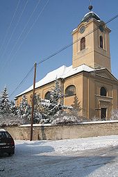
- Parish church of St. Andreas, built 1824–1825 in Empire style instead of a smaller previous building from the 13th century. In 1856 the chaplain, which had existed since 1787, was elevated to a parish.
Personalities
- Jan Čapek ze Sán (around 1427 - after 1445), Hussite leader
Web links
Individual evidence
- ↑ http://www.uir.cz/obec/537772/Sany
- ↑ Český statistický úřad - The population of the Czech municipalities as of January 1, 2019 (PDF; 7.4 MiB)
- ^ Johann Gottfried Sommer : The Kingdom of Bohemia, Vol. 12 Kauřimer Kreis, 1844 p. 232


