Arreux
| Arreux | ||
|---|---|---|

|
|
|
| region | Grand Est | |
| Department | Ardennes | |
| Arrondissement | Charleville-Mezieres | |
| Canton | Charleville-Mézières-2 | |
| Community association | Ardenne metropolis | |
| Coordinates | 49 ° 50 ′ N , 4 ° 39 ′ E | |
| surface | 4.23 km 2 | |
| Residents | 324 (January 1, 2017) | |
| Population density | 77 inhabitants / km 2 | |
| Post Code | 08090 | |
| INSEE code | 08022 | |
| Website | http://www.arreux.fr/ | |
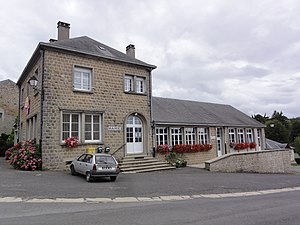
 Arreux Town Hall |
||
Arreux is a French commune with 324 inhabitants (as of January 1, 2017) in the Ardennes department in the Grand Est region (before 2016 Champagne-Ardenne ). It belongs to the arrondissement Charleville-Mézières , the canton Charleville-Mézières-2 (until 2015 Renwez ) and the municipality association Ardenne Métropole .
geography
The village of Arreux is located in a hilly area on the edge of the Ardennes in the Ardennes Regional Nature Park, founded in 2011 . Arreux is surrounded by the neighboring communities of Damouzy in the east, Houldizy in the south, by the communities of Tournes and Cliron in the canton of Charleville-Mézières-1 in the southwest and by the municipality of Montcornet in the canton of Bogny-sur-Meuse in the west, north and northeast.
Population development
| year | 1962 | 1968 | 1975 | 1982 | 1990 | 1999 | 2007 | 2015 |
|---|---|---|---|---|---|---|---|---|
| Residents | 205 | 199 | 195 | 256 | 297 | 320 | 363 | 332 |
| Source: Cassini and INSEE | ||||||||
Attractions
- Château d'Arreux (private property)
The building was erected in 1756 as a farmhouse for the governor of Mézières. In the park is one of the few orangeries in the French Ardennes from the early 19th century.
- Saint-Lambert Church

