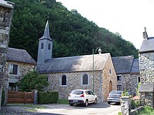
Landrichamps
| Landrichamps | ||
|---|---|---|
|
|
||
| region | Grand Est | |
| Department | Ardennes | |
| Arrondissement | Charleville-Mezieres | |
| Canton | Givet | |
| Community association | Ardenne, Rives de Meuse | |
| Coordinates | 50 ° 5 ′ N , 4 ° 50 ′ E | |
| height | 135-342 m | |
| surface | 4.72 km 2 | |
| Residents | 131 (January 1, 2017) | |
| Population density | 28 inhabitants / km 2 | |
| Post Code | 08600 | |
| INSEE code | 08247 | |
| Website | http://landrichamps.fr/ | |
 Landrichamps Town Hall (Mairie) |
||
Landrichamps is a French commune with 131 inhabitants (as of January 1, 2017) in the Ardennes department in the Grand Est region (until 2015 Champagne-Ardenne ). It belongs to the arrondissement Charleville-Mézières , the canton Givet and the municipality association Ardenne, Rives de Meuse .
geography
The community is on the border with Belgium , two kilometers east of the Chooz nuclear power plant . Landrichamps is surrounded by the neighboring communities of Chooz in the west, Charnois in the north and northeast and the Belgian municipality of Beauraing in the southeast and south.
Population development
| year | 1962 | 1968 | 1975 | 1982 | 1990 | 1999 | 2007 | 2015 |
|---|---|---|---|---|---|---|---|---|
| Residents | 155 | 147 | 127 | 166 | 139 | 132 | 142 | 134 |
| Source: Cassini and INSEE | ||||||||
Attractions
- Sainte-Maguerite Church
Web links
Commons : Landrichamps - collection of images, videos and audio files

