
Blanchefosse-et-Bay
| Blanchefosse-et-Bay | ||
|---|---|---|

|
|
|
| region | Grand Est | |
| Department | Ardennes | |
| Arrondissement | Charleville-Mezieres | |
| Canton | Signy-l'Abbaye | |
| Community association | Ardennes Thiérache | |
| Coordinates | 49 ° 47 ' N , 4 ° 14' E | |
| height | 170-278 m | |
| surface | 20.47 km 2 | |
| Residents | 151 (January 1, 2017) | |
| Population density | 7 inhabitants / km 2 | |
| Post Code | 08290 | |
| INSEE code | 08069 | |

Blanchefosse-et-Bay is a French commune with 151 inhabitants (as of January 1, 2017) in the Ardennes department in the Grand Est region (before 2016: Champagne-Ardenne ). It belongs to the arrondissement Charleville-Mézières , the canton Signy-l'Abbaye (until 2015: Rumigny ) and the municipality association Ardennes Thiérache .
geography
Blanchefosse-et-Bay is located in the Ardennes Regional Nature Park, founded in 2011 . Blanchefosse-et-Bay is surrounded by the neighboring communities of Rumigny in the north, Aouste in the northeast, west, La Férée in the east, Le Fréty in the south, Résigny in the southwest, Les Autels and Brunehamel in the west and Mont-Saint-Jean in the Aisne department in Northwest.
history
On January 1, 1974, the previously independent municipalities of Bay and Blanchefosse were merged to form today's municipality.
Population development
| year | 1962 | 1968 | 1975 | 1982 | 1990 | 1999 | 2006 | 2013 | 2016 |
| Residents | 220 | 210 | 261 | 210 | 184 | 152 | 153 | 159 | 156 |
| Source: Cassini and INSEE | |||||||||
Attractions
- Ruins of the Bonnefontaine Monastery of Blanchefosse, MH (1926)
- Church (Église Saint-Jean-Baptiste) of Blanchefosse
- Bay Church

Monastery ruin
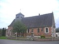
Blanchefosse Church
_-_l%E2%80%99Abbaye_de_Bonne_Fontaine_-_Photo_Francis_Neuvens.JPG)
