
L'Échelle
| L'Échelle | ||
|---|---|---|

|
|
|
| region | Grand Est | |
| Department | Ardennes | |
| Arrondissement | Charleville-Mezieres | |
| Canton | Signy-l'Abbaye | |
| Community association | Ardennes Thiérache | |
| Coordinates | 49 ° 48 ′ N , 4 ° 28 ′ E | |
| height | 174-299 m | |
| surface | 9.96 km 2 | |
| Residents | 137 (January 1, 2017) | |
| Population density | 14 inhabitants / km 2 | |
| Post Code | 08150 | |
| INSEE code | 08149 | |
 Town hall (Mairie) by L'Échelle |
||

L'Échelle is a French commune with 137 inhabitants (as of January 1, 2017) in the Ardennes department in the Grand Est region (before 2016: Champagne-Ardenne ). It belongs to the arrondissement Charleville-Mézières , the canton Signy-l'Abbaye (until 2015: canton Rumigny ) and the municipality association Ardennes Thiérache . The inhabitants are called Echellois .
L'Échelle is surrounded by the neighboring communities Laval-Morency in the north, Le Châtelet-sur-Sormonne in the northeast, Rouvroy-sur-Audry in the south, Vaux-Villaine in the southwest and Blombay in the west.
Population development
| year | 1962 | 1968 | 1975 | 1982 | 1990 | 1999 | 2006 | 2011 | 2016 |
| Residents | 182 | 204 | 193 | 198 | 184 | 146 | 137 | 133 | 134 |
| Source: Cassini and INSEE | |||||||||
Attractions
- Saint-Pierre church
- Castle, MH since 1926 , with school museum
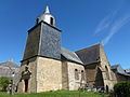
Saint-Pierre church
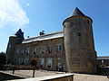
lock
_%C3%A9glise,_vue_lat%C3%A9rale.JPG)
_ch%C3%A2teau_(mairie_et_mus%C3%A9e).JPG)
Web links
Commons : L'Échelle - collection of images, videos and audio files