Aouste
| Aouste | ||
|---|---|---|

|
|
|
| region | Grand Est | |
| Department | Ardennes | |
| Arrondissement | Charleville-Mezieres | |
| Canton | Signy-l'Abbaye | |
| Community association | Ardennes Thiérache | |
| Coordinates | 49 ° 48 ′ N , 4 ° 19 ′ E | |
| height | 187-289 m | |
| surface | 12.83 km 2 | |
| Residents | 207 (January 1, 2017) | |
| Population density | 16 inhabitants / km 2 | |
| Post Code | 08290 | |
| INSEE code | 08016 | |
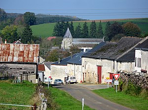
 South entrance to Aouste |
||
Aouste is a French commune with 207 inhabitants (as of January 1, 2017) in the Ardennes department in the Grand Est region (before 2016 Champagne-Ardenne ). It belongs to the arrondissement Charleville-Mézières , the canton Signy-l'Abbaye (until 2015 Rumigny ) and the municipality association Ardennes Thiérache .
geography
Aouste is surrounded by the neighboring communities Rumigny in the west, Champlin in the northwest, Estrebay in the north, Prez in the east, Liart in the southwest, La Férée in the south and Blanchefosse-et-Bay in the southwest. The municipality is crossed by the river Aube , a tributary of the Ton .
Population development
| year | 1962 | 1968 | 1975 | 1982 | 1990 | 1999 | 2007 | 2016 | |
| Residents | 332 | 292 | 264 | 268 | 203 | 208 | 203 | 209 | |
| Source: Cassini and INSEE | |||||||||
Origin of name
The place was first attested as Augusta in 887 .
Attractions
- Saint-Rémi fortified church , built in the 17th century, monument historique since 1922
Web links
Commons : Aouste - collection of images, videos and audio files
Individual evidence
- ^ Ernest Nègre, Toponymie générale de la France , page 618.
- ↑ Entry no. PA00078332 in the Base Mérimée of the French Ministry of Culture (French)

