
Auvillers-les-Forges
| Auvillers-les-Forges | ||
|---|---|---|

|
|
|
| region | Grand Est | |
| Department | Ardennes | |
| Arrondissement | Charleville-Mezieres | |
| Canton | Rocroi | |
| Community association | Ardennes Thiérache | |
| Coordinates | 49 ° 52 ' N , 4 ° 22' E | |
| height | 235-296 m | |
| surface | 8.19 km 2 | |
| Residents | 877 (January 1, 2017) | |
| Population density | 107 inhabitants / km 2 | |
| Post Code | 08260 | |
| INSEE code | 08037 | |
_Mairie.JPG) Town hall (Mairie) of Auvillers-les-Forges |
||

Auvillers-les-Forges is a French commune with 877 inhabitants (as of January 1, 2017) in the Ardennes department in the Grand Est region (until 2015 Champagne-Ardenne ). It belongs to the arrondissement Charleville-Mézières , the canton Rocroi (until 2015: canton Signy-le-Petit ) and the municipality association Ardennes Thiérache .
geography
Auvillers-les-Forges is located in the Ardennes Regional Nature Park, which was founded in 2011 . Auvillers-les-Forges is surrounded by the neighboring communities of Neuville-lez-Beaulieu in the north and west, Éteignières in the north-east, Girondelles in the east and south-east, Champlin in the south and south-west and Antheny in the south-west.
Population development
| year | 1962 | 1968 | 1975 | 1982 | 1990 | 1999 | 2006 | 2011 | 2016 |
| Residents | 803 | 811 | 784 | 799 | 822 | 833 | 885 | 890 | 875 |
| Source: Cassini and INSEE | |||||||||
Attractions
- Saint-Nicolas church
- Market hall , built in 1852
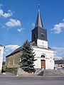
Saint-Nicolas church

Market hall
_%C3%89glise.JPG)

Web links
Commons : Auvillers-les-Forges - Collection of images, videos and audio files