
Ham-sur-Meuse
| Ham-sur-Meuse | ||
|---|---|---|
|
||
| region | Grand Est | |
| Department | Ardennes | |
| Arrondissement | Charleville-Mezieres | |
| Canton | Givet | |
| Community association | Ardenne, Rives de Meuse | |
| Coordinates | 50 ° 7 ' N , 4 ° 47' E | |
| height | 102-348 m | |
| surface | 6.19 km 2 | |
| Residents | 238 (January 1, 2017) | |
| Population density | 38 inhabitants / km 2 | |
| Post Code | 08600 | |
| INSEE code | 08207 | |

Ham-sur-Meuse is a French commune with 238 inhabitants (as of January 1, 2017) in the Ardennes department in the Grand Est region (until 2015 Champagne-Ardenne ). It belongs to the arrondissement Charleville-Mézières and the municipality association Ardenne, Rives de Meuse .
geography

Ham-sur-Meuse is located on the Meuse (French: Meuse ) in the Ardennes , 45 kilometers north of the departmental capital Charleville-Mézières and about 50 kilometers south of Namur . The Meuse describes a 180 ° loop in Ham-sur-Meuse , on the inside of which the village of Ham was built to be flood-proof on a sliding slope . The Canal de la Meuse , which runs parallel to the Meuse, branches off at Ham-sur-Meuse into a canal tunnel that shortens another 180 ° Maass loop. The municipality includes the river islands Islon Judas and Île Gistrois and a tubular mountain forest area extending five kilometers to the south. In the immediate vicinity is the Chooz nuclear power plant , which can be seen from every point in the village of Ham. The neighboring communities are Foisches in the north, Chooz in the east, Hargnies in the south and Aubrives in the west. The 6.19 km² municipal area of Ham-sur-Meuse is part of the Ardennes Regional Nature Park .
Population development
| year | 1962 | 1968 | 1975 | 1982 | 1990 | 1999 | 2006 | 2015 |
|---|---|---|---|---|---|---|---|---|
| Residents | 225 | 193 | 187 | 202 | 229 | 246 | 244 | 243 |
| Source: Cassini and INSEE | ||||||||
Attractions
- Saint-Nicaise church
- Saint-Nicolas chapel
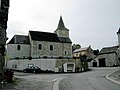
Saint-Nicaise church
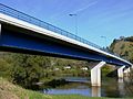
Meuse bridge in Ham

Lock number 57 of the Canal de la Meuse


supporting documents
- ↑ Han-sur-Meuse on cassini.ehess.fr (French)