
Lumes
| Lumes | ||
|---|---|---|

|
|
|
| region | Grand Est | |
| Department | Ardennes | |
| Arrondissement | Charleville-Mezieres | |
| Canton | Villers-Semeuse | |
| Community association | Ardenne metropolis | |
| Coordinates | 49 ° 44 ' N , 4 ° 47' E | |
| height | 143-252 m | |
| surface | 6.14 km 2 | |
| Residents | 1,142 (January 1, 2017) | |
| Population density | 186 inhabitants / km 2 | |
| Post Code | 08440 | |
| INSEE code | 08263 | |
| Website | www.lumes.fr | |
 Town Hall ( Mairie ) of Lumes |
||

Lumes is a French commune with 1,142 inhabitants (as of January 1, 2017) in the Ardennes department in the Grand Est region . It belongs to the arrondissement Charleville-Mézières and is part of the canton of Villers-Semeuse . The inhabitants are called Lumichons .
geography
Lumes is located about three kilometers southeast of the city center of Charleville-Mézières on the Meuse (French: Meuse ). Lumes is surrounded by the neighboring communities of Ville-sur-Lumes in the north, Vivier-au-Court in the east, Nouvion-sur-Meuse in the south, Chalandry-Elaire in the south-west, Les Ayvelles in the west and south-west, Villers-Semeuse in the west and Saint -Laurent to the northwest.
The A34 autoroute and the Mohon – Thionville railway line run through the community .
Population development
| year | 1962 | 1968 | 1975 | 1982 | 1990 | 1999 | 2006 | 2013 |
|---|---|---|---|---|---|---|---|---|
| Residents | 966 | 951 | 963 | 1,116 | 1,251 | 1,224 | 1,144 | 1,172 |
| Source: Cassini and INSEE | ||||||||
Attractions
- Saint-Brice church
- Remains of the Lumes Castle from the 14th century, a historic monument since 1994

Saint-Brice church
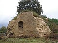
Lumes castle ruins

