
Warnécourt
| Warnécourt | ||
|---|---|---|
|
||
| region | Grand Est | |
| Department | Ardennes | |
| Arrondissement | Charleville-Mezieres | |
| Canton | Nouvion-sur-Meuse | |
| Community association | Crêtes Préardennaises | |
| Coordinates | 49 ° 44 ' N , 4 ° 39' E | |
| height | 154-269 m | |
| surface | 5.36 km 2 | |
| Residents | 372 (January 1, 2017) | |
| Population density | 69 inhabitants / km 2 | |
| Post Code | 08090 | |
| INSEE code | 08498 | |
_mairie.JPG) Mairie Warnécourt since September 2000 |
||

Warnécourt is a French commune with 372 inhabitants (as of January 1, 2017) in the Ardennes department in the Grand Est region (until 2015 Champagne-Ardenne ). It belongs to the Arrondissement Charleville-Mézières and the community association Crêtes Préardennaises founded in 1995 .
geography
Warnécourt is located on the southern foothills of the Ardennes , five kilometers southwest of the Département capital Charleville-Mézières . The partly forested hilly terrain with the highest point at 269 m above sea level slopes north to the wide valley of the Meuse . The districts of Le Moulin and Le Champ-Donnet belong to the municipality . Warnécourt is surrounded by the neighboring communities of Warcq in the north, Prix-lès-Mézières in the northeast, Évigny in the east, Mondigny in the south and Fagnon in the west.
Population development
| year | 1962 | 1968 | 1975 | 1982 | 1990 | 1999 | 2006 | 2016 |
| Residents | 139 | 136 | 168 | 324 | 373 | 387 | 372 | 366 |
| Sources: Cassini and INSEE | ||||||||
Attractions
- Saint-Martin church, built on the site of a previous chapel from the 16th century
- Warnécourt Castle from the 16th century
- Lavoir
- Fallen memorial

Saint Martin Church

Warnécourt Castle
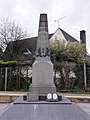
Fallen memorial
_%C3%A9glise_(2).JPG)
_ch%C3%A2teau.JPG)
_monument_aux_morts.JPG)
Economy and Infrastructure
Agriculture only plays a minor role in Warnécourt. Since the end of the 20th century, the community has become a preferred place of residence for families from the nearby city of Charleville-Mézières . Many residents are therefore commuters. The D3 road runs through the commune from Charleville-Mézières to Launois-sur-Vence . The RN 51 , a motorway-like structure, runs along the northern municipal boundary and is to lead from Reims via Rocroi on the Belgian border to Charleroi in Belgium .