
Gruyères (Ardennes)
| Gruyères | ||
|---|---|---|

|
|
|
| region | Grand Est | |
| Department | Ardennes | |
| Arrondissement | Charleville-Mezieres | |
| Canton | Signy-l'Abbaye | |
| Community association | Crêtes Préardennaises | |
| Coordinates | 49 ° 43 ' N , 4 ° 36' E | |
| height | 211-306 m | |
| surface | 5.48 km 2 | |
| Residents | 99 (January 1, 2017) | |
| Population density | 18 inhabitants / km 2 | |
| Post Code | 08430 | |
| INSEE code | 08201 | |
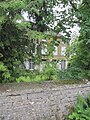
 Château de Gruyeres |
||

Gruyères is a French commune with 99 inhabitants (as of January 1, 2017) in the Ardennes department in the Grand Est region (before 2016 Champagne-Ardenne ). It belongs to the arrondissement Charleville-Mézières , the canton Signy-l'Abbaye and the municipal association Crêtes Préardennaises .
geography
The municipality lies in a geological transition zone between the Ardennes massif and the calcareous plains of Champagne. Gruyères is surrounded by the neighboring communities of Barbaise and Jandun in the southwest, by the municipality of Fagnon, which belongs to the canton of Charleville-Mézières-1, in the west and north, and by the municipalities of Mondigny in the canton of Nouvion-sur-Meuse in the east and Guignicourt-sur-Vence and Touligny in the south.
history
A Roman presence is proven by traces of military camps. The Roman road Reims - Pagus Castricius - Cologne led along the forests of Gruyères.
Population development
| year | 1962 | 1968 | 1975 | 1982 | 1990 | 1999 | 2004 | 2009 | 2016 |
| Residents | 40 | 34 | 44 | 49 | 52 | 51 | 62 | 68 | 99 |
| Source: Cassini and INSEE | |||||||||
Attractions
- Roman road
- Château de Gruyères, Monument historique since 2010

Entrance area of the château
West facade of the château


Web links
Individual evidence
- ↑ Roman ways in the Ardennes (French)
- ↑ Entry no. PA08000012 in the Base Mérimée of the French Ministry of Culture (French)