Revin
| Revin | ||
|---|---|---|

|
|
|
| region | Grand Est | |
| Department | Ardennes | |
| Arrondissement | Charleville-Mezieres | |
| Canton | Revin | |
| Community association | Ardenne, Rives de Meuse | |
| Coordinates | 49 ° 57 ' N , 4 ° 38' E | |
| height | 117-469 m | |
| surface | 38.42 km 2 | |
| Residents | 6,239 (January 1, 2017) | |
| Population density | 162 inhabitants / km 2 | |
| Post Code | 08500 | |
| INSEE code | 08363 | |
| Website | www.ville-revin.fr | |
 Look at Revin |
||
Revin is a French commune with 6,239 inhabitants (as of January 1, 2017) in the Ardennes department , Grand Est region .
geography
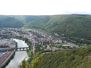
The city is surrounded by forests, about 25 km north of Charleville-Mézières , near the Belgian border at the foot of the Ardennes on a loop of the Meuse (French: Meuse ). The city is also accessed by the Canal de la Meuse ( formerly: Canal de l'Est, branche Nord ), which is formed by the canalized Meuse.
history
The first mention of the place comes from a deed of donation from the year 762, in which Pippin the Younger transferred the place to the Prüm Abbey .
Population development
| year | 1962 | 1968 | 1975 | 1982 | 1990 | 1999 | 2004 | 2009 | 2014 |
|---|---|---|---|---|---|---|---|---|---|
| Residents | 11,244 | 12,156 | 11,607 | 10,465 | 9,371 | 8,963 | 8,089 | 7,236 | 6,586 |
| Source: Cassini and INSEE | |||||||||
Attractions
- Sainte-Anne church from the 17th century, as well as half-timbered buildings such as La Maison Espagnol , which is used as a museum .
- Revin pumped storage power plant operated by Électricité de France (EdF).
Web links
Commons : Revin - collection of images, videos and audio files
