Gué-d'Hossus
| Gué-d'Hossus | ||
|---|---|---|

|
|
|
| region | Grand Est | |
| Department | Ardennes | |
| Arrondissement | Charleville-Mezieres | |
| Canton | Rocroi | |
| Community association | Vallées and Plateau d'Ardenne | |
| Coordinates | 49 ° 57 ' N , 4 ° 32' E | |
| surface | 5.23 km 2 | |
| Residents | 526 (January 1, 2017) | |
| Population density | 101 inhabitants / km 2 | |
| Post Code | 08230 | |
| INSEE code | 08202 | |
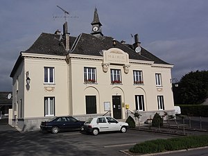
 Town hall (Mairie) of Gué-d'Hossus |
||
Gué-d'Hossus is a French commune with 526 inhabitants (as of January 1, 2017) in the Ardennes department in the Grand Est region (before 2016 Champagne-Ardenne ). It belongs to the arrondissement Charleville-Mézières , the canton Rocroi and the municipality association Vallées et Plateau d'Ardenne .
geography
The municipality is located in the Ardennes Regional Nature Park, founded in 2011 . Gué-d'Hossus is surrounded by the canton capital Rocroi in the east and south, by the neighboring municipality of Taillette in the west and by the Belgian municipality of Couvin in the north.
history
During the First World War , the village was destroyed by the German army on August 26, 1914.
Population development
| year | 1962 | 1968 | 1975 | 1982 | 1990 | 1999 | 2005 | 2015 |
| Residents | 631 | 543 | 452 | 500 | 525 | 504 | 511 | 529 |
| Source: Cassini and INSEE | ||||||||
Attractions
- Saint-Luc church
Web links
Commons : Gué-d'Hossus - collection of images, videos and audio files

