Regniowets
| Regniowets | ||
|---|---|---|

|
|
|
| region | Grand Est | |
| Department | Ardennes | |
| Arrondissement | Charleville-Mezieres | |
| Canton | Rocroi | |
| Community association | Ardennes Thiérache | |
| Coordinates | 49 ° 56 ' N , 4 ° 26' E | |
| surface | 18.27 km 2 | |
| Residents | 391 (January 1, 2017) | |
| Population density | 21 inhabitants / km 2 | |
| Post Code | 08230 | |
| INSEE code | 08355 | |
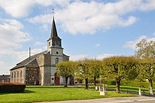
 Town hall (Mairie) of Regniowez |
||
Regniowez is a French commune with 391 inhabitants (as of January 1, 2017) in the Ardennes department in the Grand Est region (until 2015 Champagne-Ardenne ). It belongs to the Arrondissement Charleville-Mézières , the canton Rocroi and the Ardennes Thiérache municipal association .
geography
The place is in the Ardennes Regional Nature Park, founded in 2011 . Regniowez is surrounded by the neighboring communities Taillette in the east, Éteignières in the southeast and south, Neuville-lez-Beaulieu in the west and the Belgian communities Chimay in the northwest and Couvin in the northeast.
The former NATO airfield Rocroi-Regniowez Aerodrome , built in 1956, served the Royal Canadian Air Force until 1967 as an air base for the 1st Canadian Air Division stationed at Montmédy-Marville airfield .
Population development
| year | 1962 | 1968 | 1975 | 1982 | 1990 | 1999 | 2007 | 2015 |
| Residents | 416 | 344 | 355 | 357 | 366 | 396 | 387 | 398 |
| Source: Cassini and INSEE | ||||||||
Attractions
- Sainte-Trinité church
Web links
Individual evidence
- ^ "France-Air-NATO" portal dedicated to the NATO air bases built in France during the Cold War. Retrieved December 25, 2018 (French).

