
Neuville-lez-Beaulieu
| Neuville-lez-Beaulieu | ||
|---|---|---|

|
|
|
| region | Grand Est | |
| Department | Ardennes | |
| Arrondissement | Charleville-Mezieres | |
| Canton | Rocroi | |
| Community association | Ardennes Thiérache | |
| Coordinates | 49 ° 52 ′ N , 4 ° 20 ′ E | |
| height | 220–338 m | |
| surface | 35.92 km 2 | |
| Residents | 335 (January 1, 2017) | |
| Population density | 9 inhabitants / km 2 | |
| Post Code | 08380 | |
| INSEE code | 08319 | |
| Website | http://mairie-rimogne.fr/ | |
_1%C3%A8re_mairie_La_Neuville_aux_Tourneurs.JPG) Town hall (Mairie) of Neuville-lez-Beaulieu (in La Neuville-aux-Tourneurs) |
||

Neuville-lez-Beaulieu is a French commune with 335 inhabitants (as of January 1, 2017) in the Grand Est region in the Ardennes department . It is located in the arrondissement of Charleville-Mézières and is part of the canton of Rocroi .
The municipality consists of the localities of Beaulieu and La Neuville-aux-Tourneurs .
geography
Neuville-lez-Beaulieu is located about 30 kilometers west-northwest of Charleville-Mézières in the Ardennes Regional Nature Park on the rivers Sormonne and Petit Gland , which is still called Ruisseau de Bosneau here . Neuville-lez-Beaulieu is surrounded by the neighboring communities of Chimay (Belgium) in the north, Regniowez in the north-east, Éteignières in the east, Auvillers-les-Forges in the east and south-east, Antheny in the south and south-west, Tarzy in the west and south-west and Signy-le -Petit in the west and northwest.
Population development
| year | 1962 | 1968 | 1975 | 1982 | 1990 | 1999 | 2006 | 2013 |
| Residents | 352 | 374 | 374 | 360 | 298 | 265 | 311 | 348 |
| Source: Cassini and INSEE | ||||||||
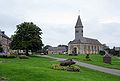
Attractions
- Beaulieu Church
- Church of La Neuville-aux-Tourneurs
- Town halls
Church of La Neuville-aux-Tourneurs

Beaulieu Church

Beaulieu Town Hall

_%C3%A9glise_de_Beaulieu_03.JPG)
_2%C3%A8me_mairie,_Beaulieu.JPG)