
Prez
| Prez | ||
|---|---|---|

|
|
|
| region | Grand Est | |
| Department | Ardennes | |
| Arrondissement | Charleville-Mezieres | |
| Canton | Signy-l'Abbaye | |
| Community association | Ardennes Thiérache | |
| Coordinates | 49 ° 48 ' N , 4 ° 21' E | |
| surface | 12.4 km 2 | |
| Residents | 136 (January 1, 2017) | |
| Population density | 11 inhabitants / km 2 | |
| Post Code | 08290 | |
| INSEE code | 08344 | |
_mairie.JPG) Town hall ( Mairie ) of Prez |
||

Prez is a French commune with 136 inhabitants (as of January 1, 2017) in the Ardennes department in the Grand Est region (before 2016 Champagne-Ardenne ). It belongs to the arrondissement Charleville-Mézières , the canton Signy-l'Abbaye (until 2015 Rumigny ) and the municipality association Ardennes Thiérache .
geography
The municipality is located in the Ardennes Regional Nature Park, founded in 2011 . Prez is surrounded by the neighboring communities of Aouste in the west, Estrebay in the northwest, Flaignes-Havys in the northeast and east, Logny-Bogny in the southeast and Liart in the south. It is crossed by the river Aube , a tributary of the Ton .
Population development
| year | 1962 | 1968 | 1975 | 1982 | 1990 | 1999 | 2007 | 2013 | 2016 |
| Residents | 111 | 97 | 130 | 137 | 105 | 112 | 140 | 138 | 139 |
| Source: Cassini and INSEE | |||||||||
Attractions
- Fortified church of Saint-Martin, built in the 12th century
- Ferme du Maipas, fortress construction from the early 17th century, monument historique since 1926
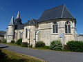
Saint Martin Church

Ferme du Maipas
_%C3%A9glise,_chevet.JPG)

Web links
Commons : Prez - collection of images
Individual evidence
- ↑ Entry no. PA00078482 in the Base Mérimée of the French Ministry of Culture (French)