
Étrépigny
| Étrépigny | ||
|---|---|---|
.svg)
|
|
|
| region | Grand Est | |
| Department | Ardennes | |
| Arrondissement | Charleville-Mezieres | |
| Canton | Nouvion-sur-Meuse | |
| Community association | Ardenne metropolis | |
| Coordinates | 49 ° 41 ′ N , 4 ° 45 ′ E | |
| height | 159-275 m | |
| surface | 4.23 km 2 | |
| Residents | 291 (January 1, 2017) | |
| Population density | 69 inhabitants / km 2 | |
| Post Code | 08160 | |
| INSEE code | 08158 | |
 Town hall (Mairie) of Étrépigny |
||

Étrépigny is a French commune with 291 inhabitants (as of January 1, 2017) in the Ardennes department in the Grand Est region (until 2015 Champagne-Ardenne ). It belongs to the arrondissement Charleville-Mézières , the canton Nouvion-sur-Meuse (until 2015: canton Flize ) and the municipality association Ardenne Métropole . The inhabitants are called Sterpine .
geography
Étrépigny is surrounded by the neighboring communities Chalandry-Elaire in the north, Flize (with Flize, Boutancourt , Élan and Balaives-et-Butz ) in the south, east and west and Saint-Marceau in the north-west.
Population development
| year | 1962 | 1968 | 1975 | 1982 | 1990 | 1999 | 2006 | 2011 | 2016 |
|---|---|---|---|---|---|---|---|---|---|
| Residents | 183 | 161 | 154 | 231 | 217 | 217 | 263 | 261 | 285 |
| Source: Cassini and INSEE | |||||||||
Attractions
- Saint-Julien church
- lock

Saint-Julien church
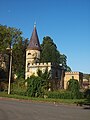
lock


Personalities
- Jean Meslier (1664–1729), priest and enlightener
Web links
Commons : Étrépigny - Collection of images, videos and audio files