
Barbaise
| Barbaise | ||
|---|---|---|
|
||
| region | Grand Est | |
| Department | Ardennes | |
| Arrondissement | Charleville-Mezieres | |
| Canton | Signy-l'Abbaye | |
| Community association | Crêtes Préardennaises | |
| Coordinates | 49 ° 40 ′ N , 4 ° 35 ′ E | |
| surface | 6.68 km 2 | |
| Residents | 101 (January 1, 2017) | |
| Population density | 15 inhabitants / km 2 | |
| Post Code | 08430 | |
| INSEE code | 08047 | |
 View of Barbaise |
||

Barbaise is a French commune with 101 inhabitants (as of January 1, 2017) in the Ardennes department in the Grand Est region (until 2015 Champagne-Ardenne ). It belongs to the arrondissement Charleville-Mézières , the canton Signy-l'Abbaye and the local association Crêtes Préardennaises founded in 1995 .
geography
The municipality is located around 15 kilometers northeast of the Charleville-Mézières prefecture . Barbaise is surrounded by the neighboring municipalities of Raillicourt in the southeast, Jandun in the southwest, west and northwest, Gruyères in the north and the municipality of Touligny in the canton of Nouvion-sur-Meuse in the northeast.
Between December 29, 1974 and December 31, 1990, Barbaise was part of the Raillicourt municipality (name of the merged municipality: Raillicourt-Barbaise ).
Population development
| year | 1954 | 1962 | 1968 | 1999 | 2006 | 2008 | 2011 | 2013 | 2016 | |||||
|---|---|---|---|---|---|---|---|---|---|---|---|---|---|---|
| Residents | 100 | 96 | 69 | 106 | 105 | 105 | 101 | 92 | 97 | |||||
| Sources: Cassini and INSEE | ||||||||||||||
Attractions
- Sainte-Anne church from the 18th and 19th centuries
- War memorial

Church of Sainte-Anne
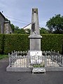
War memorial

