Estrebay
| Estrebay | ||
|---|---|---|

|
|
|
| region | Grand Est | |
| Department | Ardennes | |
| Arrondissement | Charleville-Mezieres | |
| Canton | Signy-l'Abbaye | |
| Community association | Ardennes Thiérache | |
| Coordinates | 49 ° 50 ′ N , 4 ° 21 ′ E | |
| surface | 9.37 km 2 | |
| Residents | 74 (January 1, 2017) | |
| Population density | 8 inhabitants / km 2 | |
| Post Code | 08260 | |
| INSEE code | 08154 | |
 Estrebay Town Hall (Mairie) |
||
Estrebay is a French commune with 74 inhabitants (as of January 1, 2017) in the Ardennes department in the Grand Est region (before 2016: Champagne-Ardenne ). It belongs to the arrondissement Charleville-Mézières , the canton Signy-l'Abbaye (until 2015: Rumigny ) and the municipality association Ardennes Thiérache .
geography
The municipality is located in the Ardennes Regional Nature Park, founded in 2011 . Estrebay is surrounded by the neighboring communities of Champlin in the west and northwest, Girondelle in the north, Flaignes-Havys in the east, Prez in the southeast and Aouste in the south.
Population development
| year | 1962 | 1968 | 1975 | 1982 | 1990 | 1999 | 2009 | 2016 | |
| Residents | 149 | 130 | 98 | 81 | 66 | 69 | 77 | 70 | |
| Source: Cassini and INSEE | |||||||||
Attractions
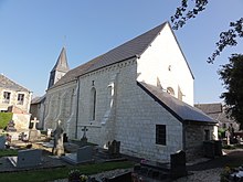
- Notre-Dame church
Web links
Commons : Estrebay - collection of pictures, videos and audio files

