
Flaignes-Havys
| Flaignes-Havys | ||
|---|---|---|

|
|
|
| region | Grand Est | |
| Department | Ardennes | |
| Arrondissement | Charleville-Mezieres | |
| Canton | Signy-l'Abbaye | |
| Community association | Ardennes Thiérache | |
| Coordinates | 49 ° 49 ′ N , 4 ° 24 ′ E | |
| surface | 13.7 km 2 | |
| Residents | 121 (January 1, 2017) | |
| Population density | 9 inhabitants / km 2 | |
| Post Code | 08260 | |
| INSEE code | 08169 | |
_mairie.JPG) Town hall (Mairie) of Flaignes-Havys |
||

Flaignes-Havys is a French commune with 121 inhabitants (as of January 1, 2017) in the Ardennes department in the Grand Est region (before 2016: Champagne-Ardenne ). It belongs to the arrondissement Charleville-Mézières , the canton Signy-l'Abbaye (until 2015: Rumigny ) and the municipality association Ardennes Thiérache .
geography
The municipality is located in the Ardennes Regional Nature Park, founded in 2011 . Flaignes-Havys is surrounded by the neighboring communities of Marby in the northeast, Cernion in the southeast, Logny-Bogny in the south, Prez in the southwest, Estrebay in the west, Girondelle in the northwest and the municipality of Maubert-Fontaine in the canton of Rocroi in the north. The river Aube , a tributary of the Ton, rises in the local area .
history
During the Battle of Rocroi in 1643, the villages of Flaignes-les-Oliviers and Havys were partially burned down.
On March 3, 1982 Flaignes-les-Oliviers and Havys merged to form today's municipality of Flaignes-Havys.
Population development
| year | 1962 | 1968 | 1975 | 1982 | 1990 | 1999 | 2005 | 2016 | |
| Residents | 145 | 140 | 167 | 160 | 133 | 132 | 121 | 120 | |
| Source: Cassini and INSEE | |||||||||
Attractions
- Saint Laurent fortified church in Flaignes, built in the 17th century.
- Saint-Géry fortified church in Havys, built in the 17th century.
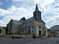
Saint Laurent church in Flaignes

Saint-Géry church in Havys
_%C3%A9glise_Saint-Laurent,_ext%C3%A9rieur_01.JPG)
_%C3%A9glise_de_Havys,_vue_du_nord.JPG)