Kane County, Illinois
 Kane County Courthouse |
|
| administration | |
|---|---|
| US state : | Illinois |
| Administrative headquarters : | Geneva |
| Address of the administrative headquarters: |
County Government Center 719 S Batavia Avenue Geneva, IL 60134-3077 |
| Foundation : | January 16, 1836 |
| Made up from: | LaSalle County |
| Area code : | 001 630 |
| Demographics | |
| Residents : | 515,269 (2010) |
| Population density : | 486.5 inhabitants / km 2 |
| geography | |
| Total area : | 1357 km² |
| Water surface : | 297.8 km² |
| map | |
| Website : countyofkane.org | |
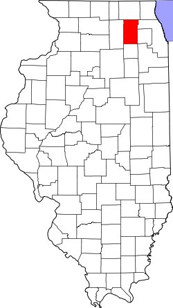
The Kane County is a county in the US -amerikanischen State Illinois . In 2010 , the county had 515,269 people and a population density of 486.5 people per square kilometer. The county seat is Geneva .
Kane County is part of the Chicago metropolitan area .
geography
The county is located in northeast Illinois in the western suburbs of Chicago . It has an area of 1357, of which 298 square kilometers are water surface. The following neighboring counties border Kane County:
| McHenry County | ||
| DeKalb County |

|
Cook County DuPage County |
| Kendall County | Will County |
Rivers in the county
history
The area of what is now Kane County was first reached by European explorers through the Marquette-Joliet Expedition . The explorer La Salle and his lieutenant Tonti later claimed the land for France . In 1717 the land was placed under the care of Louisiana and remained in French possession until the end of the French and Indian War . By signing the treaty in Paris , the country was ceded to the British. British control ended in 1778 when George Rogers Clark crossed the southwest border at Kaskaskia and Cahokia .
In 1818 Illinois got its sovereignty and the area of what would later become Kane County was only known to be Indians. The invasion of the colonists forced the Indians to migrate towards Iowa . In 1832 they tried to recapture their former country. In response, army troops were dispatched and the Indian offensive was put down. Over the next two years, droves of new colonists came.
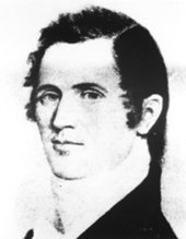
On January 16, 1836, Kane County was formed from parts of LaSalle County . It was named after Elias Kent Kane , a respected lawyer, member of Congress, US Secretary of State and US Senator from Illinois. The first county administration was LaFox, later it became Vienna. The first courthouse was built in 1837, which was replaced by a stone courthouse in 1844.
The years following the Civil War were marked by a sudden increase in the population looking for work. Another population surge was triggered by the newly built railroad that connected the Mississippi River with the new industrial area of Chicago . Chicago hotels were a major source of milk, butter, and cheese in northern Kane County. The railway ensured fast transport for the fresh dairy products that were loaded into the city every day.
On the night of March 13, 1890, Kane County lost one of its most treasured buildings when a fire destroyed the courthouse. Fortunately, the most important documents were deposited in a fire-proof vault. The new courthouse and prison has four floors and is still standing today. From 1890 to 1940 the population doubled from 65,000 to 130,000 and again from 1940 to 1970 to 260,000.
Territorial development
| Population development | |||
|---|---|---|---|
| Census | Residents | ± in% | |
| 1840 | 6501 | - | |
| 1850 | 16,703 | 156.9% | |
| 1860 | 30,062 | 80% | |
| 1870 | 39.091 | 30% | |
| 1880 | 44,939 | 15% | |
| 1890 | 65,061 | 44.8% | |
| 1900 | 78,792 | 21.1% | |
| 1910 | 91,862 | 16.6% | |
| 1920 | 99,499 | 8.3% | |
| 1930 | 125,327 | 26% | |
| 1940 | 130.206 | 3.9% | |
| 1950 | 150,388 | 15.5% | |
| 1960 | 208.246 | 38.5% | |
| 1970 | 251.005 | 20.5% | |
| 1980 | 278.405 | 10.9% | |
| 1990 | 317,471 | 14% | |
| 2000 | 404.119 | 27.3% | |
| 2010 | 515.269 | 27.5% | |
| Before 1900 1900–1990 2000 2010 | |||
Demographic data
According to the 2010 census , Kane County had 515,269 people in 169,528 households. The population density was 486.5 inhabitants per square kilometer. Statistically, there were 2.97 people in each of the 169,528 households.
The racial the population was composed of 87.4 percent white, 6.1 percent African American, 1.0 percent Native American, 3.7 percent Asian, 0.1 percent Polynesian and other ethnic groups; 1.7 percent were descended from two or more races. Hispanic or Latino of any race was 31.1 percent of the population regardless of ethnicity.
28.7 percent of the population were under 18 years old, 61.3 percent were between 18 and 64 and 10.0 percent were 65 years or older. 50.1 percent of the population was female.
The median income for a household was 69,496 USD . The per capita income was $ 29,864. 10.1 percent of the population lived below the poverty line.
Localities in Kane County
1 - partly in DuPage , Kendall and Will County
2 - partly in DuPage County
3 - partly in Cook County
4 - partly in McHenry County
5 - partly in Cook , Lake and McHenry County
6 - partly in Cook and DuPage County
7 - partly in DeKalb County
8 - partly in Kendall County
structure
Kane County is divided into 16 townships :
|
|
See also
Individual evidence
- ↑ GNIS-ID: 424246. Retrieved on February 22, 2011 (English).
- ↑ a b c U.S. Census Bureau, State & County QuickFacts - Kane County, IL ( Memento of the original from July 12, 2011 on WebCite ) Info: The archive link was automatically inserted and has not yet been checked. Please check the original and archive link according to the instructions and then remove this notice. Retrieved December 12, 2012
- ↑ a b National Association of Counties.Retrieved December 12, 2012
- ^ US Census Bureau - Census of Population and Housing.Retrieved March 15, 2011
- ^ Extract from Census.gov.Retrieved February 15, 2011
- ↑ Missouri Census Data Center - Illinois ( page no longer available , search in web archives ) Info: The link was automatically marked as defective. Please check the link according to the instructions and then remove this notice. Retrieved December 12, 2012
Web links
Coordinates: 41 ° 57 ′ N , 88 ° 26 ′ W


