
Morosaglia
| Morosaglia | ||
|---|---|---|
.svg)
|
|
|
| region | Corsica | |
| Department | Upper Corsica | |
| Arrondissement | Corte | |
| Canton | Golo-Morosaglia (main town) | |
| Community association | Pasquale Paoli | |
| Coordinates | 42 ° 26 ' N , 9 ° 18' E | |
| height | 182-1,249 m | |
| surface | 24.45 km 2 | |
| Residents | 1,043 (January 1, 2017) | |
| Population density | 43 inhabitants / km 2 | |
| Post Code | 20218 | |
| INSEE code | 2B169 | |
 Morosaglia with the village church |
||

Morosaglia is a commune in the Haute-Corse department on the island of Corsica in France . It belongs to the Arrondissement of Corte and the canton of Golo-Morosaglia , whose main town (Chef-lieu) it is.
geography
The municipality is located in the Castagniccia , a hilly landscape on Corsica. Neighboring municipalities are Canavaggia , Valle-di-Rostino and Castello-di-Rostino in the north, Ortiporio in the northeast, Giocatojo in the east, Gavignano in the southeast, Castineta in the south, San-Gavino-di-Tenda in the southwest, Piedigriggio in the west and Moltifao in the Northwest.
Morosaglia includes the district of Ponte Leccia , which contains a train station and is passed by the Golo .
Population development
| 1962 | 1968 | 1975 | 1982 | 1990 | 1999 | 2006 | 2017 |
|---|---|---|---|---|---|---|---|
| 550 | 694 | 750 | 854 | 883 | 1008 | 1058 | 1043 |

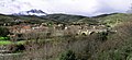
Panorama of Ponte Leccia
The Ponte Leccia, a bridge over the Golo in the district of the same name
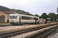
Chemins de fer de la Corse diesel railcars at Ponte Leccia station
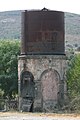
Water tower, a relic from the age of the steam locomotives


