
Trévol
| Trévol | ||
|---|---|---|

|
|
|
| region | Auvergne-Rhône-Alpes | |
| Department | Allier | |
| Arrondissement | Moulins | |
| Canton | Yzeure | |
| Community association | Moulins Community | |
| Coordinates | 46 ° 38 ′ N , 3 ° 18 ′ E | |
| height | 197-264 m | |
| surface | 40.84 km 2 | |
| Residents | 1,625 (January 1, 2017) | |
| Population density | 40 inhabitants / km 2 | |
| Post Code | 03460 | |
| INSEE code | 03290 | |
| Website | http://mairie-trevol.planet-allier.com/ | |
 View of Trévol from the air |
||

Trévol is a French commune with 1,625 inhabitants (as of January 1 2017) in the department of Allier in the region Auvergne Rhône-Alpes ; it belongs to the arrondissement of Moulins and the canton of Yzeure .
geography
Trévol is located in the Sologne bourbonnaise landscape , around seven kilometers north-north-west of Moulins . The Allier limits the community to the west. Trévol is surrounded by the neighboring municipalities of Aurouër in the north, Saint-Ennemond in the north-east, Gennetines in the east, Avermes in the south, Montilly in the west and south-west and Villeneuve-sur-Allier in the west and north-west.
The National Route 7 runs through the municipality .
Population development
| year | 1962 | 1968 | 1975 | 1982 | 1990 | 1999 | 2006 | 2012 |
| Residents | 847 | 812 | 1.004 | 1,255 | 1.405 | 1,366 | 1,564 | 1,678 |
| Source: Cassini and INSEE | ||||||||
Attractions
See also: List of the Monuments historiques in Trévol
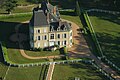
- Avrilly Castle from the 15th century, a historic monument since 1923
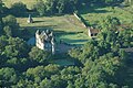
- Les Bédaures castle
- Demoret Castle
- Les Coiffier Castle
- Mirebeau Castle
- House Demou, monument historique since 2003

Avrilly Castle
Les Bédaures castle
Demoret Castle


literature
- Le Patrimoine des Communes de l'Allier. Flohic Editions, Volume 2, Paris 1999, ISBN 2-84234-053-1 , pp. 1102-1106.