
Verneuil-en-Bourbonnais
| Verneuil-en-Bourbonnais | ||
|---|---|---|

|
|
|
| region | Auvergne-Rhône-Alpes | |
| Department | Allier | |
| Arrondissement | Moulins | |
| Canton | Souvigny | |
| Community association | Saint-Pourçain Sioule Limagne | |
| Coordinates | 46 ° 21 ′ N , 3 ° 15 ′ E | |
| height | 234-356 m | |
| surface | 14.14 km 2 | |
| Residents | 244 (January 1, 2017) | |
| Population density | 17 inhabitants / km 2 | |
| Post Code | 03500 | |
| INSEE code | 03307 | |
 View of Verneuil-en-Bourbonnais |
||

Verneuil-en-Bourbonnais is a French municipality with 244 inhabitants (as of January 1 2017) in the department of Allier in the region Auvergne Rhône-Alpes (before 2016 Auvergne ). It belongs to the canton of Souvigny and the Arrondissement of Moulins .
geography
Verneuil-en-Bourbonnais is located in the north of the Auvergne in the historic province of Bourbonnais , about 23 kilometers south-southwest of the city center of Moulins and about 28 kilometers north-northwest of Vichy on the Douzenan river . Verneuil-en-Bourbonnais is surrounded by the neighboring communities of Meillard in the north, Monétay-sur-Allier in the northeast, Contigny in the east, Saulcet in the south and Bransat in the south and west.
Population development
| year | 1962 | 1968 | 1975 | 1982 | 1990 | 1999 | 2006 | 2011 | 2016 |
|---|---|---|---|---|---|---|---|---|---|
| Residents | 399 | 329 | 290 | 250 | 280 | 283 | 253 | 243 | 250 |
| Source: Cassini and INSEE | |||||||||
Attractions
See also: List of Monuments historiques in Verneuil-en-Bourbonnais
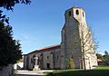
- Notre-Dame-sur-l'Eau church from 10/11 Century, since 1928 Monument historique
- Saint-Pierre Church, a historic monument since 1910
- Castle ruins

Notre-Dame-sur-l'Eau church
Saint-Pierre church

Castle ruins


literature
- Le Patrimoine des Communes de l'Allier . tape 2 . Flohic Editions, Paris 1999, ISBN 2-84234-053-1 , pp. 967-971 .