
Aubigny (Allier)
| Aubigny | ||
|---|---|---|
.svg)
|
|
|
| region | Auvergne-Rhône-Alpes | |
| Department | Allier | |
| Arrondissement | Moulins | |
| Canton | Moulins-1 | |
| Community association | Moulins Community | |
| Coordinates | 46 ° 41 ′ N , 3 ° 10 ′ E | |
| height | 189-255 m | |
| surface | 17.14 km 2 | |
| Residents | 139 (January 1, 2017) | |
| Population density | 8 inhabitants / km 2 | |
| Post Code | 03000 | |
| INSEE code | 03009 | |

Aubigny is a French commune of the department Allier with 139 inhabitants (as of January 1 2017) in the region of Auvergne Rhône-Alpes . Administratively, it is assigned to the canton of Moulins-1 (until 2015: canton of Moulins-Ouest ) and the arrondissement of Moulins . The inhabitants are called Albania .
geography
Aubigny is located in the north of the Auvergne in the historical province of Bourbonnais about 17 kilometers northwest of the city center of Moulins on the banks of the Allier , which borders the municipality to the east. Aubigny is surrounded by the neighboring communities of Chantenay-Saint-Imbert in the north, Tresnay in the north and northeast, Villeneuve-sur-Allier in the east, Bagneux in the south and southeast, Agonges in the south, Couzon in the southwest and Saint-Léopardin-d'Augy in the West.
Population development
| year | 1962 | 1968 | 1975 | 1982 | 1990 | 1999 | 2006 | 2013 |
|---|---|---|---|---|---|---|---|---|
| Residents | 133 | 151 | 131 | 100 | 101 | 103 | 118 | 153 |
| Source: Cassini and INSEE | ||||||||
Attractions
See also: List of Monuments historiques in Aubigny (Allier)
- Saint-Genès church from the 12th century, a historic monument since 1947
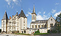
- Aubigny castle from the 19th century
- 19th century castle Les Roches in Aubigny
- 19th century Le Réray castle
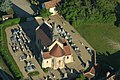
Saint-Genès church

Aubigny Castle

Les Roches Castle
Le Réray castle and chapel
_church_04.jpg)
_03.jpg)


literature
- Le Patrimoine des Communes de l'Allier. Flohic Editions, Volume 2, Paris 1999, ISBN 2-84234-053-1 , pp. 837-839.