
Etroussat
| Etroussat | ||
|---|---|---|
.svg)
|
|
|
| region | Auvergne-Rhône-Alpes | |
| Department | Allier | |
| Arrondissement | Moulins | |
| Canton | Gannat | |
| Community association | Saint-Pourçain Sioule Limagne | |
| Coordinates | 46 ° 13 ' N , 3 ° 13' E | |
| height | 265-374 m | |
| surface | 13.03 km 2 | |
| Residents | 655 (January 1, 2017) | |
| Population density | 50 inhabitants / km 2 | |
| Post Code | 03140 | |
| INSEE code | 03112 | |
| Website | http://www.etroussat.fr/ | |

Étroussat is a central French town and municipality ( commune ) with 655 inhabitants (as of January 1, 2017) in the Allier department in the north of the Auvergne-Rhône-Alpes region (before 2016 Auvergne ). It belongs to the Arrondissement of Moulins and the Canton of Gannat (until 2015 Chantelle ). The inhabitants are called Étroussatois .
location
Étroussat is located in the Bourbonnais landscape about 24 kilometers west-northwest of Vichy . Étroussat is surrounded by the neighboring municipalities of Chareil-Cintrat in the north, Bayet in the northeast, Barberier in the east, Saint-Germain-de-Salles in the south and southeast, Ussel-d'Allier in the west and southwest and Fourilles in the northwest.
Population development
| year | 1962 | 1968 | 1975 | 1982 | 1990 | 1999 | 2006 | 2011 | 2016 |
| Residents | 684 | 705 | 672 | 624 | 647 | 605 | 650 | 724 | 636 |
| Source: Cassini and INSEE | |||||||||
Attractions
See also: List of Monuments historiques in Étroussat
- Saint-Georges church with sculpture Madonna and Child ( Monument historique )
- Douzon castle from the 14th century with alterations from the 18th century, monument historique since 1973

Saint-Georges church
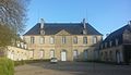
Beauvoir Castle
_2016-03-18.JPG)

literature
- Le Patrimoine des Communes de l'Allier. Flohic Editions, Volume 1, Paris 1999, ISBN 2-84234-053-1 , p. 105.