
Damara supergroup


The Damara supergroup , also known as the Damara sequence , is a lithostratigraphic unit of the supergroup rank , which comprises the deformed and metamorphic sedimentary overburden of the basement units of the Damara belt . It consists of a multitude of layers from different deposition environments and periods.
The formation of the parent rocks, e.g. B. Loose rocks and their sedimentation occurred mainly as a result of the formation of several rift breaks or rift systems between the cratons Congo-São Francisco (abbreviated Congo-SF) and Kalahari in the period of about 780 to 500 million years (abbreviated mya ) during the disintegration of the supercontinent Rodinia to the formation of pannotia .
The name Damara is derived from the name for the African ethnic group Damara , which was originally native to widespread settlement areas in Namibia .
Geographical location and extent
The Damara Belt, on which the Damara Sequence is stored, extends along the west coast of the South Atlantic for about 1,400 km from the Kunene River in the north to the Orange River in the south. The west / east extension from the Atlantic coast inland to the eastern outcrop of the Grootfontein Inliers near the community of Grootfontein is approx. 530 km. The eastern and northern areas of this belt are covered by younger sediments from the Kalahari .
Geodynamic framework
The geodynamic evolution of the Damara Sequence is related to the formation and disintegration of the Rodinia supercontinent. When this had formed around 900 mya, u. a. the cratons Kalahari , Río de la Plata as well as Congo with São Francisco (abbreviated Congo-SF) connected to a land mass.

In the period from 780 to 740 mya originated from Plume events initiated intracontinental grave breaches ( English Rifts ) along a triple junction (triple) between the "African" cratons Congo SF and Kalahari and the "South American" Río de la Plata -Craton. Presumably the triple point is near the Namibian city of Swakopmund in the Erongo region . The rift fractures developed into an ocean floor spread and further to a sea basin , the Adamastor Ocean. He thus separated the cratons Kongo-SF and Kalahari from the Río-de-la-Plata-Kraton.

In connection with rift fractures, a subsidence zone developed in the SW of the Congo-SF craton as a result of tectonically induced expansion. In the further geological development it formed into a deep sedimentary basin , which is called the Owambo Basin. It extends between what is now northern Namibia and southern Angola .
Between the Congo SF and Kalahari cratons several almost parallel intra-continental rift fractures formed in a west-east direction. They formed basins that were flooded with seawater from the Adamastor Ocean as the crust subsided. The Outjo Sea was formed in the northern rift and the Khomas Sea in the southern. In the further geological development the Khomas trough developed in the southern rift, in which a mid-ocean ridge and an ocean floor spread emerged.

At the edges of the cratons Kongo-SF and Kalahari z. T. powerful rock layers in the form of avalanche turbidites marine slopes of the ocean basins slid down and allochthonous were deposited often far away as powerful layers. The turbidites formed on the southern and northern edges of the Damara Belt and in its central area.
For several million years, the rifts served as collecting basins for a wide variety of sediment material , such as river deposits or sands , from which conglomerates , sandstones or quartzites could later form. Volcanic sedimentary layers were also deposited.
The Kaigas Ice Age , the Sturtic Ice Age, the Marino Ice Age and the Gaskiers Ice Age occurred between about 750 and 580 mya, some of which had global spread ( Snowball Earth ). With the melting of the thick ice sheets, enormous amounts of melt water were created , in which carbonates , diamictites or tillites and other sediments were formed. These ice ages and their deposits represent important data for the geochronological determination of the events in the history of the earth.
From 655 mya onwards, the divergence phase was followed by the convergence phase between the Cratonic African and South American continental floes. From 595 to 540 mya the Adamastor Ocean closed, causing the cratons Río de la Plata and Kalahari to collide.
Between 595 and 540 mya the Khomas Sea subducted northwards under the Congo-SF craton. With the approach of the cratons Kongo-SF and Kalahari, the latter partially subducted under the craton Kongo-SF. Its load on the Kalahari craton created a lithospheric depression , which, as the Nama foreland basin, absorbed thick sediments from the eroding surrounding mountains. A bulge of the basement running in WO-direction divides the Nama foreland basin into a northern and southern sub-basin.
Tectono-stratigraphic structure

Based on the tectonic development, stratigraphy , lithostratigraphy and the geological units, the Damara belt is subdivided into several, approximately aligned tectonic-stratigraphic zones. The zones are separated by faults , lineaments , faults or stratigraphic transitions.
From north to south, the zones with the geological units separating them are arranged as follows:
- Northern platform (English Northern Platform )
- Northern margin zone (English Northern Margin Zone ) with the Khorixas Gaseneirob Thrust for
- Northern Zone (English Northern Zone ) with the Autseib Fault / Otjohorongo Thrust for
- Central zones (English Central Zone ) with the Omaruru Lineament between the Northern and the Southern Central Zone with the Okahandja Lineament
- Okahandja Lineament Zone for
- Southern Zone (English Southern Zone ) with the Matchless Amphibolite Member within this zone and the Gomab River Line for
- Southern edge zone (English Southern Margin zone ) with gomab River lineament and the frontal Thrust
- Nama foreland basin
Basement and Inlier
Cratonic floor

The basement (English Basement ) of the Damara belt forms the base of the sedimentary Damara sequence. It essentially consists of the kratonnischen floor, mostly archaic age, like the cratons Kongo-SF and Kalahari as well as the overlying Khan River-Detachment. As a shear, this forms a ductile shear zone and separates the granitic gneiss subsoil of the cratonic storey from the metamorphic Damara sequence. The layer thickness of this shear zone is between 50 m and 2 km.
Inlier
Connected to the basement are several inliers (enclaves). These are either partially exposed locally or covered by layers of sediment. They probably form large extensions of the kratonic floor below the Damara sequence. The inliers arose from around 2,000 mya in the course of the Eburnian orogeny on the active margins of the cratons of the Congo-SF and Kalahari. During the Kibara orogeny from 1,500 mya further magmatic phases occurred . The most important are the Kamanjab inlier, the Grootfontein inlier and the Abbabis inlier, which are assigned to the Congo-SF craton, while the Rehoboth inlier developed on the edge of the Kalahari craton.
The Kamanjab Inlier, named after the village of Kamanjab in the Kunene Region, extends in the southeast of the Kaoko Belt and is surrounded to the north and east by the Northern Platform and south by the Northern Zone of the Damara Belt or Damara -Sequence. It formed from around 1,860 mya.
The Grootfontein-Inlier got its name from the municipality of Grootfontein in the Otjozondjupa region and is located at the eastern junction of the Northern Platform with the Northern Zone. Its creation began from around 2,022 mya.
The Abbabis Inlier is located in the central zone of the Damara Belt. Its name refers to the disused Abbabis train station in the Erongo region . The inlier appears in the form of several dome-shaped outcrops , which developed as a result of compression and contraction of the cratonic floor. Its age is stated to be around 1,925 mya.
The Rehoboth Inlier is named after the town of Rehoboth in the Hardap region . It originated on the northwestern edge of the Kalahari craton and is divided into the Rehoboth sequence and the Sinclair sequence. The Rehoboth sequence developed during the Eburian orogeny between 1,800 and 1,600 mya, while the Sinclair sequence developed between 1,200 and 1,000 mya and thus falls within the period of the Kibarian orogeny. These volcanic sedimentary deposits occur in outcrops in the southern rim zone.
For the emergence of the Rehoboth sequence, a tectonic formation space on an active continental margin is postulated with island arc and back arc basin formation and their subsequent attachment to the Kalahari craton. The Rehoboth sequence, which is up to 15 km thick, consists of felsic and andesitic volcanic rocks , in which quartzites , phyllites , calcium silicate and various conglomerates are inserted.
The overlying Sinclair sequence probably developed in an intracontinental spreading regime with rift formation. It contains four grave break cycles sediment layers of clastic sediments, primarily sand stones and slate and bimodal volcanic rocks ( English Bimodal volcanismus ), both mafic and felsic Magmenanteile within a Lavaaustritts include. The most recent layer contains quartzite and slate. The Sinclair sequence forms a chain of protruding outcrops along the northwestern edge of the Kalahari craton.
Damara sequence
The information about the earliest onset of sedimentation in the Damara Belt varies between 1,000 and 850 mya. These relate to collision and disintegration processes of the supercontinent Rodinia , such as orogenesis and the associated erosions .


The evolution of the Damara sequence in the narrower sense is causally related to the formation of the intracontinental rift breaks between the cartons of the Congo-SF and Kalahari around 780 mya. Various ditch - Horst systems, half ditch (English half ditch ), ridges and faults developed . tectonic and erosive processes caused sediments to develop from the affected parent rock. These cover the lower geological levels according to their regional geographic development and distribution.
More reliable information about the sedimentation and its age was provided by geochronological measurements on igneous rocks that intruded into or overlaid the sediments . They document a minimum age of around 756 mya. The end of the sedimentation phase is dated between 520 and 510 mya.
The Damara sequence consists of sediments, some of which have very different rock properties , which were deposited in various deposition environments of the rift basins on the mainland (terrestrial), in flowing waters ( fluvial ), in inland waters (limnic) or in the sea (marine).
The sediment layers are mostly irregular on the respective lower floors and also one below the other. They were subject to various deformations and metamorphoses . These were mainly initiated by tectonic processes and were in the individual zones z. Sometimes very different.
According to the spatial and structural occurrence of the deposits, the Damara sequence is lithostratigraphically divided into different groups , subgroups and formations as well as further units. They reflect the deposition environments and periods of the sediments and are not equally present in all areas of the Damara orogen. The structure is also not standardized, as it often varies between different publications. The age information in the literature also often differs considerably.
Nosib group
The nosib group forms the lowest lithostratigraphic unit of the Damara sequence. The sediments were deposited over a period of about 780 to 740 mya.

Schematic profile of a flat coast

Schematic profile of a continental margin with shelf area

Schematic representation of the sedimentary layer shift in a transgression (above) and a regression (below)

The layers that were initially sedimented terrestrially came under shallow marine cover in the further development of the rift fractures. The development began on the northwestern edge of the Kalahari Craton and includes terrestrial, fluvial and limnic up to marine deposition environments of tidal areas on flat coasts . In salt plains , also known as playa plains, or in shallow Sabcha basins that are sometimes filled with water , dolomitic carbonates and sediments were able to develop under formation conditions with hypersaline, highly concentrated salt contents.
A full marine development of the upper Nosib formation is u. a. documented in the 1.5 km thick Hakos thrust cover within the Hakos Mountains . This blanket contains shelf facies with thick layers of quartzites and black schists as well as quartzitic marine turbidity currents . At the southern edge of the Congo-SF craton, a shift in the marine coastline from west to east transgression has also been demonstrated. A sequence of Tillitic glacial deposits shows clear marine influences in the west, while these decrease further to the east and ultimately do not occur.
In the Damara Belt, the Nosib group is present in all other zones except for the Southern Zone and the Okahandja Lineament Zone. The basal, lowest formation also does not exist within the northern area of the North Central Zone, where overall the Nosib group is thinning.
The Nosib group forms layers up to 7 km thick. However, these vary greatly between the individual zones of the Damara Belt, depending on the evolution and structure of the semi-parallel rift fractures, the ridges or tectonic clumps and faults they contain . The deposits are particularly thick in the southern peripheral zone up to 6 km and in the northern zone with more than 6.5 km, while in the northern central zone the layer is relatively thin.
The lowest and therefore oldest formation is widespread in the Damara belt. Their rocks were initially sedimented on the southwestern edge of the Congo-SF craton and the northwestern edge of the Kalahari craton. The southwestern area of the Congo-SF craton is characterized by the large Owambo Basin, which forms the northern platform of the Damara Belt.
The sedimented rocks composed of mostly coarse to medium coarse and relatively poorly sorted, with a large range of particle size fractions occurring siliciclastic with most typical pale brown to pale pink coloring. It contains feldspar -containing quartzites , arkoses and arenites transported by fluvial transport , conglomerates of various compositions, as well as micaceous and feldspar -containing gneiss in terrestrial, fluvial and limnic deposit environments . Gravel deposits as well as parallel and sloping stratifications are clear characteristics of sediment transport through flowing waters.
- Several magmatic events occurred in the Nosib group in the area of the Northern Rim Zone and the Northern Zone, which represent the southwestern edge of the Congo-SF craton and border the Eastern Kaoko Zone and Ugab Zone . The rocks released in the process are not counted among the sediments but as igneous rocks . They form spatially separated sequences of different ages and are of outstanding importance for the regional geology of the Damara orogen and the understanding of its development.
The older is the 50 km² large oas intrusion in the northern rim zone with an age of 756 mya. The Oas intrusion thus determines the minimum age of the lower nosib formation in this area. The syenites with mineral components of hornblende and quartz are characteristic . This intrusion penetrated on the one hand the old gneiss of the local relatively small Welwitschia inlier located south of the Kamanjab Inlier and on the other hand the feldspar-containing quartzites of the lower Nosib formation. To the south it borders on the carbonatic and fine clastic layers of the Swakop group.
To the west of the Oas intrusion, rhyolithic pyroclastic ash flows , tufa layers , ignimbrites and gray, quartz and feldspar-rich porphyries ( Bostonites ) were deposited in the upper Nosib formation . These volcanic rocks are not in contact with the oas intrusion, but are of a comparable age.

Two other magmatic sequences formed 60 km southeast of the Oas intrusion. The first sequence consists mainly of potassium-accentuated alkaline rhyolitic pyroclastic ash flows, ignimbrites and gray, quartz- and feldspar-rich porphyries with a thickness of 6.6 km. They form the majority of the 150 km² Summas Mountains-Inlier. This sequence correlates with that to the west of the Oas intrusion. The age dates to 746 mya. On the northeast side of this inlier, sodium-accentuated alkaline rhyolite lava flows , tuffs and andesitic porphyries were deposited , which are cut by a fault zone . The age is given as 747 mya.
- In the Northern Zone, the upper Nosib Formation is dominated by feldspar-containing quartzites and conglomerates, but not in all areas of this zone. South of Kamanjab-inlier separates a during a cold period resulting diamiktitische sediment layer, the upper Nosib formation of the auflagernden, basal formation of omeg group. This sediment layer with a thickness of up to 130 m consists of a feldspar and iron-containing muddy-sandy matrix with a dark color. It contains scattered, rounded pebbles to boulders, large fragments of rock that come from the underlying Nosib formation. The age of this layer dates to 746 mya and can therefore be assigned to the Kaigas Ice Age .
- In the central zone and the southern edge zone, the lower nosib deposits that are otherwise present hardly occur. The upper Nosib formation consists of rocks with carbonatic to marly facies . The central zone is characterized by feldspathic , pyroxenhaltige and amphibolithaltige quartzites and gneiss and several thin layers of conglomerates and siliciclastic and biotithaltige and amphibolithaltige mica . The sediments enclose the biting (emerging) domes of the basement. In the southern edge zone, in addition to quartzites and conglomerates, phyllites and dolomite rocks are also represented. In both zones there are indications of differently pronounced evaporation rocks ( evaporites ) which were excreted in supersaturated solutions.
Otavi group
The Otavi group covers the uppermost Nosib formation or is located in places directly on the basement. It encloses the Kamanjab Inlier to the north, south and east and thus sedimented on the southwestern edge of the Congo-SF craton in a marine environment of shelf areas . In terms of regional structure, it is the Northern Platform with the Otavi Mountains , the Northern Edge Zone and the Northern Zone of the Damara Belt and the Eastern Kaoko Zone with the Eastern Kaokoveld . The sediments reach thicknesses of up to 6 km. To the east, the Otavi Group is bounded by the sediments of the Nosib Group, which were deposited on the Northern Platform in the Owambo Basin. From the central zone the Otavi group thins out; further south it is no longer represented.
The deposition of the Otavi sediments began after around 760 mya and ended around 600 mya.
- The basal omeg subgroup contains as the lowest formation a glacial diamictite horizon from little or non-sorted conglomerates , brecciation , silt , feldspathic sandstone and bands ores (English Banded iron formation BIF ). This 130 m thick formation is located in places directly on the basement mountains of the Kamanjab and Grootfontein Inlier or locally on the uppermost formation of the Nosib group. The age is given as 746, which falls during the Kaigas Ice Age .

Above is a 1.7 km thick carbonate platform , consisting of formations with alternating layers of massive dolomite stones , banked limestones , slates , cherts , stromatolite limestones and oolites as well as various breccias . These formations developed in a shallow marine environment. The brecciation and likewise contained in the lowermost formation clast and carbonatic layers make the transition from clastic represents deposits to predominantly chemical precipitation of the uppermost formation represents an outer shelf area. Stromatolith - reefs in which oolithic carbonates and siliciclastic sediments were deposited.
- The overlying subgroup again contains a glacial diamictite formation at the base with a thickness of 200 m. Lithostratigraphically, it forms the boundary to the underlying subgroup and is around 635 mya, which can be assigned to the Marino Ice Age . The formations above in turn form a 3.5 km thick carbonate platform made of dolomite and limestone. In these are layers of breccias, cherts, mica schists, stromatolite limestones, slates, subgrauwacken , conglomerates, arenites , oolites and phyllites .
The presence of intra-formational (newly formed conglomerates within an existing, older matrix ) with tortuous and twisted debris, as well as granular rubble ground into grains, suggests a scree facies on a slope or reef of a platform. From a mudflat environment in the inner shelf area with weak tides and from local hypersaline, very salty inland waters ( Hypersaline lake ) in which algae mats lived (see also → Algae laminite ), evaporite layers developed as a result of evaporation . Erosion of the uppermost Otavi formation resulted in a karst landscape .
Swakop group
The Swakop Group sedimented in the Northern Zone, the Central Zone, the Southern Zone and the Southern Rim of the Damara Belt and in the Central and Western Zone of the Kaoko Belt. The Swakop group covers the Otavi sediments in the northern areas, the very thinned Nosib deposits in the southernmost areas or directly the basement.
The sedimentation period ranges from about 760 to 580 mya.
- The northern zone contains a heterogeneous sequence of predominantly biotitic mica schist at the southern edge of the Kamanjab Inlier in the basal subgroup . There are also quartz-containing and carbonate-containing sandstones , arenites , dolomites and brown marbles . It also contains calcites , quartz , muscovites and plagioclase . Grenades and scapolites are also represented locally . In general, this sequence can also be referred to as a subgrauwacken , subarcosis , sand-lime brick and dolomitic calcarenite-slate sequence, which is about 4.9 km thick. It was created by two turbidites of different origins and lithological facies on the edge of the rift valley in the northern zone. Geodynamically, the turbid processes indicate a progressive subsidence of the basin.
One of the turbid deposits is characterized by the high calcium carbonate content, which is clearly related to stromatolite reefs and reef rock debris . These were transported episodically from a shallow marine north slope into a deeper basin and deposited there in several dolomitically transformed rock horizons. The basal Swakpo subgroup can be assumed to be the source of the turbidite sediments.
The other turbidite stream consists predominantly of silicon-containing clastic pebbles , quartzites and silt rocks . These were mostly deposited together with mica schists. These turbidites probably originated from eastern sediments from the Nosib Group and were transported along the rift axis.
- In the central zone the Swakop group has a relatively small thickness of less than 3 km. It sedimented directly on the basement, presumably initially in a shallow epicontinental marine environment, similar to a tributary ocean that was only temporarily flooded . With the subsequent tectonic subsidence , a sea level advance could cover further land masses.
The basal subgroup contains only one formation with a heterogeneous lithostratigraphic series of deposits up to 200 m thick , which sedimented in a shallow marine environment. Although this formation is the thinnest in the Damara Sequence, it contains the greatest variation in rock types. The sediments are contaminated dolomitic marbles , Kalksilikatgneis , quartzites, conglomerates and biotite - and cordierithaltige mica schist . There are also clastic arcs , quartzites and massive serpentinite marbles.
The subgroup above contains a 700 m thick glacial diamiktitic formation at the base of deformed gray-green rock fragments and a shale quartz , biotite and feldspar matrix. The clasts vary from angular to slightly rounded to round pebbles with small and large pebbles . Some rock fragments come from the underlying formation. Ribbon ores , marbles and pelite are marginal . This basal formation is included in all other groups of the Damara sequence and has an age of around 710 mya, which corresponds to the Sturtic Ice Age . Above it follows a cap carbonate formation, which consists of marbles, calcareous silicates, greywacke and mica schist and forms the upper end of the underlying diamictitic formation.
The uppermost subgroup with the three formations represents a change from the previous sedimentary deposit environment to that on a marine shelf . The basal formation again forms a diamictitic horizon, which dates to 635 mya and is assigned to the globally distributed Marino Ice Age . Although this horizon is only weakly developed in the Central Zone of the Damara belt, he can through his of glaciers verfrachteten dropstones be identified. Furthermore Kalksilikate and mafic volcanic rocks represented. The formation above consists almost entirely of a thick sequence of carbonates, such as marbles and dolomite stones. From it, from a relatively narrow but up to 350 km long area on the southeastern edge of the central zone, turbidites emerged , which slid down the slope to the southern zone as turbid or suspension flows and deposited a calcium silicate sequence up to 5 km thick. The uppermost formation in the central zone is formed by a very thick layer of pelite . This rock sequence also extends into the Okahandja Lineament Zone and the Southern Zone of the Damara Belt, where it forms the largest sediment pile with a presumed thickness of up to 10 km.
- In the southern zone, the Swakop group sedimented with only one subgroup during the further sinking and widening of the basin. It has an average thickness of 3 km which increases to 10 km further north towards the Okahandja Lineament Zone, which lies between the South and Central Zones. It consists primarily of sediments but also contains igneous rocks from the Matchless Amphibolite Zone that runs through the Southern Zone.
These sediments form a mighty greywacke / schist sequence. It consists predominantly of psammites , siltstones and pelites with activated layers and lenses made of calcium silicate and quartzites . The psammites, siltstones and pelites can be described as mica , quartz and plagioclase mica schists. An important lithological marker is a graphitic mica schist with a large lateral extent in the center of the southern zone. Quartzitic and scapolite-containing mica schists also occur. In addition, rocks rich in carbonate with a high proportion of calcite and other admixtures occur.
The activated layers and lenses made of calcium silicate come from turbidites that slid down the northern edge of the basin. They have their origin in the upper formations of the Central Zone and emerged in a narrow section up to 350 km long. They either cover the underlying Swakop deposits or the basement directly. It forms a sequence with regionally different thicknesses that can reach up to 5 km. During several phases, almost 15,000 individual layers formed, in which pelites, quartzites, dolomites and marbles are also contained in varying proportions. The vertical deposit structures show phases of increased ( progression ) or less ( retrogradation ) sediment input, while the lateral facies clearly show the pattern of a deep-marine expansion fan with a width of up to 150 km.
In the narrow, 400 km long Matchless Amphibolite Zone, gabbros , garnet and cordierite gneisses as well as amphibolites occur, which were formed during the ocean floor spreading in the southern zone. In this zone also get rich in calcium and silicatreiche skarns before that by the action of hydrothermal solutions have made.
- In the southern edge zone, the Swakop group covers the thinned Nosib deposits or directly the basement with a thickness of up to 7.5 km. The sedimentation took place during an increasing subsidence of the southern foreland. This resulted in a marine ingression , a slow sea advance on a shallow depression coast exposed to the tide up to the shallow marine milieu in the coastal area on the Rehoboth and Sinclair sequences.
The 3 km thick basal subgroup contains a thick lower formation of characteristic white to gray dolomitic or calcitic marbles . In places there are carbonatic arkoses and carbonatic phyllites , quartzitic sandstones and siltstones as well as diamictitic conglomerates of very different sizes, which come directly from the subsurface and do not reveal any sediment transport. The thicknesses and types of training this formation are very different regions and range from a Sabcha -Fazies that formed in an only intermittently irrigated basin without runoff to clastic Schwemmkegelfächern . These strongly changing deposit conditions indicate an area close to the coast.
On slopes of different submarine reliefs slid turbidites of quartzites down in biotite and graphitic mica schists are turned on. They deposited a 1.5 km thick sequence in several phases, which was formed from around 4,500 individual layers. The Hakos Mountains , from which large amounts of quartzitic sands originate and are deposited as deep-sea alluvial fans, are regarded as the source . The age is given as about 710 mya and can therefore be assigned to the Sturtic Ice Age .
The following, overlying formation developed in a basin with hypersaline, supersaturated brines . It was deposited on an extensive shelf platform that was exposed to an advance of the coastline . Characteristic for this formation are the black slates , in which carbonates with anchorite and siderite are inserted.
At the base of the 4.5 km thick upper subgroup, a glacial lead horizon is inserted. The sedimentation took place in a very shallow marine area during a global sea level retreat caused by the cold period (see also → Eustasia ). The thickness of this horizon fluctuates very strongly in places from a few meters to hundreds of meters. Lithostratigraphically characteristic are the dropstones of different sizes deposited by glaciers . In addition to the dropstones, conglomerates were deposited, which may also contain carbonates from the basal subgroup, psammites and quartzite horizons with ungraded stratification , in which the vertical size differentiation of the sedimentary rocks hardly changes. Gutter fillings with quartzitic sandstones are also common.
In addition to the glacial horizon, two formations sedimented in the upper subgroup, which formed in deeper marine zones. The monotonous deposits of one formation consist u. a. from coarse-grained, massive garnet-containing and chlorite-containing mica schists , quartzites , gray mica-containing dolomite stones and local marbles with switched on amphibolites . The uppermost formation forms a distinctive layer of relatively thin rhyolite and heavily silicified ignimbrite flow with a characteristic reddish color, which presumably represents a submarine magmatic outlet.
Mulden Group
The wells group is mainly in the Otavibergen , also called Otavi Mountains, existing on the platform of the Northern Damara belt, which is defined as part of the large Owambo Basin on the Kraton Congo-SF.
The orogeny of the Otavi Mountains is related to the plate tectonic collision of the cratons Congo-SF and Kalahari. In the last post- orogenic deformation phase, crust elevations of the Northern Platform and fragmentations of the mountain complex occurred . They created folds and faults in different directions , which still shape the geomorphology of the Otavi Mountains today.
The Mulden Group is surrounded by the mighty carbonate platform of the Otavi Group on the Northern Platform, which it overlays discordantly and is locally interlocked with it. The sediment thickness is up to 2 km.
The sedimentation phase is given as about 580 to 530 mya.
The sediments of the wells Group are the molasseähnlichen erosion debris from erosion processes of the Otavi Mountains , also called the Otavi Mountains, located in the northeast area of the Damara Belt in the eponymous town of Otavi in the region Otjozondjupa extend. The Otavi Mountains developed as a complex of folds on the Grootfontein Inlier during several deformation phases. The sediments were mainly deposited in core areas of fold hollows on the northern and southern edges of the Otavi Mountains. They come from the folds in the center . The sedimentation took place mainly in a terrestrial to shallow marine deltaic deposit environment .
The basal formation sedimented in the northern area of the Otavi Mountains and consists mainly of conglomerates , feldspathic arenites , sandstones , quartzites and arkoses . Sub-greywacke occur slightly . This Molassesedimente also filled karst - depression , - fractures and - columns in the Otavi carbonate. As a result of deformation and stretching, they formed into tubular boudinages . Significant mineral deposits developed in them.
Above it lies a phyllitic formation with slated feldspar , quartz and muscovite rocks in light gray to black color. This formation occurs in the southern area of the Otavi Mountains and is known as the Otavi Valley Slate, which also contains iron sulfides with traces of chalcopyrite (copper pebbles), sphalerite (zinc blende) and galena ( galena ) (see also → Sediment-based mineral resources ). There are also psammitic layers as well as graphitic dolomite stones and marl .
The top formation is located north of the Otavi Mountains in the Owambo Basin. It is characterized by a sequence of siltstones , sandstones and laminated mudstones (English shale ), in which a striking medium, dark-colored subformation of mudstones with a thickness of about 100 m is integrated. This represents a marine deposit environment.
Nama group
The sediments of the Nama group store a large area in the Nama-foreland basin in the northwestern area of the Kalahari - craton .
The Nama group developed over a period of 570 to 510 mya and is divided into three subgroups:
The basal Kuibis subgroup sedimented directly on the eastern flank of the Rehoboth Inlier in the southern and northern Nama sub-basins. It is characterized by a sandstone and a carbonate-dominated formation. The lowest formation, characterized by sandstones, is located in the deepest zone of the southern sub-basin with a thickness of about 200 m. The uppermost formation is characterized by carbonates and was also formed in the southern part of the basin with a relatively thin layer of thinly stratified limestone containing irregularly shaped breccias .
The Black Rim subgroup reaches a thickness of 1.4 km and is located in the southern Nama sub-basin, where it adjoins the Kuibis subgroup to the west. The lower layers consist of very fine-grain siliciclastic siltstones - and claystones as well as sandstones. Above it follows a carbonate platform , which increases southwards to a thickness of up to 1 km.
The Fish River subgroup forms the uppermost and easternmost deposit sequence. It covers the black border subgroup. The rocks of the Fish River subgroup can be viewed as molasses or erosion debris from the eroding orrogens of the Damara Belt. The basal formation in the lowest bank consists mainly of conglomerates that have developed into boulders . Above this follows a formation of mostly red-brown siltstones with mica enrichments that contain mudstone oils. The top formation consists initially of finely layered layers of green to gray siltstones and fine sandstones with typical green and red fine bands and mica enrichments.
In the sedimentary Nama group developed during the Ediacariums (635-541 mya) (see → significant Nama Fossil Community Association Nama ), whose typical representatives in southern China , BC , Canada and the Mojave Desert of North America found were.
Sediment-based mineral resources
Damara belt contains many sediment-based deposits in which non-ferrous metals - ores developed. Depending on productivity, production costs and sales proceeds, not all deposits are economically viable and only a few are currently being mined. The focus is on the Otavi Mountains and, less so, in the area of Matchless Amphibolite Members. Mining and smelting are of economic importance here .
A large mine operator is z. B. Weatherly International, which has mining activities in northern and central Namibia, where copper ores are mainly stored.
Educational processes

Sediment-based mineral resources mineralized in several non-ferrous metal ore deposits. Their genesis took place in different geological environments, geochemical processes and time periods. The mineralization took place mostly as mineral association .
The formation of the non-ferrous metal deposits began initially with the circulation of saline brine in rift basins and through hydrothermal processes above the sea floor. The mineral salts were removed from the basement and volcaniclastic and siliciclastic rocks of the grave breach pelvis removed . With the rise of the hot solutions, pressure and temperature decreased, which led to the precipitation of minerals and the formation of sedimentary-exhalative deposits . This is also known as a hypogenic process (English hypogene ).
In a further formation phase, the primarily formed minerals or ores were chemically converted into supergenes . This often resulted in non-sulfides from the hypogenously formed sulfides . Tectonic uplifts with fracture and crevice formation brought these deposits, which were originally deep under water, to or close to the earth's surface, so that chemical weathering and oxidation could take place under the influence of the atmosphere and hydrosphere . These processes led to the chemical transformation and regeneration of the minerals as well as their enrichment.
All deposits treated here have developed hypogenic and supergenic.
The mineralization and ore formation took place during several deformation and metamorphosis phases of the Pan-African orogeny, whereby u. a. new hydrothermal activities were triggered.
Non-ferrous metal ores
The Otavi Mountains are home to a large number of deposits with non-ferrous metal ores. According to the spatial and structural occurrence and temporal development, they will be assigned to the groups of the Damara sequence.
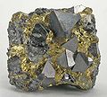
Chalcopyrite sulfide from Mount Aukas, Namibia

Vanadate Descloizit from Mount Aukas, district Grootfontein , Otjozondjupa , Namibia
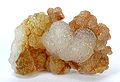
Silicate willemite from the Tsumeb Mine (Tsumcorp Mine), Namibia
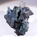
Tennantite from the Tsumeb Mine in the Oshikoto Region, Namibia


- Nosib group
The nosib sediments deposited in the Otavi Mountains contain predominantly copper - lead ores. They mineralized mainly in sandstones as well as in quartzites , epidosites, tuffs and agglomerates . In addition to copper and lead, there are also small amounts of gold , silver and vanadium . Copper and lead contents are contained in the sulfidic minerals chalcopyrite (copper pebbles), chalcosine (copper luster) and bornite (colored copper pebbles) or galena (lead luster). The sulphidic mineral pyrite (pebbles) and the lead-zinc- vanadate Descloizit are present in smaller quantities . The ore formation has a sedimentary-exhalative or volcanic-exhalative origin. The formation of the band ore horizons in the glacial diamictitic Nosib stratum can possibly also be attributed to it.
This type of deposit is called volcanically generated massive sulfidic ore deposits, or VMS type for short (English Volcanogenic massive sulfide ore deposits ). The ore formation probably took place between 750 and 635 mya and thus began with the volcanic activity during the formation of the rift valley and was concluded with the glacial diamictite deposit of the uppermost Nosib formation.
- Otavi group
In the basal subgroup above the diamictite horizon, the Otavi group contains various carbonate sequences with sulfidic and non-sulfidic non-ferrous metal deposits. The carbonate-bound lead and zinc ore deposits are called carbonate-hosted lead-zinc ore deposits or Mississippi Valley Type (MVT type). Here dominate zinc - lead - vanadium - sulphides . These non-ferrous metal deposits are designated as the Berg Aukas type after the type locality of the Berg Aukas mine in the Otjozondjupa region . The metal content in the ores is around 17% zinc (Zn), 4% lead (Pb) and up to 2.6% vanadium oxide . Geochemically they are characterized by a Zn-Pb> Cu ratio.
In the upper Otavi subgroup mainly lead-copper (Cu) -zinc sulfides occur with metal concentrations of 10% lead, 4.3% copper and 3.5% zinc. These ore deposits are named Tsumeb-type after the municipality and mining town of Tsumeb and have a geochemical ratio of Pb> Cu> Zn. Similar non-ferrous metal loading sites are also found in the upper formations of the Mulden Group, which are located on the northern edge of the Otaviberge. Above all copper with a content of 2.6% as well as silver and lead are mined here.
The sulfides in these deposits are represented by the minerals sphalerite (zinc blende), galena ( galena ), chalcopyrite (copper pyrites), pyrite (pyrites) and tennantite (arsenic pale ore). In addition, small amounts of copper and silver sulfides occur. The non-sulfidic silicon mineral willemite and the vanadium-containing Descloizite mineral are associated as secondary minerals . The mineralization and ore formation took place either in layers or in tubular or other shaped karst structures, which then form dike deposits and also boudinages . Primary deposits, mostly feldspar-containing sandstones or carbonates, were displaced by the metal-enriched solutions ( polymetallic replacement deposit ) (see also → metasomatosis and pseudomorphosis ).
The time span given is 560 to 493 mya, during which various deformation and metamorphosis processes took place in the Damara Belt and influenced the mineralization and ore formation.
Individual evidence
- ^ ZX Li, SV Bogdanova, AS Collins, A. Davidson, B. De Waele and others: Assembly, configuration, and break-up history of Rodinia: A synthesis . In: ScienceDirect, Precambrian Research, 160: 179-210, 2008. doi: 10.1016 / j.precamres.2007.04.021 , alternatively bdewaele.be PDF
- ↑ Armin Zeh, Axel Gerdes and Jackson M. Barton, Jr .: Archean Accretion and Crustal Evolution of the Kalahari Craton — the Zircon Age and Hf Isotope Record of Granitic Rocks from Barberton / Swaziland to the Francistown Arc. In: Oxford Journals, Science & Mathematics Journal of Petrology, Advance Access10.1093 / petrology / egp027, Received November 11, 2008, Accepted April 8, 2009. doi: 10.1093 / petrology / egp027 , alternatively [1]
- ↑ Pedro Oyhantçabal Siegfried Siegesmund and Klaus Wemmer: The Río de la Plata Craton: a review of units, boundaries, ages and isotopic signature. In: International Journal of Earth Sciences, April 2011, Volume 100, Issue 2, pp 201-220. doi: 10.1007 / s00531-010-0580-8 .
- ↑ Fernandez-Alonso and others: The Proterozoic History of the Proto-Congo Craton of Central Africa. In: Department of Earth Sciences, Royal Museum for Central Africa, B-3080 Tervuren, Belgium of Central Africa. africamuseum.be PDF
- ↑ David R. Gray, David A. Foster, Ben Goscombe, Cees W. Passchier and Rudolph AJ Trouw: 40Ar / 39Ar thermochronology of the Pan-African Damara Orogen, Namibia, with implications for tectonothermal and geodynamic evolution. In: Precambrian Research • October 2006. DOI: 10.1016 / j.precamres.2006.07.003 , alternatively [2] full download possible
- ↑ Hartwig E. Frimmel and Peter G. Fölling: Late Vendian Closure of the Adamastor Ocean: Timing of Tectonic Inversion and Syn-orogenic Sedimentation in the Gariep Basin. In: Gondwana Research, V. 7, No. 3, pp. 685-699, Manuscript received October 30, 2002; accepted September 12, 2003. DOI: 10.1016 / S1342-937X (05) 71056-X , alternatively [3] ; use download to read
- ↑ a b c d H. PoradaR. Wittig: Turbidites in the Damara Orogen. In: Intracontinental Fold Belts pp 543-576. [4] .
- ↑ a b c d Rudolf Nagel: One billion years of geological development on the NW edge of the Kalahari Kraton. In: Dissertation to obtain the doctoral degree of the mathematical and natural science faculties of the Georg-August University in Göttingen 1999. [5]
- ↑ R. Key and AB Kampunzu: Evolution of the Kibaran belt system in southwestern Africa: Comparison with equatorial and southern Africa. In: UNESCO-IUGS as IGCP418. Archived copy ( memento of the original from February 1, 2016 in the Internet Archive ) Info: The archive link was inserted automatically and has not yet been checked. Please check the original and archive link according to the instructions and then remove this notice.
- ↑ a b c Ilka C Kleinhanns, Thomas Fullgraf, Franziska Wilsky, Nicole Nolte and others: U-Pb zircon ages and (isotope) geochemical signatures of the Kamanjab Inlier (NW-Namibia): constraints on Paleoproterozoic crustal evolution along the southern Congo craton . In: Geological Society London Special Publications 389 (1), August 2013. DOI: 10.1144 / SP389.1 , alternatively [6]
- ^ RE Jacob, A. Kröner and AJ Burger: Areal extent and first U-Pb age of the Pre-Damaran Abbabis complex in the central Damara belt of South West Africa (Namibia). In: Geologische Rundschau, June 1978, Volume 67, Issue 2, pp 706–718. DOI: 10.1007 / BF01802813 .
- ↑ Kalahari Copper Belt - Klein Aub, Witvlei, Dordabis, Oamites. In: Website Porter GeoConsultancy. [7]
- ^ Hoffmann KH: New aspects of lithostratigraphic subdivision and correlation of late Proterozoic to early Cambrian rocks of the southern Damara Belt and their correlation with the central and northern Damara Belt and the Gariep Belt. In: Communs geol. Surv. Namibia, 5 (1989), 61-70. mme.gov.na PDF
- ↑ a b c Thomas E. Hoak, Alan L. Klawitter, Charles F. Dommer and Pasquale V. Scaturro: Integrated Exploration of the Owambo Basin, Onshore Namibia: Hydrocarbon Exploration and Implications for a Modern Frontier Basin. In: Search and Discovery Article # 10609 (2014). searchanddiscovery PDF
- ↑ Débora Barros Nascimento, A. Ribeiro, RAJ Trouw, Renata Da Silva Schmitt and Cees W. Passchier: Sequence in northwest Namibia: Slope to basin sub-marine mass-transport deposits and olistolith fields. In: Precambrian Research 278 • March 2016. doi: 10.1016 / j.precamres.2016.03.005 , alternatively [8]
- ^ PP Hoffman, DP Hawkins, CE Isachsen and SA Bowring: Precise U-Pb zircon ages for early Damaran magmatism in the Summas Mountains and Welwitschia Inlier, northern Damara belt, Namibia. In: Communs geol. Surv. Namibia, 11 (1996), 49-53. mme.gov.na PDF
- ↑ Glossary: Alkaline Rock. In: Imperial College London website, Imperial College Rock Library [9]
- ↑ a b K.-H. Hoffmann and AR Prave: A preliminary note on a revised subdivision and regional correlation of the Otavi Group 'based on glaciogenic diamictites and associated cap dolostones'. In: Communs geol. Surv. Namibia, 11 (1996), 83-88. mme.gov.na PDF
- ↑ MI Lehtonen, TET Manninen and UM Schreiber: Report: Lithostratigraphy of the area between the Swakop, Khan and lower Omaruru Rivers, Namib Desert. In: Communs geol. Surv. Namibia, 11 (1996), 71-82. mme.gov.na PDF
- ^ A b c Fred Kamona and A. Günzel: Stratigraphy and base metal mineralization in the Otavi Mountain Land, Northern Namibia- a review and regional interpretation. In: Gondwana Research 11 (3): 396-413 • April 2007. DOI: 10.1016 / j.gr.2006.04.014 , alternatively [10]
- ↑ Luke Longridge: Tectonothermal Evolution of the southwestern Central zone, Damara Belt, Namibia. In: A dissertation submitted to the Faculty of Science, University of the Witwatersrand, Johannesburg, in fulfillment of the requirements for the degree of Doctor of Philosophy. Johannesburg, 2012. core.ac PDF
- ^ R. Brand: Preliminary Report of the Stratigraphy of the Damara Sequence and the Geology and Geochemistry of Damaran Granites in an Area between Walvis Bay an Karibib. In: Communs Geol. Surv. SW Afr./Namibia, 1, 1985, 31-44. mme.gov PDF
- ^ Paul Hoffman, Joe Kirschvink, Lynn Margulis, Douglas Mawson and Mark AS McMenamin: What are Cap Carbonates? In: Snowball Earth [11]
- Jump up ↑ LE Frostick, RJ Steel, PA Kukla and IG Stainstreet: Sedimentation and Tectonics of the Khomas Hochland Accretionary Prism, along a Late Proterozoic Continental Margin, Damara Sequence, Central Namibia. In: Tectonic Controls and Signatures in Sedimentary Successions. [12]
- ^ PA Kukla, C. Opitz, IG Stanistreet and EG Charlesworth: New Aspects of the Sedimentology and Structure of the Kuiseb Formation in the western Khomas Trough, Damara Orogen, SWA / Namibia. In: Communs geol. Surv. SW Africa / Namibia, 4 (1988), 37-48. mme.gov PGF
- ↑ Cecilia AM Jönsson: Geophysical ground surveys of the Matchless Amphibolite Belt in Namibia. In: Dissertation in Geology at Lund University, Master of Science thesis no. 377, Department of Geology Lund University, 2014. [13]
- ^ A b Carsten Laukamp: Structural and Fluid System Evolution in the Otavi Mountainland (Namibia) and its Significance for the Genesis of Sulphide and Nonsulphide Mineralization. In: Inaugural - Dissertation to obtain a doctorate from the Faculty of Natural Sciences and Mathematics of the Ruprecht-Karls-Universität Heidelberg 2006. archiv.ub.uni-heidelberg PDF
- ↑ Beverly Z. Saylor, Alan J. Kaufmann, John P. Grotzinger and Frank Urban: A Composite Reference Section for Terminal Proterozioc Strata of Soutern Namibia. In: Department of Geological Sciences, Case Western Reserve University, Cleveland, Ohio 44105, USA geol. And PDF
- ↑ Uwe E. Horstmann: The metamorphic development in the Damara Orogenic, Southwest Africa / Namibia, derived from K / Ar dating on detritic light mica from molasses sediments of the Nama Group. In: Dissertation at the mathematical and natural science departments of the Georg-August-Universität Göttingen 1986. geobiologie.uni-goettingen PDF
- ^ Mine operator in Namibia. In: Website Weatherly International. [14]
- ↑ Supergenic Deposits. In: Web page Mineralienatlas - Fossil Atlas Portrait / Deposits / Supergene Enrichment Deposits
- ↑ Epidosit (epidosite). In: Website Mineralienatlas - Fossilatlas. [15]
- ↑ Mount Aukas. In: Web page Mineralienatlas - Fossilatlas. [16]