
Marange-Zondrange
| Marange-Zondrange | ||
|---|---|---|

|
|
|
| region | Grand Est | |
| Department | Moselle | |
| Arrondissement | Forbach-Boulay-Moselle | |
| Canton | Faulquemont | |
| Community association | District Urbain de Faulquemont | |
| Coordinates | 49 ° 7 ' N , 6 ° 32' E | |
| height | 239-374 m | |
| surface | 8.28 km 2 | |
| Residents | 341 (January 1, 2017) | |
| Population density | 41 inhabitants / km 2 | |
| Post Code | 57690 | |
| INSEE code | 57444 | |

Marange-Zondrange (German Möhringen-Zondringen , Lorraine Mëringen-Sonneringen ) is a French commune with 341 inhabitants (as of January 1, 2017) in the Moselle department in the Grand Est region (until 2015 Lorraine ).
geography
The community is located in a side valley of the German Nied on the road from Metz to Saint-Avold .
The hamlet of La Ferme de Henning ( Henningen ) to the north is also part of the municipality .
history
The community was formed around 1790 from the two nearby towns of Marange and Zondrange, which have belonged to France since 1766.
Marange was first mentioned in 1121 as Meringa and Mairinga . Zondrange: Zondringa (1530).
1871–1918 Marange-Zondrange belonged again to the German Empire .
Population development
| year | 1962 | 1968 | 1975 | 1982 | 1990 | 1999 | 2007 | 2015 |
| Residents | 218 | 221 | 191 | 230 | 279 | 279 | 296 | 331 |

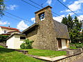
Saint Martin Church in Marange
Chapel of Saint-Sébastien in Zondrange


Web links
Individual evidence
- ↑ Mémoires de l'Académie nationale de Metz - Volume 45 (1865)