
Revel-Tourdan
| Revel-Tourdan | ||
|---|---|---|
|
||
| region | Auvergne-Rhône-Alpes | |
| Department | Isère | |
| Arrondissement | Vienne | |
| Canton | Roussillon | |
| Community association | Territoire de Beaurepaire | |
| Coordinates | 45 ° 23 ' N , 5 ° 2' E | |
| height | 267-444 m | |
| surface | 11.62 km 2 | |
| Residents | 1,053 (January 1, 2017) | |
| Population density | 91 inhabitants / km 2 | |
| Post Code | 38270 | |
| INSEE code | 38335 | |
| Website | http://www.revel-tourdan.fr/ | |

Revel-Tourdan is a French commune with 1,053 inhabitants (as of January 1 2017) in the department of Isère in the region Auvergne Rhône-Alpes ; it belongs to the arrondissement of Vienne and the canton of Roussillon (until 2015: canton of Beaurepaire ). The inhabitants are called Tourvellois .
geography
Revel-Tourdan is located about 20 kilometers southeast of Vienne on the Dolon , which borders the municipality in the north. Revel-Tourdan is surrounded by the neighboring communities Primarette in the north, Pisieu in the east, Beaurepaire in the south, Pact in the west and south-west and Moissieu-sur-Dolon in the north-west.
Population development
| year | 1962 | 1968 | 1975 | 1982 | 1990 | 1999 | 2006 | 2013 |
|---|---|---|---|---|---|---|---|---|
| Residents | 473 | 531 | 549 | 630 | 794 | 842 | 950 | 1,034 |
| Source: Cassini and INSEE | ||||||||
Attractions
- Notre-Dame priory church in Tourdan from the 12th century, monument historique since 2011
- Saint-Jean-Baptiste church from the 12th century with renovations from the 15th century
- Barbarin Castle, fortified house from the 14th century, monument historique since 2011
- Le Saut du Chevalier tower hill castle from the 11th century
- Remains of the fortress house of Barbarin from the 15th century

Saint-Jean-Baptiste church
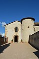
Notre-Dame priory church


Parish partnership
With the Spanish municipality of Sant Martí de Tous in Catalonia has existed since 1996.