Saint-Jean-de-Bournay
| Saint-Jean-de-Bournay | ||
|---|---|---|

|
|
|
| region | Auvergne-Rhône-Alpes | |
| Department | Isère | |
| Arrondissement | Vienne | |
| Canton | L'Isle-d'Abeau | |
| Community association | Bièvre Isère | |
| Coordinates | 45 ° 30 ' N , 5 ° 8' E | |
| height | 345-511 m | |
| surface | 26.87 km 2 | |
| Residents | 4,594 (January 1, 2017) | |
| Population density | 171 inhabitants / km 2 | |
| Post Code | 38440 | |
| INSEE code | 38399 | |
| Website | www.saintjeandebournay.fr | |
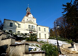
 town hall |
||
Saint-Jean-de-Bournay is a French municipality with 4594 inhabitants (as of January 1 2017) in the department of Isère in the region Auvergne Rhône-Alpes . Saint-Jean-de-Bournay is part of the Vienne arrondissement in the canton of L'Isle-d'Abeau .
geography
Saint-Jean-de-Bournay is about 20 kilometers east of Vienne . Saint-Jean-de-Bournay is surrounded by the neighboring communities of Artas in the north, Meyrieu-les-Étangs in the east, Châtonnay and Lieudieu in the southeast, Villeneuve-de-Marc in the south and southwest, Royas in the west and Charantonnay in the northwest.
The former national routes 502 , 518 and 522 run through the municipality .
history
In the 12th century the place was led as castrum sancti johannis .
| year | 1962 | 1968 | 1975 | 1982 | 1990 | 1999 | 2006 | 2011 |
|---|---|---|---|---|---|---|---|---|
| Residents | 2,887 | 3,174 | 3,240 | 3,651 | 3,764 | 3,857 | 4,188 | 4,421 |
Attractions
- Saint-Hugues de Bonnevaux church with organ, built by Joseph Merklin in 1889
- Bournay chapel from the 13th century
- town hall
- Lesdiguières tower (ruins of the former Lesdiguières castle)
- Lake Montjoux
- Forest of Bonnevaux
Personalities
- Joseph-Antoine Bouvard (1840–1920), architect
- Philippe Viannay (1917–1986), resistance fighter and journalist
Individual evidence
Web links
Commons : Saint-Jean-de-Bournay - Collection of images, videos and audio files
