
Wolfgang (pass)
| wolfgang | |||
|---|---|---|---|
 Transition from the south |
|||
| Compass direction | north | south | |
| Pass height | 1631 m above sea level M. | ||
| Grisons | Canton | ||
| Valley locations | Monastery | Davos | |
| expansion | Pass road / Rhaetian Railway | ||
| profile | |||
| Ø pitch | 6.8% (452 m / 6.65 km) | 2.1% (70 m / 3.35 km) | |
| Max. Incline | 10% | ||
| Map (Graubünden) | |||
|
|||
| Coordinates | 784 217 / 189714 | ||

As Wolfgang (also called Wolfgangpass ) is a 1631 m above sea level. M. high mountain crossing in the Swiss canton of Graubünden , which crosses the location with the same name at the culmination point. The pass connects Klosters in the Prättigau with Davos in the Landwassertal .
geography
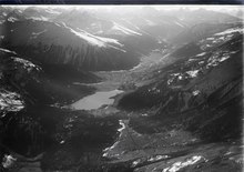
The top of the pass is in the area of the Davos landscape. At the culmination above the flat south ramp (70 meters in altitude) lies the Davos-Wolfgang settlement (neighborhood) belonging to the former Davos-Dorf parliamentary community , further south of the Davosersee .
The pass was created by a landslide from the Totalp in the Parsenn area in prehistoric times, which at least blocked the Flüelabach , which until then flowed towards Klosters.
Surname
The name of the place and the transition is Wolfgang on the national map of Switzerland and other official and scientific bodies. The name Wolfgang Pass can be found in travel literature and on Google Earth , for example .
Transport and tourism
Over the pass the winter safely leads the main road 28 and in 1890 was put into operation railway line Landquart-Davos Platz of the Rhaetian Railway . The height information refers roughly to the natural saddle in front of the Hotel Kulm, which existed before the construction of the railway line, while today's road rises a little higher to cross the railway.
The trade route that led through the Davos countryside during the times of the trading days is even older ; it can be followed as the cultural-historical long-distance hiking trail Via Valtellina from Montafon to Italy and leads from the north over the Wolfgang on the second day.
Web links
- The gradient of the pass from Klosters to the top of the pass
- Martin Bundi: Wolfgang. In: Historical Lexicon of Switzerland .
credentials
- ↑ Directory of field names
- ↑ Inventory of historical traffic routes: Designation as Wolfgang ( Memento from January 12, 2016 in the Internet Archive ) (PDF; 435 kB)
- ↑ Graubünden civil engineering office: roads and passes
- ^ Rudolf and Marga Graubner: The Great Alpine Guide in Color, Eastern Alps . Weltbild, Augsburg 1979
- ^ Author collective: The great ADAC Alpine Guide . ADAC Verlag GmbH Munich 1992, ISBN 3-87003-470-X
- ↑ Swiss cultural and historical hiking trail Via Valtellina over the Wolfgang ( Memento from January 12, 2016 in the Internet Archive )
Ächerli • Agites • Aiguillon • Albis • Albula • Balmberg • Benkerjoch • Bernina • Böhler • Bözberg • Breitehöchi • Brünig • Buechenegg • Bürersteig • Chall • Challhöchi Pass • Champex • Chasseral • Chatzenstrick • Chilchzimmersattel • Croix • Croix • Croix de Coeur • Eichhöhe • Étroits • Etzelpass • Flüela • Forclaz • Furka • Ghöch • Givrine • glass • Glaubenberg • Glaubenbielen • Gottschalkenberg • Grimsel • Grosse Scheidegg • Gr.St.Bernhard • Gurnigel • Haggenegg • Hahnenmoos • Heitersberg • Hilferen • Hirzel • Hirzel Höhi • Hulftegg • Ibergeregg • Jaman • Jaun • Julier • Kerenzerberg • Klausen • Kunkels • Lein • Lenzerheide • Livigno • Lukmanier • Maloja • Marchairuz • Mollendruz • Mont Crosin • Monte Ceneri • Mont d'Orzeires • Montvoie • Morgins • Mosses • Mutschellen • Neggia • Nufenen • Oberalp • upper Hauenstein • Oberricken • oven • Orn • Passwang • Pierre Pertuis • Pillon • Planches • Pontins • Pragel • edge crossing • Rangiers • rates • Rengg • crocheted • Roches • 'groups • R üsler • Saanenmöser • Salhöhe • San Bernardino • Sanetsch • Santelhöchi • Sattel • Sattelegg • Schafmatt • Schallenberg • Schelten • Schönau • Schufelberger Egg • Schwägalp • Schwarzenbühl • Siblingerhöhe • Simplon • Splügen • St. Anton • St. Gotthard • St. Luzisteig • Staffelegg • Stoss • Susten • Tourne • Tronc • Umbrail • Unterer Hauenstein • Front Höhi • Vue des Alpes • Wasserfluh • Weissenstein • Wildhaus • Wissegg • Wolfgang