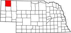
Dawes County
![The Dawes County Courthouse in Chadron, listed on the NRHP since 1990 [1]](https://upload.wikimedia.org/wikipedia/commons/thumb/8/8a/Dawes_County%2C_Nebraska_courthouse_from_E.JPG/298px-Dawes_County%2C_Nebraska_courthouse_from_E.JPG) The Dawes County Courthouse in Chadron, listed on the NRHP since 1990 |
|
| administration | |
|---|---|
| US state : | Nebraska |
| Administrative headquarters : | Chadron |
| Address of the administrative headquarters: |
County Courthouse 451 Main Street Chadron, NE 69337-2697 |
| Foundation : | 1885 |
| Area code : | 001 308 |
| Demographics | |
| Residents : | 9182 (2010) |
| Population density : | 2.5 inhabitants / km 2 |
| geography | |
| Total area : | 3628 km² |
| Water surface : | 12 km² |
| map | |
| Website : www.co.dawes.ne.us | |
The Dawes County is a county in the US state of Nebraska . The county seat is Chadron , named after Louis Chadron , an early trapper in the area.
geography
The county is located almost in the extreme northwest of Nebraska, borders South Dakota to the north , is about 40 kilometers from Wyoming to the west and has an area of 3,628 square kilometers, of which 12 square kilometers are water. It borders on the following counties:
|
Fall River County, South Dakota |
Oglala Lakota County, South Dakota |
|
| Sioux County |

|
Sheridan County |
| Box Butte County |
history
Dawes County was formed from part of Sioux County in 1885. It was named after James W. Dawes (1844-1918), the fifth governor of Nebraska (1883-1887).
One location has National Historic Landmark status , Fort Robinson and Red Cloud Agency . A total of 15 buildings and sites in the county are registered on the National Register of Historic Places (as of February 10, 2018).
Demographic data
| growth of population | |||
|---|---|---|---|
| Census | Residents | ± in% | |
| 1890 | 9722 | - | |
| 1900 | 6215 | -36.1% | |
| 1910 | 8254 | 32.8% | |
| 1920 | 10.160 | 23.1% | |
| 1930 | 11,493 | 13.1% | |
| 1940 | 10.128 | -11.9% | |
| 1950 | 9708 | -4.1% | |
| 1960 | 9536 | -1.8% | |
| 1970 | 9761 | 2.4% | |
| 1980 | 9609 | -1.6% | |
| 1990 | 9021 | -6.1% | |
| 2000 | 9060 | 0.4% | |
| 2010 | 9182 | 1.3% | |
| Before 1900 1900–1990
2000 + 2010 |
|||
According to the 2010 census , Dawes County had 9,182 people in 3,223 households. The population density was 2.5 inhabitants per square kilometer. Statistically, there were 2.42 people each in the 3,223 households.
The racial the population was composed of 89.4 percent white, 1.5 percent African American, 3.9 percent Native American, 1.0 percent Asian and other ethnic groups; 2.5 percent were descended from two or more races. Hispanic or Latino of any race was 3.3 percent of the population.
19.4 percent of the population were under 18 years old, 64.9 percent were between 18 and 64 and 15.7 percent were 65 years or older. 51.4 percent of the population was female.
The median income for a household was 35,165 USD . The per capita income was $ 16,987. 20.4 percent of the population lived below the poverty line.
Places in the county
Individual evidence
- ↑ Extract from the National Register of Historic Places - No. 90000975.Retrieved September 19, 2011
- ↑ GNIS-ID: 835844. Retrieved on February 22, 2011 (English).
- ↑ Listing of National Historic Landmarks by State: Nebraska . National Park Service , accessed February 10, 2018.
- ↑ Search mask database in the National Register Information System. National Park Service , accessed February 10, 2018.
- ^ US Census Bureau _ Census of Population and Housing.Retrieved February 17, 2011
- ↑ Extract from Census.gov.Retrieved February 17, 2011
- ↑ Excerpt from census.gov (2000 + 2010) ( Memento from July 9, 2011 on WebCite ) Retrieved April 13, 2012
- ^ US Census Bureau, State & County QuickFacts - Dawes County ( July 9, 2011 memento on WebCite ) Retrieved September 19, 2011
Web links
Coordinates: 42 ° 43 ′ N , 103 ° 8 ′ W

