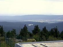
High Fichtel Mountains
| High Fichtel Mountains | |
|---|---|
|
Horseshoes of the Hohe Fichtelgebirge |
|
|
Map with traffic routes |
|
| Highest peak | Schneeberg ( 1051 m above sea level ) |
| location | Bavaria , Czech Republic |
| part of | Thuringian-Franconian low mountain range |
| Classification according to | Handbook of the natural spatial structure of Germany |
| Coordinates | 50 ° 3 ' N , 11 ° 51' E |
| surface | 752.0 km² |
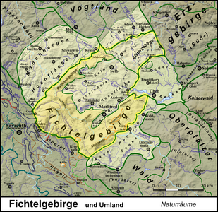
The High Fichtelgebirge is a forest and mountain rich, from a plurality of mountain ranges composite massif which horseshoe-shaped (horseshoe-Fichtelgebirgshalle) the Selb-Wunsiedler high surface encloses. In terms of natural space , the Hohe Fichtelgebirge represents the main unit 394 within the main unit group Thuringian-Franconian low mountain range (39), which stretches from the Thuringian Forest to the Fichtelgebirge .
geography
The north-west of the horseshoe is occupied by the ridge of the Waldsteingebirge , which ends in the south-west at Gefrees- Kornbach, with the Großer Waldstein (877 m) in the center and the Kornberg massif with the Großer Kornberg (827 m) in the northeast.
The south-west is taken up by the south-east facing Hohe Fichtelgebirge with the massifs of Schneeberg (up to 1051 m), Ochsenkopf (up to 1024 m) and Kosseine (up to 939 m).
The south-west is formed by three heaths: On the Hohe Heide mountain (848 m) in the north-west of the Schneeberg massif, the Riedel of the same name branches off to the south-west , which gradually flattens to the Mainberg (623 m) and is bordered to the south-east by the White Main . To the east of the Weißmain and southwest of the Ochsenkopf lies the Königsheide (up to 863 m), to the east of it and separated by the Warm Steinach is the Nasse Heide (Kreuzstein group) (up to 838 m).
Separated from the Nassen Heide by the Fichtelnaab near Neusorg , the northeast facing southeast of the Horseshoe joins with stone forest (up to 946 m), Reichsforst (up to 705 m) and cabbage forest (up to 656 m).
Natural structure
Draft of a natural spatial structure in the north-east Bavarian region
Since September 2010 there has been a new design for the natural areas of northeast Bavaria, in which the Hohes Fichtelgebirge natural area only refers to the central part of the mountain and the horseshoe is structured as follows: In the letter code of a natural area, a prefixed "W" stands for Hercynian W aldgebirge (= Thuringian-Franconian Mittelgebirge + Vogtland ) and the following "f" each for F ichtelgebirge , which is then followed by an abbreviation letter for each natural area:
- ( Hohes Fichtelgebirge in the broader sense ≈ main unit 394 according to the manual of the natural spatial structure of Germany )
- Wfb Bernecker area - on both sides of the Weißmain at its southernmost point near Bad Berneck -Escherlich
- Wfw Waldsteinzug - Waldstein Mountains , northeast of Gefrees -Kornbach
- Wfh Hohes Fichtelgebirge (in the narrower sense) - ridge area in the southwest with Schneeberg, Ochsenkopf, Kosseine as well as Königsheide and Kreuzstein group
- Wfe Erbendorfer Talzug - area on the Fichtelnaab between Neusorg and Erbendorf ; with Armesberg
- Wfs Steinwald - Steinwald, but without the basalt northeast
- Wfp Pechbrunner Basaltgebiet (with Reichsforst) - Reichsforst including northeastern stone forest ( Großer Teichelberg )
- Wfk Kohlwaldgebiet - Kohlwald (in the broader sense), extended to the east to Waldsassen .
The structure described here draws the boundaries between the parts of the Hohe Fichtelgebirge (in a broader sense) and Innerer Plateau ( Wfi, "Inneres Fichtelgebirge" ) somewhat differently than the former Federal Institute for Regional Studies. In particular, there are the places on the upper Fichtelnaab (upstream: Ebnath , Brand , Mehlmeisel and Fichtelberg ) in the Inner Fichtel Mountains.
Also the border of the Fichtelgebirge to the Naab-Wondreb-Senke is shifted a little to the southeast, whereby z. B. Erbendorf and Waldsassen hike from the valley into the Fichtelgebirge - according to this structure , the Naab-Wondreb valley has neither a connection to the northeast to the Eger basin nor to the southwest to the Upper Palatinate hill country and is regarded as part of the Upper Palatinate Forest .
This structure is therefore only partially compatible with the older, established basic structure.
Natural subdivision according to the LfU Bavaria
Deviating from the above structure, the Bavarian State Office for the Environment has made a subdivision of the High Fichtelgebirge, which is fully compatible with the main units of the Federal Institute for Regional Studies and subdivides the horseshoe as follows:
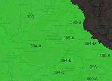
- 394 Hohes Fichtelgebirge (452.0 km²)
- 394-A west and north ridge of the Hohe Fichtelgebirge (463.2 km²)
- 394-B Pilgramsreuther Sattel (56.9 km²)
- 394-C Steinwald (LfU) (158.7 km²)
- 394-D Lausnitzer Randberge (73.2 km²)
Unit 394-A includes the Waldstein range and the “Kern” -Fichtelgebirge ( Hohes Fichtelgebirge in the narrower sense ) as well as the small Bernecker area. It ends to the southeast in front of or, in a few places, on the Marktredwitz - Kulmain ( Nuremberg - Cheb ) railway line , which is largely followed by the St 2177 state road .
The southwest part of the depression leading the railway and the state road is counted from (Kulmain-) Oberwappenöst via (Neusorg-) Wernersreuth , (Pullenreuth-) Lochau as well as Neusorg and Pullenreuth up to the eponymous (Pullenreuth-) Pilgramsreuth to the unit 394-B, the Northeast part with Waldershof and Marktredwitz already to the Selb-Wunsiedeler plateau (395). The Pilgramsreuther Sattel stretches east of it over (Waldershof-) Poppenreuth to around (Marktredwitz-) Manzenberg and occupies the western slopes of the Steinwald and the Reichsforst, which are no longer completely forested.
The stone forest according to this classification (394-C) includes not only the stone forest in the narrower sense, but also the areas to the right (southwest) of the Fichtelnaab with the Armesberg and practically the entire Reichsforst .
The unit 394-D finally contains mainly the carbon forest with Arzberger Forest ( carbon forest in the strict sense ) and the subsequent southeast Munich Reuther Wald , together with clearings around the eingemeindeten to Waldsassen places Münchenreuth and Pechtnersreuth and the adjoining south, largely treeless Area around Konnersreuth .
Geomorphological classification of the Czech Republic
In the geomorphological breakdown of the neighboring Czech Republic , Ašská vrchovina (German: Ascher Bergland), Hazlovská pahorkatina (German: Haslauer Hügelland) and Chebská pahorkatina (German: Egerer Hügelland) are assigned to the (High) Fichtel Mountains as the main unit Smrčiny (I3A-1).
Watersheds and main ridge lines
Of the many rivers and streams that arise in the Fichtel Mountains, only three in the main leave it:
- The Eger drains most of the inner plateau and leaves the low mountain range on the German side near Hohenberg an der Eger , in the northeast. It drains over the Elbe to the North Sea.
- The Fichtelnaab drains the southeast to the Naab and thus to the Danube and the Black Sea.
- The White Main drains the extreme west to the Main and thus over the Rhine to the North Sea.
In contrast, the rivers that drain over the Saale to the Elbe in the north-west play only a minor role : the Lamitz and the Perlenbach . Nevertheless, these are the only rivers that break through the horseshoe of the Fichtelgebirge and accordingly have an impact on the altitude structure. In particular, they move the watersheds into the interior of the Fichtelgebirge.
European main watershed
The European main watershed between the North Sea and the Mediterranean runs through the south of the Fichtelgebirge Horseshoe. As a watershed between Main and Naab, it comes from the southwest via the following line:
- ( Kirchenpingarten -) Muckenreuth (at approx. 574 m )
- Muckenreuther Rangen (836 m)
- Kreuzstein ( 838 m )
-
Hüttenberg (Kreuzstein group) ( 758 m )
- ↓ Scharte at the Hüttener Sattel southeast ( Warmensteinach -) Hüttens (at approx. 726 m )
- Ochsenkopf ( 1024 m )
- Lake hill ( 953 m )
With the construction of the Bocksgraben in 1795, the watershed between Ochsenkopf and Hüttener Sattel was moved to Osdten.
The European main watershed leaves the Fichtelgebirge as a watershed between Eger and Waldnaab in the Steinwald , from the Kleiner Teichelberg ( 708 m ) southeast to the Torberg ( 561 m ) northeast of Fuchsmühl .
The larger part of the European main watershed, lying between the two sections, is also part of the main watershed of the Fichtelgebirge Horseshoe .
Obereger watershed
The actual main watershed of the Fichtelgebirge is that of the upper Eger up to the union with the Wondreb . She follows, e.g. T. alternating between the ridge lines, the horseshoe shape. From the north of the Fichtelgebirge it takes the following course, counterclockwise ( only the most important of the notches are listed):
- Czech-German border (at approx. 640 m )
- Rabenberg ( 719 m )
-
Great Kornberg ( 827 m )
- ↓ Scharte near Niederlamitz (at approx. 565 m )
-
Bergkopf ( 857 m )
- ↓ Scharte on the road Weißenstadt - Sparneck (at approx. 762 m )
- Great Waldstein ( 877 m )
- High Heide ( 848 m )
- Schneeberg ( 1051 m )
- Nusshardt ( 972 m )
- Lake hill ( 953 m )
-
Plate ( 883 m )
- ↓ Scharte west of the Silberhaus (at approx. 720 m )
-
Hohe Matze ( 813 m )
- ↓ Scharte northeast of Wurmloh (at approx. 655 m )
- Kosseine ( 939 m )
-
Heuberg ( 697 m )
- ↓ Scharte on the Pilgramsreuther Sattel (at approx. 606 m )
- Harlachberg ( 686 m )
- Knock ( 845 m )
- Plate ( 946 m )
- Plößberg ( 946 m )
- Herzogöd Hill ( 751 m )
- Kleiner Teichelberg ( 708 m )
- Roßkopf ( 725 m )
- Wappenstein ( 672 m )
- Steinberg ( 705 m )
- Cairn ( 677 m )
- Ruhberg ( 693 m )
-
Preisberg ( 635 m )
- ↓ Scharte northeast of Preisdorf (at approx. 568 m )
- Lehenbuehl ( 622 m )
- Dietzenberg ( 626 m )
- Výhledy ( 655.8 m )
The deepest notch is the one in the Inner Fichtel Mountains to the east of the Waldstein range between Grosses Waldstein and Grosser Kornberg; interrupted here only by the narrow Lamitz valley, while the main traffic axis runs into the Fichtelgebirge at the Pilgramsreuther Sattel between Kosseine and Steinwald. The Pechbrunner Sattel between Steinwald and Reichsforst is also used by the motorway and railroad; however, beyond this the heights only rise by a maximum of approx. 120 m.
Deviation of the main ridge line from the watershed
Only north of Schönwald , northwest of Kirchenlamitz and between Reichsforst and Kohlwald does the watershed described above deviate from the main ridge direction:
The Waldsteinkamm in the extreme northwest of the horseshoe, including the two valleys, has the following course towards the southwest:
-
Schönlinder Höhe ( 682 m )
- ↓ Perlenbach (at approx. 559 m )
- Pfaffenberg ( 710 m )
- Rabenberg ( 719 m )
-
Great Kornberg ( 827 m )
- ↓ Lamitz (at approx. 547 m )
- Little Kornberg ( 678 m )
- (various lesser known peaks)
- Bergkopf ( 857 m )
- Great Waldstein ( 877 m )
The ridge course between Reichsforst and Kohlwald, including the Feisnitz Valley, is the following:
- Ruhberg ( 693 m )
-
Elmberg ( 618 m )
- ↓ Feisnitz (at approx. 505 m )
- Kohlberg ( 633 m )
- Siebenlindenberg ( 643 m )
- Moosrangen ( 599 m )
geology
Geologically , the mountain range consists essentially of granite . The history of its orogeny begins in the Precambrian about 750–800 million years ago - the mountains cover almost 20% of the earth's history , which only applies to a few of the rump mountains that still exist today .
mountains
The mountains in the Hohe Fichtelgebirge include, sorted by height in meters (m) above sea level (NN):
| mountain | Height (m) | annotation |
|---|---|---|
| Schneeberg | 1,051 | Highest mountain in the Fichtelgebirge, Haberstein ( 923 m ) on the southwest slope |
| Ox head | 1,024 | Winter sports, chair lifts and drag lifts, Weißmainfelsen ( 906 m ) on the eastern slope |
| Nusshardt | 972 | Adjoining Schneeberg to the southeast |
| Sea hill | 953 | Adjoining Nusshardt to the south-east; Ahornfels ( 910 m ) on the southwest slope |
| Slab (stone forest) | 946 | Highest elevation of the stone forest , with 35 m high Upper Palatinate Tower, viewing platform at 976 m total height |
| Kitchenette | 939 | Small Kosseine ( 922 m ) secondary peak |
| Platte (Schneeberg) | 885 | Adjacent to the sea hill to the south-east |
| Burgstein (Kössein massif) | 879 | Burgsteinfelsen at 869.2 m, Luisenburg-Kreuzfelsen ( 785 m ) at the north foot |
| Great Waldstein | 877 | Winter sports, trails |
| Rudolfstein (Schneeberg) | 866 | Rock formation at the summit and formation Drei Brüder ( 850 m ) 500 m southwest |
| Hohberg | 863 | Highest elevation of the Königsheide ; Winter sports, drag lifts |
| Weißenstein (Steinwald) | 863 | |
| Bergkopf (Waldstein) | 857 | 25 m high ( 817 m above sea level ) granite formation Hoher Stein at the northeast foot |
| Haberstein (Köseine) | 848 | |
| Cross stone | 838 | Highest elevation of the Kreuzstein group between Warmer Steinach and Fichtelnaab |
| Klausenberg | 835 | 2.5 km southeast of the Kreuzstein; Doppelkuppe (south summit: Holzgrabenberg ); Klausenturm on the northeast flank at approx. 820 m |
| Plate (group of cross stones) | 830 | Southwest of the Kreuzstein group, 2.5 km east-northeast of Kirchenpingarten -Muckenreuth |
| Great Kornberg | 827 | Winter sports, drag lift and trails |
| High matzo | 813 | Prinzenfelsen rock formation ( 751 m ) |
| Epprechtstein (Waldstein) | 798 | Winter sports, trails |
| Lehstenberg | 768 | |
| Schauerberg (Kössein massif) | 767 | |
| Schauerberg (Schneeberg massif) | 732 | |
| Armesberg | 731 | Erbendorfer Talzug , on the right the Fichtelnaab; Basalt rim mountain |
| Rabenberg | 719 | Northern Kornberg massif |
| Tannenberg | 711 | South-southeastern edge of the Kreuzstein group; 1 km northeast of Immenreuth -Ahornberg |
| Pfaffenberg (Schönwald) | 710 | |
| Little Teichelberg | 708 | |
| Steinberg (Reichsforst) | 705 | |
| Calm mountain | 692 | Summit region nature reserve |
| Berg (Weißenstadt) | 691 | |
| Wenderner stone | 686 | |
| Great Teichelberg | 685 | |
| Fürstenstein | 675 | |
| Výhledy (German: Oberkunreuthberg ) | 656 | Well house |
| Sieben-Linden-Berg | 643 | Winter sports, trails |
| Zelená hora (German: Grünberg ) | 637 | Telecommunication tower, observation tower Bismarck tower |
| Kohlberg (Kohlwald) | 633 | Waldenfelswarte observation tower |
| Glasberg | 628 | Holy Trinity Church Kappl |
| Dietzenberg | 626 | |
| Mainberg | 623 | Berneck area , western edge of the Fichtelgebirge, 3 km east of Bad Berneck |
| Lehenbuehl | 620 | at Konnersreuth |
| Elmberg | 618 | |
| Gossenbühl | 616 | |
| Konnsberg | 613 | at Konnersreuth |
Localities
Bavaria
Czech Republic
|
|
|
|
Waters
- See Fichtelgebirge
traffic
- Marktredwitz railway junction
- Federal roads 303 and 15
- Federal motorways 93 and 9
Buildings
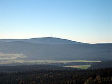
In addition to numerous observation towers and platforms, the most conspicuous structures in the Hohe Fichtelgebirge are the former military use and now decommissioned telecommunications towers on the Schneeberg (tower height 73 m) and the Großer Kornberg (tower height 64 m), as well as the civilly used telecommunications towers on the Ochsenkopf (tower height 163 m) and the Zelená hora (German: Grünberg) in the Czech part of the mountains .
Individual evidence
- ↑ a b c d e f The Fichtel Mountains in the Bavaria Atlas of the Bavarian State Government : main ridge line, watersheds, natural areas and main mountains ( notes )
- ↑ BfN indicates an area of 742 km², see profile. The deviation of around 1.3% is within the tolerance range, especially since the boundaries between BfN and LfU differ slightly from one another. BfN in particular does not claim to be particularly precise either - a corresponding warning is given in the relevant map service if you come into the area of the TK 50. Both are mainly based on the 1: 1,000,000 map of the manual, the rough scale of which alone does not allow high levels of accuracy for area information.
- ^ E. Meynen and J. Schmithüsen : Handbook of the natural spatial structure of Germany - Federal Institute for Regional Studies, Remagen / Bad Godesberg 1953–1962 (9 deliveries in 8 books, updated map 1: 1,000,000 with main units 1960)
- ↑ Map services of the Federal Agency for Nature Conservation ( information )
- ^ Karl Heinrich Vollrath: Viola in Northeast Bavaria (page 132-133)
- ^ Regional structure of Bavaria by the LfU
- ↑ a b Within the boundaries of the LfU, the Steinwald has an area of 153.8 km² and the Pilgramsreuther Sattel an area of 61.8 km². However, according to this demarcation, the Pilgramsreuther Sattel goes as far as the main ridge of the Steinwald near Herzogös (summit directly on the hamlet: 751 m) and even crossed the 770 m line northwest of the Plößberg. Since all other natural boundaries, even those from 394-A to 395-A north of the Schneeberg, remain below 700 m, it can only be a mistake. If you extend the border line northeast of the 725 m high mountain peak to the west of the 707 m high Kleiner Teichelberg by the 690 m height line, the stone forest area increases by about 4.9 km² and that of the Pilgramsreuther saddle decreases accordingly.
- ↑ Smrčiny (Fichtel Mountains)
- ↑ The Bocksgraben on bayern-fichtelgebirge.de
cards
- Fritsch hiking map 1: 50.000 Fichtelgebirge-Steinwald, ISBN 978-3-86116-052-6
Web links
- Landscape profile Hohes Fichtelgebirge of the Federal Agency for Nature Conservation ( information )
- The Fichtel Mountains in Bavaria Atlas of the Bavarian State Government : main ridge line, watersheds, natural areas and main mountains ( notes )
