
Guebwiller
| Guebwiller | ||
|---|---|---|
.svg)
|
|
|
| region | Grand Est | |
| Department | Haut-Rhin | |
| Arrondissement | Thann-Guebwiller | |
| Canton | Guebwiller (main town) | |
| Community association | Region of Guebwiller | |
| Coordinates | 47 ° 54 ' N , 7 ° 13' E | |
| height | 254-620 m | |
| surface | 9.68 km 2 | |
| Residents | 11,094 (January 1, 2017) | |
| Population density | 1,146 inhabitants / km 2 | |
| Post Code | 68500 | |
| INSEE code | 68112 | |
| Website | www.ville-guebwiller.fr | |
 View of Guebwiller |
||

Guebwiller ( German Gebweiler , Alsatian : Gawill'r ) is a French town with 11,094 inhabitants (as of January 1, 2017) in the Haut-Rhin department in the Grand Est region (until 2015 Alsace ). Until December 31, 2014, the city was the seat of the sub-prefecture (French sous-préfecture ) of the Arrondissement of Guebwiller . It is the capital (French: chef-lieu ) of the canton of Guebwiller and the seat and member of the communal association Communauté de communes de la Région de Guebwiller .
geography
Guebwiller is located at the outlet of the river Lauch from the Vosges into the Upper Rhine Plain at 268 m above sea level. NHN. The municipality of Guebwiller is part of the Ballons des Vosges Regional Nature Park .
The Guebwiller station was on the Bollwiller – Lautenbach line .
geology
In the surrounding area, in the Gebweiler valley, there are rocks.
history
Guebwiller was mentioned for the first time as Gebunvillare in 774 in a deed of donation in which the Murbach Monastery is honored. At that time it was just an estate. The town developed into a town in the 12th century around the church of Saint-Léger and a castle complex, which is now called the Burgstall . A city wall was built between 1270 and 1287. In 1394 there were 1350 inhabitants.
During the Thirty Years War the city was sacked by Sweden. At the end of this war, the city became part of France on the basis of the Peace of Westphalia . In 1657 only 176 people lived in the city.
In the course of the 19th century a significant textile industry with special working-class quarters emerged. After Mulhouse, the city was their largest location; wool and cotton were processed. Around 1900 the city had one Protestant and two Catholic churches, a synagogue , a grammar school , a district court and a forest ranger's office .
Demographics
| Number of residents according to the year | ||||||||||||||||
|---|---|---|---|---|---|---|---|---|---|---|---|---|---|---|---|---|
| year | 1793 | 1856 | 1861 | 1872 | 1890 | 1900 | 1905 | 1910 | 1962 | 1968 | 1975 | 1982 | 1990 | 1999 | 2006 | 2017 |
| Residents | 3,005 | 8,971 | 10,680 | 12,218 | 12,367 | 13,254 | 13,313 | 13,024 | 10,568 | 10,840 | 11,072 | 10,689 | 10,942 | 11,525 | 11,609 | 11.094 |
Viticulture
The municipality of Guebwiller is one of the most important vineyards in Alsace. The Alsace Grand Cru appellation, created in 1975, has been defining prominent individual sites in the Alsace wine-growing region since 2007 . The 51 locations are spread across 47 communities. Guebwiller is the only municipality to have four of these grand cru locations:

- Kessler (28.53 ha)
- Kitterlé (25.79 ha)
- Saering (26.75 ha)
- Spiegel (18.26 ha, partly in Bergholtz area)
Attractions
- The late Romanesque church with Gothic choir Saint-Léger (St. Leodegar ) was built from 1182 to 1287 and after 1336 the choir area was redesigned in Gothic style.
- The Dominican monastery with mendicant Gothic style contains medieval frescoes on the side walls. Today the church is used as a concert hall.
- The Notre-Dame church (1760–1785) designed by the architect Louis Beuque from Besançon is the largest classicist church building in Alsace. It is richly decorated (pulpit, altars, confessionals, " Assumption of Mary " on the altar wall) by Fidel Sporer , with the help of his daughter Helene ( wood carver ). The church was built by the sculptor and builder Gabriel Ignaz Ritter (1732–1813) from Andelsbuch and contains an important organ ( Charles Mutin , 1908) in an original housing from 1785.
- Synagogue , built from 1869 to 1872 ( Monument historique )
- The town hall in the late Gothic flamboyant style dates from 1514.
- The Musée Théodore Deck et des pays du Florival is the largest museum in Upper Alsace outside Colmar and Mülhausen .
- In Guebwiller there is a Franco-German military cemetery where over 1000 German and nearly 450 French war dead from World War I and 175 German war dead from World War II are buried. It was created by the German side in 1914 after the first battles in this area. The final design was completed in 1977.
- The menhirs of the Appenthal stone line (Alignements d'Appenthal) are north-west of Guebwiller.
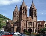
Romanesque church of Saint-Léger

Notre-Dame classical church

Interior view of Notre-Dame

Notre-Dame-du-Saering chapel
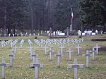
Franco-German military cemetery


Up the valley lies the ruins of the former Hugstein Castle (13th century) on a hill on the road to Murbach . On the ridge of the Oberlinger , which rises north of the city, there are small remains of a large medieval castle complex. Eight kilometers to the west is the Great Belchen , the highest mountain in the Vosges at 1,424 m .
Personalities

- François Joseph Rudler (1757–1837), lawyer, notary and reformer
- Benedikt Anton Friedrich von Andlau-Homburg (1761–1839), Prince and Abbot of Geiville (= Gebweiler / Guebwiller)
- Margarethe Stockhausen (1803–1877), singer
- Xaveria Rudler (1811–1886), French-German religious
- Niklaus Riggenbach (1817–1899), inventor of the Riggenbach cog railway system and the steam locomotive's counter pressure brake
- Jean-Baptiste Weckerlin (1821–1910), French composer
- Théodore Deck (1823–1891), ceramist of historicism and Art Nouveau
- Christian Schussele (1824–1879), painter
- Gustave Schlumberger (1844–1929), French historian
- Charles-Daniel Bourcart (1860–1940), Swiss diplomat
- Andreas Bauer (1866–1900), German Catholic monk, missionary and martyr
- Jeanne Bucher (1872–1946), French art dealer and founder of the Paris gallery Jeanne Bucher
- Alice von Mülinen (1868–1952), poet
- Jean Schlumberger (1877–1968), Germanist and writer
- Conrad Schlumberger (1878–1936), geophysicist and geologist
- Charles Hueber (1883–1943), politician, member of parliament and mayor of Strasbourg
- Günther Stapenhorst (1883–1976), German film producer
- Marcel Schlumberger (1884–1953), engineer
- Alfred Kastler (1902–1984), physicist and Nobel Prize winner (1966)
- Henri Madelin SJ (1936–2020), Jesuit and university professor
- Katia Krafft (1942–1991), volcanologist
Town twinning
Guebwiller has twinned cities with the Italian municipality of Castelfiorentino in Tuscany and, for historical reasons, with Lucerne .
literature
- Le Patrimoine des Communes du Haut-Rhin. Flohic Editions, Volume 1, Paris 1998, ISBN 2-84234-036-1 , pp. 476-500.
- Gebweiler , in: Théodore François Xavier Hunkler, History of the City of Colmar and the Surrounding Area , Colmar 1838, pp. 452–455 ( online ).
Web links
Individual evidence
- ↑ Gebhard: Geologische Mittheilungen from the Gebweiler Thal , Volume 2, Colmar 1877 ( E-Copy ).
- ↑ a b Meyer's Large Conversation Lexicon . 6th edition, Volume 7, Leipzig / Vienna 1907, p. 423 ( Zeno.org )
- ↑ a b c d M. Rademacher: German administrative history from the unification of the empire in 1871 to the reunification in 1990. (Online material for the dissertation, Osnabrück 2006)
- ^ Complete geographic-topographical-statistical local lexicon of Alsace-Lorraine. Contains: the cities, towns, villages, castles, communities, hamlets, mines and steel works, farms, mills, ruins, mineral springs, etc. with details of the geographical location, factory, industrial and other commercial activity, the post, railway u. Telegraph stations and the like historical notes etc. Adapted from official sources by H. Rudolph. Louis Zander, Leipzig 1872, Sp. 18 ( online )
- ↑ Official homepage ( Memento of the original from January 15, 2011 in the Internet Archive ) Info: The archive link was inserted automatically and has not yet been checked. Please check the original and archive link according to the instructions and then remove this notice.