Parzanica
| Parzanica | ||
|---|---|---|

|
|
|
| Country | Italy | |
| region | Lombardy | |
| province | Bergamo (BG) | |
| Local name | Parsànega | |
| Coordinates | 45 ° 44 ' N , 10 ° 2' E | |
| height | 753 m slm | |
| surface | 10.8 km² | |
| Residents | 357 (Dec. 31, 2019) | |
| Population density | 33 inhabitants / km² | |
| Post Code | 24060 | |
| prefix | 035 | |
| ISTAT number | 016159 | |
| Popular name | Parzanicensi | |
| Patron saint | San Colombano | |
| Website | Parzanica | |

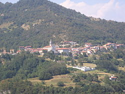
View over the town to Lake Iseo
Parzanica is a northern Italian municipality ( comune ) with 357 inhabitants (as of December 31, 2019) in the province of Bergamo in Lombardy .
The municipality is located on the western shore of Lake Iseo on Strada Statale 469. Parzanica borders the municipalities of Marone and Monte Isola in the province of Brescia .
Attractions
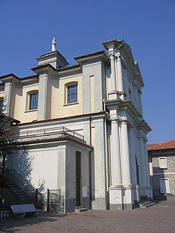
- The parish church of San Colombano, dedicated to St. Columban of Luxeuil , dates from the late 16th century. It stands on the southern edge of the village. The church tower has a carillon of five bells.
- In the Acquaiolo district a little below, on the road to Cambianica, there are beautiful country houses in ancient style.
Web links
Commons : Parzanica - collection of images, videos and audio files
Individual evidence
- ↑ Statistiche demografiche ISTAT. Monthly population statistics of the Istituto Nazionale di Statistica , as of December 31 of 2019.

Panorama from Belvedere / Parzanica to Lake Iseo
.


