Valbondione
| Bergamo | ||
|---|---|---|

|
|
|
| Country | Italy | |
| region | Lombardy | |
| province | Bergamo (BG) | |
| Local name | Albundìu | |
| Coordinates | 46 ° 2 ' N , 10 ° 1' E | |
| height | 900 m slm | |
| surface | 298 km² | |
| Residents | 1,015 (Dec. 31, 2019) | |
| Population density | 3 inhabitants / km² | |
| Post Code | 24020 | |
| prefix | 0346 | |
| ISTAT number | 016223 | |
| Popular name | Valbondionesi | |
| Patron saint | Lawrence of Rome | |
| Website | Valbondione | |
Valbondione is a northern Italian municipality ( comune ) with 1015 inhabitants (as of December 31, 2019) in the province of Bergamo in Lombardy . Valbondione is also the northernmost municipality in the province and borders the municipalities of Piateda , Ponte in Valtellina and Teglio in the province of Sondrio . The municipality is located in the middle of the Bergamasque Alps , so that the municipality extends over ridges of up to 3050 meters (e.g. Monte Torena with 2911 m or Punta Scais with 3038 m). The municipality is located about 52 kilometers north of the provincial capital Bergamo .
The mountain streams Bondione (as namesake of the municipality) and Nero feed the Serio , so that the municipality is one of the higher regional authorities in the Valle Seriana . In 1927 the community was formed from the current districts of Lizzola, Bondione and Fiumenero.
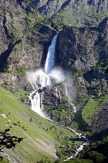
The Serio waterfall in the municipality is also worth seeing.
Not far from here is the Lago del Barbellino .
Web links
Individual evidence
- ↑ Statistiche demografiche ISTAT. Monthly population statistics of the Istituto Nazionale di Statistica , as of December 31 of 2019.


