
Taleggio (Lombardy)
| Taleggio | ||
|---|---|---|

|
|
|
| Country | Italy | |
| region | Lombardy | |
| province | Bergamo (BG) | |
| Local name | Day | |
| Coordinates | 45 ° 54 ' N , 9 ° 34' E | |
| height | 758 m slm | |
| surface | 46.6 km² | |
| Residents | 546 (Dec. 31, 2019) | |
| Population density | 12 inhabitants / km² | |
| Post Code | 24010 | |
| prefix | 0345 | |
| ISTAT number | 016210 | |
| Popular name | Taleggini | |
| Patron saint | Markus | |
| Website | Taleggio | |


Taleggio is a northern Italian municipality ( comune ) with 546 inhabitants (as of December 31, 2019) in the province of Bergamo in Lombardy . The municipality is located on the western edge of the Bergamasque Alps in the valley of the same name and about 37 kilometers north of Bergamo . The administrative seat of the municipality is in the locality of Sottochiesa. The other localities in the municipality are Olda, Peghera and Pizzino.
The cheese of the same name comes from this area.
 Panorama of the village of Olda
 Church of San Pietro e Paolo in Olda
 Madonna di Salzana
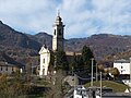 Pizzino Church


Individual evidence
- ↑ Statistiche demografiche ISTAT. Monthly population statistics of the Istituto Nazionale di Statistica , as of December 31 of 2019.

Adrara San Martino | Adrara San Rocco | Albano Sant'Alessandro | Albino | Algua | Almenno San Bartolomeo | Almenno San Salvatore | Almè | Alzano Lombardo | Ambivere | Antegnate | Arcene | Ardesio | Arzago d'Adda | Averara | Aviatico | Azzano San Paolo | Azzone | Bagnatica | Barbata | Bariano | Barzana | Bedulita | Berbenno | Bergamo | Berzo San Fermo | Bianzano | Blello | Bolgare | Boltiere | Bonate Sopra | Bonate Sotto | Borgo di Terzo | Bossico | Bottanuco | Bracca | Branzi | Brembate | Brembate di Sopra | Brignano Gera d'Adda | Brumano | Brusaporto | Calcinates | Calcio | Calusco d'Adda | Calvenzano | Camerata Cornello | Canonica d'Adda | Capizzone | Capriate San Gervasio | Caprino Bergamasco | Caravaggio | Carobbio degli Angeli | Carona | Carvico | Casazza | Casirate d'Adda | Casnigo | Cassiglio | Castel Rozzone | Castelli Calepio | Castione della Presolana | Castro | Cavernago | Cazzano Sant'Andrea | Cenate Sopra | Cenate Sotto | Cene | Cerete | Chignolo d'Isola | Chiuduno | Cisano Bergamasco | Ciserano | Cividate al Piano | Clusone | Colere | Cologno al Serio | Colzate | Comun Nuovo | Corna Imagna | Cornalba | Cortenuova | Costa Valle Imagna | Costa Volpino | Costa di Mezzate | Costa Serina | Covo | Credaro | Curno | Cusio | Dalmine | Dossena | Endine Gaiano | Entratico | Fara Gera d'Adda | Fara Olivana con Sola | Filago | Fino del Monte | Fiorano al Serio | Fontanella | Fonteno | Foppolo | Foresto Sparso | Fornovo San Giovanni | Fuipiano Valle Imagna | Gandellino | Gandino | Gandosso | Gaverina Terme | Gazzaniga | Ghisalba | Gorlago | Gorle | Gorno | Grassobbio | Gromo | Grone | Grumello del Monte | Isola di Fondra | Isso
Lallio | Leffe | Lenna | Levate | Locatello | Lovere | Lurano | Luzzana | Madone | Mapello | Martinengo | Medolago | Mezzoldo | Misano di Gera d'Adda | Moio de 'Calvi | Monasterolo del Castello | Montello | Morengo | Mornico al Serio | Mozzanica | Mozzo | Nembro | Olmo al Brembo | Oltre il Colle | Oltressenda Alta | Oneta | Onore | Orio al Serio | Ornica | Osio Sopra | Osio Sotto | Pagazzano | Paladina | Palazzago | Palosco | Parre | Parzanica | Pedrengo | Peia | Pianico | Piario | Piazza Brembana | Piazzatorre | Piazzolo | Pognano | Ponte Nossa | Ponte San Pietro | Ponteranica | Pontida | Pontirolo Nuovo | Pradalunga | Predore | Premolo | Presezzo | Pumenengo | Ranica | Ranzanico | Riva di Solto | Rogno | Romano di Lombardia | Roncobello | Roncola | Rota d'Imagna | Rovetta | San Giovanni Bianco | San Paolo d'Argon | San Pellegrino Terme | Sant'Omobono Terme | Santa Brigida | Sarnico | Scanzorosciate | Schilpario | Sedrina | Selvino | Seriate | Serina | Solto Collina | Solza | Songavazzo | Sorisole | Sotto il Monte Giovanni XXIII | Sovere | Spinone al Lago | Spirano | Stezzano | Strozza | Suisio | Taleggio | Tavernola Bergamasca | Telgate | Terno d'Isola | Torre Boldone | Torre Pallavicina | Torre de 'Roveri | Trescore Balneario | Treviglio | Treviolo | Ubiale Clanezzo | Urgnano | Val Brembilla | Valbondione | Valbrembo | Valgoglio | Valleve | Valnegra | Valtorta | Vedeseta | Verdellino | Verdello | Vertova | Viadanica | Vigano San Martino | Vigolo | Villa d'Adda | Villa d'Almè | Villa d'Ogna | Villa di Serio | Villongo | Vilminore di Scalve | Zandobbio | Zanica | Zogno