
Saint-Aignan (Morbihan)
|
Saint-Aignan Sant-Inan |
||
|---|---|---|
.svg)
|
|
|
| region | Brittany | |
| Department | Morbihan | |
| Arrondissement | Pontivy | |
| Canton | Gourin | |
| Community association | Pontivy Communauté | |
| Coordinates | 48 ° 11 ′ N , 3 ° 1 ′ W | |
| height | 67-275 m | |
| surface | 27.33 km 2 | |
| Residents | 605 (January 1, 2017) | |
| Population density | 22 inhabitants / km 2 | |
| Post Code | 56480 | |
| INSEE code | 56203 | |
| Website | http://www.saint-aignan56.fr/ | |

Saint-Aignan ( Breton : Sant-Inan ) is a French municipality with 605 inhabitants (at January 1, 2017) in the department of Morbihan in the region of Brittany . It belongs to the community association Pontivy Communauté .
geography
Saint-Aignan is located in the north of the Morbihan department on the border with the Côtes-d'Armor department and belongs to the Pays de Pontivy.
Neighboring municipalities are the municipalities in the Côtes-d'Armor department
- Bon Repos sur Blavet with Saint-Gelven in the north,
- Caurel also in the north,
- Guerlédan with Mûr-de-Bretagne in the east,
- Neulliac in the southeast,
- Cléguérec in the south,
- Sainte-Brigitte to the west.
Because of its proximity to Mûr-de-Bretagne, the place is close to roads for national traffic. The D18 / D35 runs through the municipality from Plouay towards Mûr-de-Bretagne. The most important road connection is the N164, which passes just a few kilometers away in the north.
The most important body of water is the Lac de Guerlédan reservoir in the north of the municipality. There are also numerous ponds in the municipality. Another important body of water is the Blavet River . At the same time, these partially form the municipal and departmental borders. A not insignificant part of the community area is covered by forests. The largest are the Forêt de Quénécan , Bois du Pouldu , Bois de Toul er Roc'h and Bois de Brons .
Population development
| year | 1962 | 1968 | 1975 | 1982 | 1990 | 1999 | 2006 |
| Residents | 924 | 772 | 706 | 651 | 612 | 629 | 670 |
history
Historically, the municipality belongs to the Breton region of Bro Gwened (French: Vannetais) and within this region to the Bro Pondi (French: Pays de Pontivy) area and shares its history. Since 1793, Saint-Aignan has belonged to the canton of Cléguérec.
Attractions
- Saint-Aignan village church from the 15th century; restored several times and expanded in 1894
- Saint-Ignace Chapel in the Quénécan Forest from the 17th century
- Saint-Marc Chapel in the Quénécan Forest from 1688
- Chapel of Sainte-Tréphine in Castel-Finans from 1897
- Farm in Corboulo from 1793
- Bot-Pleven mansion from the 16th century
- House Porh-Antoine from 1733
- the three fountains Saint-Ignace, Saint-Méen and Notre-Dame des Forces by the Saint-Ignace chapel from the 17th century
- Remains of the prehistoric camp of Castel-Finans from the Iron Age
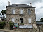
Mayor's office in Saint-Aignan
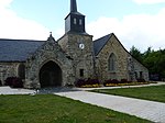
Saint-Aignan village church
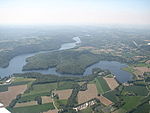
Aerial view of the Lac de Guerlédan reservoir

Remains of the Castel-Finans camp


literature
- Le Patrimoine des Communes du Morbihan. Flohic Editions, Volume 1, Paris 1996, ISBN 2-84234-009-4 , pp. 190-193.
Individual evidence
- ↑ Official website of the CC du Pays de PontivyCC (French)
- ↑ Map with the municipalities of the Pays de Pontivy ( Memento of the original from January 11, 2012 in the Internet Archive ) Info: The archive link has been inserted automatically and has not yet been checked. Please check the original and archive link according to the instructions and then remove this notice.
- ↑ Saint-Aignan on Cassini.ehess.fr (French)
- ↑ Sights (English)
- ↑ Sights of the community ( Memento of the original from September 24, 2008 in the Internet Archive ) Info: The archive link was automatically inserted and not yet checked. Please check the original and archive link according to the instructions and then remove this notice. (French)